Western New Guinea, also known as Papua, Indonesian New Guinea, and Indonesian Papua, is the western half of the island of New Guinea, formerly Dutch and granted to Indonesia in 1962. Given the island is alternatively named Papua, the region is also called West Papua (Indonesian: Papua Barat). It is one of the seven geographical units of Indonesia in ISO 3166-2:ID. (Full article...)
An Australian soldier, Private George "Dick" Whittington, is aided by Papuan orderly Raphael Oimbari, near Buna on 25 December 1942.
New Guinea Force was a military command unit for Australian, United States and native troops from the Territories of Papua and New Guinea serving in the New Guinea campaign during World War II. Formed in April 1942, when the Australian First Army was formed from the Australian I Corps after it returned from the Middle East, it was responsible for planning and directing all operations within the territory up until October 1944. General Headquarters Southwest Pacific Area Operational Instruction No.7 of 25 May 1942, issued by Commander-Allied-Forces, General Douglas MacArthur, placed all Australian and US Army, Air Force and Navy Forces in the Port Moresby Area under the control of New Guinea Force. Over the course of its existence, New Guinea Force was commanded by some of the Australian Army's most notable commanders, including Sydney Rowell, Sir Edmund Herring and Sir Leslie Morshead.
The Sepik has a large catchment area, and landforms that include swamplands, tropical rainforests and mountains. Biologically, the river system is often said to be possibly the largest uncontaminated freshwater wetland system in the Asia-Pacific region. But, in fact, numerous fish and plant species have been introduced into the Sepik since the mid-20th century. (Full article...)
Image 3
Copper ore concentrator undergoing construction, c. 1971
The Panguna mine is a large copper mine located in Bougainville, Papua New Guinea. Panguna represents one of the largest copper reserves in Papua New Guinea and in the world, having an estimated reserve of one billion tonnes of ore copper and twelve million ounces of gold. The mine has been closed since 1989 and has ceased all production. (Full article...)
Image 4
Matschie's tree-kangaroo, an endangered endemic species found in Huon Peninsula Papua New Guinea together with the West Papua region of Indonesia (New Guinea) makes up a major tropical wilderness area that still contains 5% of the original and untouched tropical high-biodiversity terrestrial ecosystems. PNG in itself contains over 5% of the world's biodiversity in less than 1% of the world's total land area. The flora of New Guinea is unique because it has two sources of origin; the Gondwana flora from the south and flora with Asian origin from the west. As a result, New Guinea shares major families and genera with Australia and East Asia, but is rich in local endemic species. Endemism is a result of mountainous isolation, topographic and soil habitat heterogeneity, high forest disturbance rates and abundant aseasonal rainfall year round. PNG boasts some 15–21,000 higher plants, 3,000 species of orchids, 800 species of coral, 600 species of fish, 250 species of mammals and 760 species of birds and 8 species of tree-kangaroos of which 84 genera of animals are endemic. Ecosystems range from lowland forests to montane forests, alpine flora down to coastal areas which contain some of the most extensive pristine mangrove areas in the world. Much of this biodiversity has remained intact for thousands of years because the ruggedness of the terrain made the interior lands inaccessible; furthermore low population density and restrictions on the effectiveness of traditional tools, ensured that this biodiversity was never overexploited. (Full article...)
The eastern part of the plateau, east of the Sioa River, covers about 525 square miles (1,360 km2) and had a sparse population of 2,100 people (1966 government census), speaking at least five different languages. The dominant ethnic groups of this region are the Bosavi, Hawalisi, and Onabasulu. Further to the west are the Etoro, Bedamuni, and Sonia. In general, these groups practice swidden agriculture with exploitation of taro.
The Great Papuan Plateau has petroleum resources, and a pipeline from the plateau to Daru is under construction. (Full article...)
General elections were held in Papua New Guinea between 24 June and 8 July 2017. The writs for the election were issued on 20 April, and candidate nominations closed on 27 April.
On 1 August 2017 Peter O'Neill was re-elected as prime minister by Parliament by a vote of 64–40. (Full article...)
Image 8
Port Moresby (/ˈmɔːrzbi/ⓘ; Tok Pisin: Pot Mosbi), also referred to as Pom City or simply Moresby, is the capital and largest city of Papua New Guinea. It is one of the largest cities in the southwestern Pacific (along with Jayapura) outside of Australia and New Zealand. It is located on the shores of the Gulf of Papua, on the south-western coast of the Papuan Peninsula of the island of New Guinea. The city emerged as a trade centre in the second half of the 19th century. During World War II, it was a prime objective for conquest by the Imperial Japanese forces during 1942–43 as a staging point and air base to cut off Australia from Southeast Asia and the Americas. Due to its population and outsized influence compared to other cities in Papua New Guinea, Port Moresby may be regarded as a primate city.
As of the 2011 census, Port Moresby had 364,145 inhabitants. An unofficial 2020 estimate gives the population as 383,000. The place where the city was founded has been inhabited by the Motu-Koitabu people for centuries. The first Briton to see it was Royal Navy Captain John Moresby in 1873. It was named in honour of his father, Admiral of the Fleet Sir Fairfax Moresby.
The Papua New Guinea Defence Force (PNGDF) is the military organisation responsible for the defence of Papua New Guinea. It originated from the Australian Army land forces of the territory of Papua New Guinea before independence, coming into being in January 1973 and having its antecedents in the Pacific Islands Regiment. The PNGDF is a small force, numbering around 3,600 personnel, and consists of a Land Element, an Air Element and a Maritime Element. It is a joint force tasked with defending Papua New Guinea and its territories against external attack, as well as having secondary functions including national-building and internal security tasks.
Defence accounts for less than 2% of GDP, while also receiving significant assistance and training support from Australia, New Zealand, the United States, and other nations.
The PNGDF Land Element includes two infantry battalions, an engineer battalion, a signal squadron, an Explosive Ordnance Disposal (EOD) unit, and a preventive medicine platoon. The Air Element is a small air wing operating three light transport aircraft and two leased helicopters. The Maritime Element consists of four Guardian-class patrol boats and two landing craft. The army is under the direct command of Headquarters PNGDF, while the air wing and navy have their own commanding officers. The PNGDF does not have a Commander-in-Chief but rather a Commander who advises the Minister for Defence. Allegiance is sworn to the King of Papua New Guinea, Presently Charles III, and the realm of Papua New Guinea. The PNGDF is under the control of the National Executive Council through the Minister for Defence. (Full article...)
Kokopo was known as Herbertshöhe (Herbert's Heights), named in honour of Herbert, eldest son of German Chancellor Otto von Bismarck, during the German New Guinea administration, which controlled the area between 1884 and formally until 1919. Until 1910, it was the capital of German New Guinea.
On Sunday, March 29, 2015, a strong earthquake, of a preliminary magnitude of at least 7.5, which at that time was the largest earthquake of 2015, was recorded near Kokopo, and a tsunami warning was issued. This was surpassed a month later by the April 2015 Nepal earthquake, which measured a magnitude 7.8. (Full article...)
Milne Bay is a province of Papua New Guinea. Its capital is Alotau. The province covers 14,345 km2 of land and 252,990 km2 of sea, within the province there are more than 600 islands, about 160 of which are inhabited. The province has about 276,000 inhabitants, speaking about 48 languages, most of which belong to the Eastern Malayo-Polynesian branch of the Austronesian language family. Economically the province is dependent upon tourism, oil palm, and gold mining on Misima Island; in addition to these larger industries there are many small-scale village projects in cocoa and copra cultivation. The World War IIBattle of Milne Bay took place in the province.
Culturally the Milne Bay region is sometimes referred to as the Massim, a term originating from the name of Misima Island. Massim societies are usually characterized by matrilineal descent, elaborate mortuary sequences and complex systems of ritual exchange including the Kula ring. From island group to island group and even between close lying islands, the local culture changes remarkably. What is socially acceptable on one island may not be so on another. (Full article...)
The competition has been won by only two clubs. Hekari United won the first eight editions, while Lae City have won the rest. The two clubs have met in two Grand Finals, in 2015–16 and 2019, with Lae City winning both. (Full article...)
Image 15
The white-lipped tree frog (Nyctimystes infrafrenatus) is a species of frog in the subfamily Pelodryadinae. It is the world's largest tree frog (the Cuban tree frog reaches a similar maximum size) and is found in Australia. Other common names include the New Guinea treefrog, giant tree frog, and Australian giant treefrog. (Full article...)
... that Australian official Jack Emanuel was awarded the George Cross in 1971 after being stabbed to death whilst trying to resolve a land dispute with the Tolai people of New Guinea?
Image 22New Guinea from 1884 to 1919. The Netherlands controlled the western half of New Guinea, Germany the north-eastern part, and Britain the south-eastern part. (from New Guinea)
Image 23Map showing the combined landmass of Sahul formed during Pleistocene glacations (from New Guinea)
Image 70An Australian soldier, Private George "Dick" Whittington, is aided by Papuan orderly Raphael Oimbari, near Buna on 25 December 1942. (from History of Papua New Guinea)


 British flag raised in Queensland 1883 (from History of Papua New Guinea)
 Fort Du Bus in 1828 (from Western New Guinea)
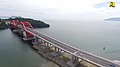 Youtefa Bridge, currently the longest bridge in Papua (from Western New Guinea)

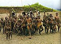 Yali in the Yahukimo Regency (from Western New Guinea)
 A 1644 map of New Guinea and the surrounding area (from New Guinea)
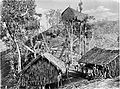 Koiari village near Bootless Inlet, British New Guinea (from History of Papua New Guinea)
 The continent of Sahul before the rising ocean sundered Australia and New Guinea after the last ice age (from New Guinea)
 Map of New Guinea, with place names as used in English in the 1940s (from New Guinea)
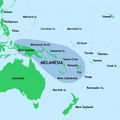 New Guinea located in relation to Melanesia (from New Guinea)
 Dutch colonial civil servant in the Baliem Valley, 1958 (from Western New Guinea)
 The lowland rainforest of the Western New Guinea (from Western New Guinea)
 Paradisaea apoda, native to Papua, displaying its feathers (from Western New Guinea)
 Flag under German control of New Guinea. (from History of Papua New Guinea)
 Sentani International Airport in Jayapura is the principal point of entry to Papua (from Western New Guinea)
 Dutch expeditions in Netherlands New Guinea 1907–1915. (from Western New Guinea)
 New Guinea Volunteer Rifles with captured Japanese flag, 1942 (from History of Papua New Guinea)
 Culture parade in Biak (from Western New Guinea)
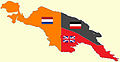 New Guinea from 1884 to 1919. The Netherlands controlled the western half of New Guinea, Germany the north-eastern part, and Britain the south-eastern part. (from New Guinea)
 The Nagarakertagama mentioned a region in the east called Wanin, present-day Onin Peninsula in the Fakfak Regency, West Papua (from Western New Guinea)
 Kerepunu women at the marketplace of Kalo, British New Guinea, 1885 (from History of Papua New Guinea)
 Papuans on the Lorentz River, photographed during the third South New Guinea expedition in 1912–13 (from New Guinea)
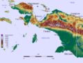 The rugged and mountainous topography of Western New Guinea. (from Western New Guinea)
 Grasberg Mine in Mimika Regency. Mining is the most important sector in the province (from Western New Guinea)
 Regions of Oceania: Australasia, Polynesia, Micronesia, and Melanesia. Australasia includes the Australian landmass (including Tasmania), New Zealand, and New Guinea. (from History of Papua New Guinea)
 The raggiana bird-of-paradise is native to New Guinea. (from New Guinea)
 West Papuan separatists raising the Morning-Star flag in the jungles of Papua, 1971 (from Western New Guinea)
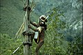 Yali Mabel, Kurulu Village War Chief at Baliem Valley (from New Guinea)
 Fishing boats in Biak (from Western New Guinea)
 Topographical map of New Guinea (from New Guinea)
 Sago is a typical Papuan food, which is usually made into papeda. (from Western New Guinea)
 The floristic region of Malesia (from New Guinea)
 Australian patrol officer in 1964 (from History of Papua New Guinea)
 Group of natives at Mairy Pass. Mainland of British New Guinea in 1885. (from New Guinea)
 Handover ceremony of West Irian Governorship from Jan Bonay to Frans Kaisiepo, 1965 (from Western New Guinea)
 Hoisting the German flag at Mioko in 1884 (from History of Papua New Guinea)
 Coral reefs in Papua New Guinea (from New Guinea)
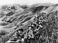 Australian soldiers resting in the Finisterre Ranges of New Guinea while en route to the front line (from New Guinea)
 Political divisions of New Guinea (2006) (from New Guinea)
 Skouw border checkpoint, on the Indonesia-Papua New Guinea border (from Western New Guinea)
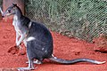 Dorcopsis hageni, native to northern region of New Guinea. (from Western New Guinea)
 A Japanese military map of New Guinea from 1943 (from New Guinea)
 Trans-New Guinea languages (multi-coloured), Austronesian languages (gold), and other languages (grey) (from Western New Guinea)
 Australian forces attack Japanese positions during the Battle of Buna–Gona, 7 January 1943. (from History of Papua New Guinea)
 Highlands of Papua New Guinea (from New Guinea)
 Rp 0.12 Indonesian stamp of 1963. (from Western New Guinea)
![Image 54M.S. Rumagesan, Silas Papare, N.L.Suwages, Soegoro Atmoprasodjo [id], and A.H. Nasution in Putra-putra Irian Barat ('Sons of Irian Barat') Conference in Cibogo Bogor, 14–15 April 1961 (from Western New Guinea)](//upload.wikimedia.org/wikipedia/commons/thumb/7/74/MS_Rumagesan%2C_Silas_Papare%2C_NL_Suwages%2C_Sugoro%2C_dan_AH_Nasution_berbincang-bincang%2C_Konferensi_Cibogo.jpg/120px-MS_Rumagesan%2C_Silas_Papare%2C_NL_Suwages%2C_Sugoro%2C_dan_AH_Nasution_berbincang-bincang%2C_Konferensi_Cibogo.jpg) M.S. Rumagesan, Silas Papare, N.L.Suwages, Soegoro Atmoprasodjo, and A.H. Nasution in Putra-putra Irian Barat ('Sons of Irian Barat') Conference in Cibogo Bogor, 14–15 April 1961 (from Western New Guinea)
M.S. Rumagesan, Silas Papare, N.L.Suwages, Soegoro Atmoprasodjo, and A.H. Nasution in Putra-putra Irian Barat ('Sons of Irian Barat') Conference in Cibogo Bogor, 14–15 April 1961 (from Western New Guinea)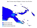 Papua New Guinea map of Köppen climate classification (from New Guinea)
 The Sukarno-era West Irian Liberation Monument in Lapangan Banteng, Jakarta. (from Western New Guinea)
 Female gable image, Sawos people, Oceanic art in the Bishop Museum (from History of Papua New Guinea)
 Free West Papua protest in Melbourne, Australia, August 2012. (from Western New Guinea)
 Jayapura, the most populous and largest city on the island of New Guinea (Papua) (from New Guinea)
 Dutch and Papuan officials during the opening of the Central Hospital in Hollandia, 1959 (from Western New Guinea)
 New Guinea crocodile (from New Guinea)
 Australian troops at Milne Bay, Papua.The Australian garrison was the first to inflict defeat on the Imperial Japanese Army during World War II at the Battle of Milne Bay of Aug–Sep 1942. (from History of Papua New Guinea)
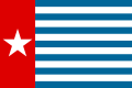 Since 2002, display of the flag of West Papua is allowed in West Papua only if accompanied by, and not raised higher than, the flag of Indonesia. (from Western New Guinea)
 Papeda, a notable dish originating from Eastern Indonesia (from Western New Guinea)
 The king bird-of-paradise is one of over 300 bird species on the peninsula. (from Western New Guinea)
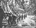
 Mount Bosavi (from New Guinea)
 An Australian soldier, Private George "Dick" Whittington, is aided by Papuan orderly Raphael Oimbari, near Buna on 25 December 1942. (from History of Papua New Guinea)
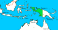 Western New Guinea was formally annexed by Indonesia in 1969. (from New Guinea)
 A section of Trans-Papua Highway connecting Deiyai and Mimika in Central Papua (from Western New Guinea)


.svg)


.jpg)

.jpg)

.png)


,_Pairi_daiza_2.jpg)


.jpg)
.jpg)

![Image 54M.S. Rumagesan, Silas Papare, N.L.Suwages, Soegoro Atmoprasodjo [id], and A.H. Nasution in Putra-putra Irian Barat ('Sons of Irian Barat') Conference in Cibogo Bogor, 14–15 April 1961 (from Western New Guinea)](/wiki/File:MS_Rumagesan,_Silas_Papare,_NL_Suwages,_Sugoro,_dan_AH_Nasution_berbincang-bincang,_Konferensi_Cibogo.jpg)


 Commons
 Wikibooks
 Wikidata
 Wikinews
 Wikiquote
 Wikisource
 Wikiversity
 Wiktionary


