Babbila Subdistrict
Appearance
This article relies largely or entirely on a single source. (February 2025) |
Babbila Subdistrict
ناحية ببيلا | |
|---|---|
Subdistrict | |
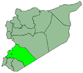
 Location of Babbila Subdistrict within Rif Dimashq Governorate | |
| Country | |
| Governorate | Rif Dimashq Governorate |
| District | Markaz Rif Dimashq District |
| Area | |
• Total | 75.77 km2 (29.25 sq mi) |
| Population (2004) | |
• Total | 341,625 |
| • Density | 4,500/km2 (12,000/sq mi) |
Babbila Subdistrict (Arabic: ناحية ببيلا) is a subdistrict (nāḥiya) of Markaz Rif Dimashq District in Rif Dimashq Governorate, Syria. The administrative center is the town of Babbila. According to the 2004 census, the subdistrict had a population of 341,625.[1]
Towns and villages
[edit]The subdistrict includes the following towns and villages:
- Aqraba
- Babbila
- Al-Bahdaliyah
- Beit Sahem
- Al-Buwaydah
- Hujayrah
- Hawsh Sahiya
- Khirbet al-Ward
- Najha
- Sayyidah Zaynab
- Al-Sabinah
- Yalda
References
[edit]- ^ "General Census of Population 2004". Central Bureau of Statistics (Syria). Archived from the original on 15 December 2019. Retrieved 8 April 2013.


