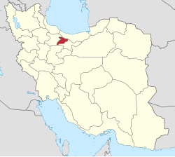
Zafaraniyeh, Alborz
Zafaraniyeh
Persian: زعفرانيه | |
|---|---|
Village | |
| Coordinates: 35°49′03″N 50°41′16″E / 35.81750°N 50.68778°E[1] | |
| Country | Iran |
| Province | Alborz |
| County | Chaharbagh |
| District | Ramjin |
| Rural District | Aghlan Tappeh |
| Population (2016)[2] | |
• Total | 146 |
| Time zone | UTC+3:30 (IRST) |
Zafaraniyeh (Persian: زعفرانيه)[a] is a village in Aghlan Tappeh Rural District[4] of Ramjin District in Chaharbagh County, Alborz province, Iran.
Demographics
[edit]Population
[edit]At the time of the 2006 National Census, the village's population was 107 in 34 households, when it was in Ramjin Rural District of Chaharbagh District[b] in Savojbolagh County, Tehran province.[5] The 2016 census measured the population of the village as 146 in 56 households,[2] by which time the county had been separated from the province in the establishment of Alborz province.[6]
In 2020, the district was separated from the county in establishing Chaharbagh County and renamed the Central District. The rural district was transferred to the new Ramjin District, and Zafaraniyeh was transferred to Aghlan Tappeh Rural District created in the district.[4]
See also
[edit]Notes
[edit]- ^ Also romanized as Zaʿfarānīyeh[3]
- ^ Renamed the Central District of Chaharbagh County[4]
References
[edit]- ^ OpenStreetMap contributors (7 April 2025). "Shahrak Zaferanieh, Oghlan Tappeh RD, Ramjin District, Chaharbagh County, Alborz Province, Iran" (Map). OpenStreetMap (in Persian). Retrieved 7 April 2025.
- ^ a b سرشماري عمومي نفوس و مسكن 1395 : استان البرز [General Population and Housing Census 2016: Alborz Province]. مرکز آمار ایران [Statistical Centre of Iran] (in Persian). Archived from the original (Excel) on 28 January 2020. Retrieved 22 June 2025.
- ^ "INCSGN Search". Iranian National Committee for Standardization of Geographical Names (in Persian). Tehran: National Cartographic Center of Iran. Archived from the original on 2 May 2019.
- ^ a b c Jahangiri, Eshaq (8 December 2020) [۱۳۹۹/۹/۱۸ تاریخ ابلاغ (Notification date 1399/9/18) (Iranian Jalali calendar)]. تصویب نامه در خصوص تقسیمات کشوری در شهرستان ساوجبلاغ استان البرز [Letter of approval regarding national divisions in Savojbolagh County, Alborz province]. مرکز پژوهشهای مجلس شورای اسلامی ایران [Research Center of the Islamic Consultative Assembly of Iran] (in Persian). وزارت کشور [Ministry of the Interior]. هیات وزیران [Council of Ministers]. شماره۱۰۴۹۲۲/ت۵۷۲۶۱ه [Notification Number 104922/T57261H]. Archived from the original on 24 June 2021. Retrieved 20 June 2025.
- ^ سرشماري عمومي نفوس و مسكن 1385 : استان تهران [General Population and Housing Census 2006: Tehran Province]. مرکز آمار ایران [Statistical Centre of Iran] (in Persian). Archived from the original (Excel) on 20 September 2011. Retrieved 22 June 2025.
- ^ Larijani, Ali (23 June 2010) [تاریخ تصویب (Approval date) 1389/04/02 (Iranian Jalali calendar)]. قانون تأسیس استان البرز [Law on the establishment of Alborz province]. لام تا کام [Lam ta Kam] (in Persian). وزارت کشور [Ministry of the Interior]. مجلس شورای اسلامی [Islamic Consultative Assembly]. نامه شماره [Letter Number] 30588/412. Archived from the original on 16 December 2023. Retrieved 20 June 2025.


