
Yakushima
This article needs additional citations for verification. (May 2025) |
Native name: Japanese: 屋久島 | |
|---|---|
Landsat image of Yakushima | |
 Yakushima Location in Japan (with southern islands in inset)  Yakushima Yakushima (Kagoshima Prefecture) | |
| Geography | |
| Location | East China Sea |
| Coordinates | 30°20′38″N 130°31′26″E / 30.34389°N 130.52389°E |
| Archipelago | Ryukyu Islands |
| Area | 504.88 km2 (194.94 sq mi) |
| Highest elevation | 1,936 m (6352 ft) |
| Highest point | Mount Miyanoura |
| Administration | |
| Kagoshima Prefecture | |
| Demographics | |
| Population | 11,698 (2022) |
| Pop. density | 26.1/km2 (67.6/sq mi) |
| Ethnic groups | Japanese |
| Criteria | Natural: vii, ix |
| Reference | 662 |
| Inscription | 1993 (17th Session) |
| Area | 10,747 ha |
| Official name | Yakushima Nagata-hama |
| Designated | 8 November 2005 |
| Reference no. | 1559[1] |
Yakushima (屋久島) is one of the Ōsumi Islands in Kagoshima Prefecture, Japan. The island, 504.88 km2 (194.94 sq mi) in area, has a population of 11,858.[2] It is accessible by hydrofoil ferry, car ferry, or by air to Yakushima Airport.
The island is part of the town (chō) of Yakushima, which includes the neighbouring island of Kuchinoerabujima. 42% of the island is within the borders of the Yakushima National Park.[3]
Yakushima's electricity is more than 50% hydroelectric, and surplus power has been used to produce hydrogen gas in an experiment by Kagoshima University. The island has been a test site for Honda's hydrogen fuel cell vehicle research.
World Heritage designation
[edit]In 1980, an area of 18,958 ha (46,850 acres) was designated a UNESCO Man and the Biosphere Reserve.[4] In 1993, 10 hectares (25 acres) of wetland at Nagata-hama was designated a Ramsar site.[5] Yakushima is the largest nesting ground for the endangered loggerhead sea turtle in the North Pacific.[3][6] The island's unique remnant of warm/temperate ancient forest has been a natural World Heritage Site since 1993.
Geography
[edit]Overview
[edit]
Yakushima is located approximately 61.3 kilometres (38.1 mi) south of the southern tip of Ōsumi Peninsula in southern Kyushu, or 135 kilometres (73 nmi) south of Kagoshima. The Vincennes Strait (Yakushima Kaikyō) separates it from the nearby island of Tanegashima, which is home to the Japanese Space Centre. Periodic rocket launches from Tanegashima can clearly be seen from Yakushima.[citation needed]
The bedrock of the island is granite, so there are no active volcanoes.[7] The island has an area of 504.5 square kilometres (194.8 sq mi) and is roughly circular, with a circumference of 89 kilometres (55 mi) and a diameter of 28 kilometres (17 mi). Its highest elevations are Miyanouradake (宮之浦岳), at 1,935 metres (6,348 ft), and Nagatadake (永田岳), at 1,886 metres (6,188 ft). Yakushima has another 30 peaks of over 1,000 metres (3,300 ft) in height. There are numerous hot springs on the island.[citation needed]
-
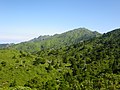 Yakushima Mitake, Mount Miyanoura, Mount Nagata, and Mount Kurio
 -

-
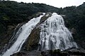 Ooko Falls
 -
 Senpiro Falls

_05.jpg)


Settlements
[edit]Major settlements of the island, which make up Yakushima municipality, are the port towns of Anbō and Miyanoura; between them is located Yakushima Airport. Other settlements are the coastal villages of Onoaida, Hirauchi, Kurio, Nagata, and the abandoned forest village of Kosugidani.
History
[edit]This section needs additional citations for verification. (May 2025) |
Yakushima has been settled since at least the Jōmon period. It was first mentioned in written documents of the Chinese Sui dynasty of the 6th century. In 601, the Chinese sent an expedition to the "Country of Liukiu" (流求國). They noted that the people were small but pugnacious. They could not understand the local language, however, and returned to China. In 607, they sent another expedition to trade and brought back one of the islanders.
In the ancient Japanese history text Shoku Nihongi, in an entry dated 702 CE, it is said that Yakushima formed part of ancient Tane Province.
During the Edo period, Yakushima was ruled by the Shimazu clan of the Satsuma Domain and was considered part of Ōsumi Province. Following the Meiji restoration, the island has been administered as part of Kagoshima Prefecture.
In 2017, Yakushima was struck by Typhoon Noru, causing one death.
In November 2023, a United States Air Force V-22 Osprey crashed off the coast of Yakushima, killing seven crew members, with one crewmember going missing.[8][9][10]
Demographics and economics
[edit]The population of Yakushima reached a peak in 1960, with 24,010 inhabitants.[citation needed] It thereafter declined until about 1995 but has subsequently stabilized at 12,053 inhabitants as of 2020.[11]
Traditionally, the economic mainstays of the population were forestry and the export of wood products (principally cedar roof shingles), and commercial fishing. Cultivation of oranges and tea, the distilling of shōchū, and tourism are now the main sources of income. [citation needed]
Flora and fauna
[edit]This section needs additional citations for verification. (May 2025) |
Yakushima contains one of the largest tracts of existing Nansei Islands subtropical evergreen forests, an endangered habitat ecoregion.[12] The only large animals indigenous to the island are Yakushima macaques and a variety of sika deer. The Japanese raccoon dog is also a common animal but is not native to the island. Japanese weasels (Mustela itatsi) may also be seen from time to time. The island is a spawning ground for migratory loggerhead turtles, and dolphins are to be found offshore. The coastal areas have coral reefs in places, although to a much lesser extent than are found farther south in the islands of Okinawa. Yakushima, along with neighbouring Tanegashima, has been recognised as an Important Bird Area by BirdLife International, because they support populations of Japanese wood pigeons, Ryukyu green pigeons, and Ryukyu robins.[13]
Yakushima is known for its lush vegetation. Most of the island has at one time or another been logged (dating back at least to the early Edo period) but has been extensively replanted and reseeded since logging ended in the late 1960s, at which time a conservation regime was established. In addition to this secondary forest, there are some remaining areas of primary forest, composed mainly of a variety of Cryptomeria japonica, or Japanese cedar, called yakusugi (屋久杉), the best-known single example of which is Jōmon Sugi (縄文杉), as its age is estimated to date to at least the Jōmon period of Japanese history, 2,300 years ago. In addition, the island lists over 50 varieties of endemic flowers, notably rhododendrons, and hundreds of rare endemic Bryophyta, as well as a number of endemic trees.


Climate
[edit]Yakushima has a humid subtropical climate (Köppen climate classification Cfa) with hot, humid summers and mild winters. Precipitation is extremely heavy, with at least 250 millimetres (9.8 in) in each month and as much as 773 millimetres (30.4 in) in June alone. Yakushima is Japan's wettest place,[14] and annual precipitation there is one of the world's highest, at 4,000 to 10,000 mm (160 to 390 in). There are drier periods in autumn and winter, while the heaviest downpours occur in spring and summer, often accompanied by landslides.[citation needed] It is the southernmost place in Japan where there is snow in the mountains, often for months, while the ocean temperature is never below 19 °C (66 °F)[citation needed]
| Climate data for Yakushima (1991–2020 normals, extremes 1937–present) | |||||||||||||
|---|---|---|---|---|---|---|---|---|---|---|---|---|---|
| Month | Jan | Feb | Mar | Apr | May | Jun | Jul | Aug | Sep | Oct | Nov | Dec | Year |
| Record high °C (°F) | 25.3 (77.5) |
26.1 (79.0) |
29.6 (85.3) |
29.8 (85.6) |
31.9 (89.4) |
34.8 (94.6) |
35.2 (95.4) |
35.4 (95.7) |
34.7 (94.5) |
31.3 (88.3) |
32.2 (90.0) |
26.6 (79.9) |
35.4 (95.7) |
| Mean daily maximum °C (°F) | 14.7 (58.5) |
15.5 (59.9) |
18.0 (64.4) |
21.4 (70.5) |
24.5 (76.1) |
26.9 (80.4) |
30.5 (86.9) |
30.9 (87.6) |
28.9 (84.0) |
25.2 (77.4) |
21.2 (70.2) |
16.8 (62.2) |
22.9 (73.2) |
| Daily mean °C (°F) | 11.8 (53.2) |
12.3 (54.1) |
14.6 (58.3) |
17.8 (64.0) |
21.0 (69.8) |
23.7 (74.7) |
27.0 (80.6) |
27.5 (81.5) |
25.7 (78.3) |
22.2 (72.0) |
18.2 (64.8) |
13.9 (57.0) |
19.6 (67.3) |
| Mean daily minimum °C (°F) | 8.9 (48.0) |
9.2 (48.6) |
11.3 (52.3) |
14.2 (57.6) |
17.5 (63.5) |
21.0 (69.8) |
23.9 (75.0) |
24.6 (76.3) |
22.8 (73.0) |
19.4 (66.9) |
15.2 (59.4) |
11.0 (51.8) |
16.6 (61.9) |
| Record low °C (°F) | 1.0 (33.8) |
0.7 (33.3) |
1.5 (34.7) |
4.5 (40.1) |
10.1 (50.2) |
13.7 (56.7) |
18.3 (64.9) |
19.6 (67.3) |
15.2 (59.4) |
9.1 (48.4) |
5.6 (42.1) |
2.2 (36.0) |
0.7 (33.3) |
| Average precipitation mm (inches) | 294.6 (11.60) |
289.2 (11.39) |
387.0 (15.24) |
405.5 (15.96) |
444.1 (17.48) |
860.3 (33.87) |
362.4 (14.27) |
256.5 (10.10) |
450.7 (17.74) |
309.9 (12.20) |
309.6 (12.19) |
281.8 (11.09) |
4,651.7 (183.14) |
| Average snowfall cm (inches) | 0 (0) |
0 (0) |
0 (0) |
0 (0) |
0 (0) |
0 (0) |
0 (0) |
0 (0) |
0 (0) |
0 (0) |
0 (0) |
0 (0) |
0 (0) |
| Average precipitation days (≥ 0.5 mm) | 17.2 | 15.2 | 16.2 | 13.5 | 13.7 | 19.6 | 12.5 | 14.6 | 15.5 | 12.8 | 12.8 | 15.8 | 179.3 |
| Average relative humidity (%) | 68 | 68 | 69 | 71 | 76 | 85 | 83 | 82 | 81 | 74 | 71 | 69 | 75 |
| Mean monthly sunshine hours | 74.9 | 83.2 | 117.9 | 146.2 | 152.7 | 100.0 | 209.9 | 201.3 | 139.8 | 115.9 | 97.3 | 78.8 | 1,515.8 |
| Source: Japan Meteorological Agency[15] | |||||||||||||
This graph was using the legacy Graph extension, which is no longer supported. It needs to be converted to the new Chart extension. |
See or edit raw graph data.
Pollution
[edit]According to a disputed theory published in a 2009 paper,[16] airborne pollutants from China may have affected the Yakushima white pine.[17]
Transportation
[edit]Airport
[edit]Yakushima Airport (KUM) is the only airfield serving the island.
Ferries
[edit]Tanegayaku High Speed Ship Jetfoil "Toppy" "Rocket"
- Kagoshima Port, Minato Pier, Kagoshima City – Ibusuki Port (Ibusuki City) in Tanegashima, Nishinoomote Port (Nishinoomote City), Yakushima, Miyanoura Port, or Anbo Port.
Other
[edit]- Orita Kisen "Ferry Yakushima 2"
- Kagoshima Minato-ku Minami Pier-Yakushima / Miyanoura Port
- Kagoshima Merchant Ship & Shinyashiki Shoji Ferry "Haibisukasu" [40]
- Taniyama Port 2 Ward (Kagoshima City) – Tanegashima Nishinoomote Port (Nishinoomote City) – Yakushima Miyanoura Port
- Yakushima Town "Ferry Taiyo"
- Kuchinoerabujima – Yakushima / Miyanoura Port – Tanegashima / Shimama Port (Minamitanemachi)
Railway
[edit]The last operating narrow-gauge (762mm gauge) timber railway in Japan is on the island, but it only transports freight.
Hot springs
[edit]There are several onsen (hot springs) on Yakushima:
- Hirauchi underwater hot spring
- Jomon no Yado Manten
- Onoma Onsen
- Oura hot spring
- Yakushima Onsen
- Yodogawa Onsen
- Yudomari Onsen
- Yunoko no Yu
In popular culture
[edit]- The forests of Yakushima inspired the forest setting in Hayao Miyazaki's film Princess Mononoke.[18]
- Yakushima is the inspiration behind the forest of Dremuchij in Metal Gear Solid 3: Snake Eater.[19]
- The fictional characters Jun and Jin Kazama of Tekken lived on Yakushima.[20][21]
- The landscapes in Oni: Thunder God's Tale are inspired by Yakushima's forests.[22]
- The main setting of episodes 1153 and 1154 of Detective Conan is Yakushima, where a murder takes place deep in the forest near the ancient Jōmon Sugi.[23]
See also
[edit]Notes
[edit]- ^ "Yakushima Nagata-hama". Ramsar Sites Information Service. Retrieved 25 April 2018.
- ^ "Population Census 2020 Population Census Basic Complete Tabulation on Population and Households 2020Oct. | File | Browse Statistics". Portal Site of Official Statistics of Japan. Retrieved 2 July 2025.
- ^ a b "Introducing places of interest: Kirishima-Yaku National Park". Ministry of the Environment. Retrieved 24 March 2011.
- ^ "Biosphere Reserve Information – Yakushima". UNESCO. Retrieved 29 April 2011.
- ^ "Ramsar Sites in Japan – Yakushima Nagata-hama" (PDF). Ministry of the Environment. Retrieved 24 March 2011.
- ^ "Kirishima-Yaku National Park". Natural Parks Foundation. Retrieved 24 March 2011.
- ^ "World Heritage Sites in Japan". jnto.go.jp.
- ^ Hida, Hikari; Yoon, John (4 December 2023). "5 Bodies Found After Days of Searching for U.S. Military Aircraft in Japan". The New York Times.
- ^ "Divers have found wreckage, 5 remains from Osprey aircraft that crashed off Japan, US Air Force says". AP News. 4 December 2023. Retrieved 4 December 2023.
- ^ Novelly, Thomas (4 December 2023). "Remains Found of 5 More Air Force Crew Members Recovered After Osprey Crash Off Japan Coast". Military.com. Retrieved 4 December 2023.
- ^ "General Information". Yakushima Town. Retrieved 27 April 2025.
- ^ "Nansei Islands subtropical evergreen forests". Global Species. Myers Enterprises II. Retrieved 23 July 2017.
- ^ "Yakushima and Tanegashima islands". BirdLife Data Zone. BirdLife International. 2021. Retrieved 7 February 2021.
- ^ "Japan Climate Charts Index".
- ^ 気象庁 / 平年値(年・月ごとの値). Japan Meteorological Agency. Retrieved 19 May 2021.
- ^ :Environmental factors influencing the load of long-range transported air pollutants on Pinus amamiana in Yakushima Island, Japan." In: January 2009 Ecological Research 25(1):233–243.
- ^ Martin Fackler (24 April 2013). "Scientist Says Pollution from China Is Killing a Japanese Island's Trees". The New York Times. Retrieved 25 April 2013.
- ^ "World Heritage – Yakushima". Japan Airlines. Retrieved 15 August 2008.
- ^ [1], Hideo Kojima offers insight and commentary on Metal Gear Solid 3: Snake Eater.
- ^ "Playstation/鉄拳2-TEKKEN2- | バンダイナムコゲームス公式サイト". bandainamcoent.co.jp. Retrieved 30 August 2023.
- ^ Tekken 5: Jin Prologue and Epilogue, retrieved 30 August 2023
- ^ [2] Interview the might and heart of Oni: Thunder God's Tale
- ^ [3] [4] Detective Conan Case File
References
[edit]- Witham, Clive. Yakushima: A Yakumonkey Guide. Siesta Press. (2009) ISBN 0956150705
External links
[edit]
| International | |
|---|---|
| National | |
| Other | |