This is an archive of past discussions on Wikipedia:Graphics Lab, for the period 2023. Do not edit the contents of this page. If you wish to start a new discussion or revive an old one, please do so on the current main page.
Relief locator with outdated administrative borders. Same corrections are needed as in previous map.
Example of outdated location map of a province. Eastern part of this Moxico Province is now Moxico Leste. In practice, all 21 provinces need new location maps.
Article(s)
Very many geography related articles of Angola. For example, all maps of the article Provinces of Angola needs to be updated with new administrative borders. All articles of current provinces of Angola need a new location map. Cities and other locations in Angola typically use Template:Location map, and the background maps of Angola used needs to be updated. Perhaps this one replaces the existing administrative and topographic maps of Angola used in the country template, with newer ones?
Request
The Law on the political-administrative division of Angola of 22 August 2024 changed the provincial and local division of the country.[1] As a result, Angola now has 21 provinces instead of 18, and the number of municipalities has almost doubled from 164 to 326.[1][2] You can read about this e.g. in Provinces of Angola, and in some other wikipedias like fi:Angolan maakunnat (and about current municipalities: fi:Angolan kunnat), which have updated their content already.
The Angolan law 14/24 describes the boundaries of each administrative region, province by province and municipality by municipality. I found that only few news media published a map showing the main features of the new regional division, here is one which could help: [3] Unfortunately, some of the official publications, like the presidential decree 268/24, included a map with distorted proportions (Angola has been flattened in a north-south direction).[4]
As a result, at the very least, the general administrative and topographical map of Angola should be renewed (c:Category:Location maps of Angola). As a next step, these should be updated in the relevant map template used in pushpin maps for Angola (Angola#Africa). The articles of municipalities (município) or their possible subdivisions (comuna), including cities, towns and other populated places, typically use these pushpin maps. Then, the maps showing the location of each province (c:Category:SVG locator maps of provinces in Angola (location map scheme)), should be updated, to reflect the new administrative division. It has already entered into force in principle, although the change will be implemented gradually over the period 2025-2027. If possible, consider creating 1-2 maps also in the c:Category:SVG labeled maps of administrative divisions of Angola (location map scheme)? At some point, also the Angola map covering the 326 municipalities could be generated, but I think this is not the most urgent issue.
^ ab"Lei n.º 14/24 - Lei da Divisão Político-Administrativa" [Law on the Political-Administrative Division of Angola (Law 14 of 2024)]. Portal da Legislação Angolana, angolex.com (in Portuguese). Luanda. 2024-08-22. Retrieved 2025-03-21.
Hi. I was just wondering if there were an easy way to get current administrative borders.. But e.g. website https://www.topogis-ao.com/arquivos-sig-e-cad seems to have shapefiles of the old DPA division of Angola, the new is not yet there... This website suggests, that their data originated from: (Portuguese: Ministério da Administração do Território). Perhaps someone who speaks Portuguese could contact the ministry and ask for an update? It would be also in their interest that Wikipedia updates the maps of Angola.
On the same occasion, it is definitely worth asking what the ministry considers to be the area of each province in square kilometres (and as a check, ask for the total area of the state). The argument could be that numerous official websites (such as https://governo.gov.ao/angola/provincias, and the provincial websites linked to it) currently have incorrect information about the area of many provinces even before the new political-administrative division.
However, I think the correct data could be requested directly from the national geodetic institute. In Angola the national geodetic (mapping research) institute is (Portuguese: Instituto Geográfico e Cadastral de Angola, IGCA, https://www.igca.gov.ao/; earlier also Portuguese: Instituto Geodesía e Cartografia de Angola, per https://www.igca.gov.ao/historia). It works under the Ministry of Planning, Urbanism, and Construction (Portuguese: Ministério das Obras Públicas, Urbanismo e Habitação, MINOPUH, https://minopuh.gov.ao/). I currently cannot access e.g. ESRI ArcGIS license which I could use for free commercial purposes, so I request that somebody else could do this... --Paju~enwiki (talk) 06:29, 21 March 2025 (UTC)
Hello everyone, I was wondering if someone could make a quick map pinpointing the locations of the protected parts of the Hwanhaejangseong fortress on Jeju Province/Jeju Island. I don't have a particular preference for the base map, I put a (very nice public domain) satellite image and an svg blank map above, but if it's easier to generate something with coordinates anew that would be fine. I'm just looking for a reader to be able to see where the protected portions of the remaining wall are on the island at a glance. I've put both the addresses from a source and coordinates taken from ko.wiki in the table just in case one is better than the other, although I assume coordinates would be easier to work from. I'm not looking for labels either, I doubt they'd fit well in the map. Thanks, CMD (talk) 04:13, 18 April 2025 (UTC)
Hello @Chipmunkdavis: I have added location markers to the coordinates provided on both maps. Let me know if you have any concerns, or there's changes you would like (resize marker, different marker, different colour, etc.) Thank you! Criticalistic (talk) 04:55, 24 May 2025 (UTC)
Criticalistic, thanks for looking into this. Would it be possible to get slightly more contrast to make it a bit easier to see? I've changed the gallery to 250px, which is the size it will appear by default. I like the satellite version, but I think it will be easier to get more contrast on the svg one. CMD (talk) 05:09, 24 May 2025 (UTC)
Thanks for your quick reply @Chipmunkdavis: Tried to improve the contrast somewhat, enlarged the dots on the satellite map in particular to try and make them a bit more clear, and added outlines to both. Criticalistic (talk) 06:57, 24 May 2025 (UTC)
Caviana, Mexiana (articles on the other islands to be written)
Request
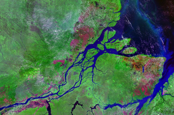
There are several larger islands in the mouth of the Amazon, but it is sometimes rather complex to describe which island is which. This source contains an image on page 33 called Mapa de Localização das ilhas de Caviana, Janaucu, Jurupari, Jarupari that is helpful, but it is probably non-free and (because it is based on a satellite image) sometimes difficult to read. Would it be possible have a Wikipedia-style map of the same area that contains the same labels? -- LeRoc (talk) 07:46, 22 May 2025 (UTC)
Thank you, that's a very good idea. I tried something here (I only put the name Outer Caviana for now). But it's hard to read the blueish text on the blue/green background. LeRoc (talk) 10:00, 22 May 2025 (UTC)
Thank you! Yes, I think this format would work. Important is that the labels can be put on there quite visibly. The thing is: the mouth of the Amazon is a very dynamic place. Islands break in two or join together, depending on the tides. This makes it difficult to name them and assert the shape and size of each island. We had a discussion here, where we decided that for an encyclopedia it makes the most sense to go by the definitions used by the Brazilian Institute of Geography and Statistics. Google Maps doesn't do this, so we can't refer to it to identify which island is which. I am hoping that this map will help to make things clear. LeRoc (talk) 19:49, 22 May 2025 (UTC)
The island you labelled as Janaucu needs to be split in two. There is a natural dividing line running North-South through the middle of the island. The left (Western) part is Inner Caviana, the right (Eastern) part is Janaucu.
The island you labelled as Caviana needs to be labelled Outer Caviana.
There is a small island that seems to be breaking off (Outer) Caviana, in the direction of Janaucu. This needs to be labelled Jarupari.
I'm sorry, but this is what the Brazilian Institute of Geography and Statistics says, and what we need to follow. Would that be possible? LeRoc (talk) 15:20, 23 May 2025 (UTC)
I do wonder what the right course of action is here. The IBGE map is from 2017 whereas the satellite image is from 2020. As of writing this (May 23rd 2025) the state of the islands look similar in a Google Maps satellite view as to what they did in the 2020 satellite view, so it's very possible that the islands have shifted since that official 2017 map was created. One potential solution could be to make one annotated map based on 2017 data and another based on 2020/2025 data so that you can show how the islands have shifted over time. The only issue would be finding a usable 2017 base map to avoid having to trace it all out in SVG. Didn't read the image decription properly and mixed up collect date with upload date, so the satellite image was actually taken on 2017. Not really sure how to consolidate the two sources then if the IBGE is saying one thing but satellite imagery is saying another. BaduFerreira (talk) 15:34, 23 May 2025 (UTC)
The problem may be that the satellite image was taken during low water, which joined the islands together? (I just want to get it right and write articles about these beautiful islands.) LeRoc (talk) 16:14, 23 May 2025 (UTC)
Now I feel a bit guilty for having "dragged" CMGlee into this. There is no fight between BaduFerreira and me, I think we both want to get this right. The question is, which of these images describes the island Caviana? My instincts tell me A, but according to the IBGE, official maps of Pará and academic papers based on their definitions, the correct answer is B. The island Caviana has split into two parts in 1850 (this is known), and apparently one of the parts is merging with the island Janaucu. I like the things that I wrote on the article Caviana, but it is important to get the shape and size of the island right. @BaduFerreira: how do we resolve this? I am thinking of taking it to the Village Pump of pt.wiki. Maybe that is an idea? LeRoc (talk) 14:08, 24 May 2025 (UTC)
No problem. Feel free to update my SVG accordingly.
If one can find an official map from the time of the islands' naming, we could draw outline of the original islands over a recent satellite view, similar to File:Caviana_AB.jpg? cmɢʟee⎆τaʟκ18:55, 24 May 2025 (UTC)
Thank you for your understanding :) Here is an official map by the Brazilian Ministry of Transport. If you zoom into the mouth of the Amazon, you can see the shape of the islands as they are officially defined. Also on the satellite image from 1990 I posted here, Inner Caviana and Janaucu are (still?) separate. LeRoc (talk) 20:30, 24 May 2025 (UTC)
@LeRoc: That might be tricky. Tracing the boundaries on a non-free map might be violating copyright, which if I remember correctly was the rationale for the creation of OpenStreetMap. I suppose tracing from an old satellite image is OK. cmɢʟee⎆τaʟκ10:55, 25 May 2025 (UTC)
I get that. Would you be able to trace the boundaries on the 1990 satellite image? Just of the islands in the mouth of the Amazon (the same area that is in the other images we posted here). LeRoc (talk) 12:29, 25 May 2025 (UTC)
Annotated 1990 satellite photograph of the Amazon delta
I've remade the SVG using the 1990 satellite photo as on the right. I had to zoom out as the resolution was too low to show detail. Is that better? cmɢʟee⎆τaʟκ00:14, 26 May 2025 (UTC)
This map seems to broken in some way. I would be grateful if someone could fix it, as it appears in four articles, two of them FAs. Thanks. Gog the Mild (talk) 16:31, 20 May 2025 (UTC)
@Isochrone Hi, thank you so much! I just have a few issues. (1) The name of the biggest island, Abemama, is absent. (2) Could you also distinguish the names between the islands and minor locations by, for example, capital letters or different color text? (3) Could you add the name of Kuria's other islet, Buariki, just for clarification? See Kuria (atoll). Thanks — VORTEX3427 (Talk!) 02:17, 28 May 2025 (UTC)


 Outdated Location Map of Angola. New additional border lines are needed: a) Cuando Cubango Province was split into two provinces. b) New Icolo e Bengo Province was separated from earlier much larger Luanda Province. c) Moxico Leste Province (i.e. East Moxico) was separated from Moxico Province.
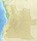 Relief locator with outdated administrative borders. Same corrections are needed as in previous map.
 Example of outdated location map of a province. Eastern part of this Moxico Province is now Moxico Leste. In practice, all 21 provinces need new location maps.


 Satellite image of Jeju
 Svg blank map
.svg)
 Satellite image
 SVG map

 Request taken. If you're thinking of a vector map (instead of a satellite photo), would something like http://openstreetmap.org#map=9/0/-51&layers=P do? cmɢʟee⎆τaʟκ 17:16, 22 May 2025 (UTC)
 :
:


 Done updating file description page. Please update any I've missed. Cheers, cmɢʟee⎆τaʟκ 10:10, 26 May 2025 (UTC)
 done
done