Várda
Appearance
Várda | |
|---|---|
Village | |
 Somssich-Matulay Mansion in Várda | |
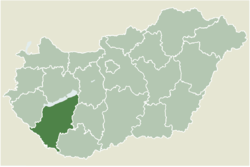
 Location of Somogy county in Hungary | |
| Coordinates: 46°27′43″N 17°44′33″E / 46.46202°N 17.74252°E | |
| Country | |
| Region | Southern Transdanubia |
| County | Somogy |
| District | Kaposvár |
| RC Diocese | Kaposvár |
| Area | |
• Total | 10.36 km2 (4.00 sq mi) |
| Population (2017) | |
• Total | 459[1] |
| Demonym | várdai |
| Time zone | UTC+1 (CET) |
| • Summer (DST) | UTC+2 (CEST) |
| Postal code | 7442 |
| Area code | (+36) 82 |
| NUTS 3 code | HU232 |
| MP | József Attila Móring (KDNP) |
| Website | Várda Online |
Várda is a village in Somogy county, Hungary.
History and Etymology
[edit]Várda was first mentioned in historical records in 1284 as a wilderness protected estate. By the 14th century, it had developed a parish.[2]The name Várda likely comes from the Hungarian word vár meaning “castle” or “fort,” with the suffix -da suggesting a place related to it, perhaps connotating “place of the fort.”[3]
Demographics
[edit]As of 2022, the population of Várda was 416. The general distribution towards males and females were 55% females and 45% males.[4]
| Year | 1980 | 1990 | 2001 | 2011 | 2022[4] |
|---|---|---|---|---|---|
| Population | 603 | 542 | 551 | 455 | 416 |
Notable people
[edit]- Endre Szász, a prominent Hungarian artist who lived and worked in Várda.[5]
External links
[edit]References
[edit]- ^ Várda, KSH
- ^ "Várda község története a kezdetektől | Várda Község Önkormányzata". varda.hu. Retrieved 2025-06-05.
- ^ "vár in Hungarian". kaikki.org. Retrieved 2025-06-06.
- ^ a b "Várda (Kaposvár, Somogy, Hungary) - Population Statistics, Charts, Map, Location, Weather and Web Information". www.citypopulation.de. Retrieved 2025-06-06.
- ^ "Kastélylátogatásra hív a várdai Szász-kúria | Várda Község Önkormányzata". www.varda.hu. Retrieved 2025-06-06.


