
User:Silverhelm/Maps
This page details maps that have been created by me and uploaded to Wikipedia.
Gallery of contributed maps
[edit]Maps of the Imperial Circles as at the beginning of the 16th century
[edit]These maps are also available in a German-language version; for details, see under the "List of contributed maps" section below.
Map with each of the circles indicated by a separate colour:
-
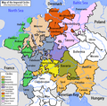 The Imperial Circles
-en.png)
Maps for individual circles:
-
 The Austrian Circle
(shown in orange) -
 The Bavarian Circle
(shown in brown) -
 The Burgundian Circle
(shown in green) -
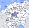
 The Electoral Rhenish Circle
(shown in grey-brown) -
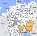
 The Franconian Circle
(shown in purple) -
 The Lower Rhenish-Westphalian Circle
(shown in light brown) -
 The Lower Saxon Circle
(shown in red) -
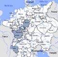
 The Swabian Circle
(shown in yellow) -
 The Upper Rhenish Circle
(shown in dark grey) -
 The Upper Saxon Circle
(shown in pink)


Maps of various countries of the world
[edit]
List of contributed maps
[edit]This list is in the chronological order of the original uploading of the English-language version of the file.
Colophon
[edit]Maps have been produced using Paint Shop Pro (version 7.02), with the aid of a Wacom Intuos 2 graphics tablet. Text is formatted using the Myriad Condensed Web font.
Licensing
[edit]| All maps created by me and uploaded to the English-language Wikipedia are licensed under the Creative Commons Attribution ShareAlike License 2.5. |
| Les droits de toutes mes images sont régis par la licence de Creative Commons «Paternité - Partage des conditions initiales à l'identique 2.5». |