User:Marmel2/sandbox
South Downtown | |
|---|---|
Downtown sub-district, urban residential and commercial | |
 Downtown Warsaw; South Downtown shown in red. | |
| Coordinates: 52°13′22.33″N 21°00′56.94″E / 52.2228694°N 21.0158167°E | |
| Country | |
| Voivodeship | Masovian |
| City and county | Warsaw |
| District | Downtown |
| Administrative neighbourhoods | Koszyki Krucza Oleandrów Powiśle-Solec |
| Elevation | 120 m (390 ft) |
| Time zone | UTC+1 (CET) |
| • Summer (DST) | UTC+2 (CEST) |
| Area code | +48 22 |
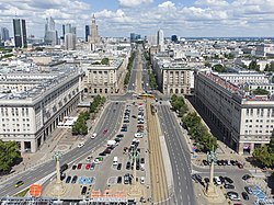
South Downtown (Polish: Śródmieście Południowe) is a central neighbourhood of Warsaw, Poland, located in the southern part of the city's Downtown district. It is characterized by a mix of residential, governmental, and institutional uses, with notable examples of prewar tenement architecture, postwar socialist realist housing, and modern high-rises.
Originally developed from several independent jurydyki (suburban towns) in the 18th century, the area became part of Warsaw in 1791. It was further urbanized in the 19th and early 20th centuries, particularly after the opening of the Vienna Station in 1845. During World War II, a portion of the area was designated by Nazi forces as the Police District, and later became a site of armed resistance during the Warsaw Uprising. Postwar reconstruction preserved much of the neighborhood's historic character while introducing new infrastructure and public space.
Today, South Downtown includes a range of civic, cultural, and educational institutions, and remains one of Warsaw's most architecturally diverse and administratively significant areas.
Geography and Boundaries
[edit]South Downtown is located in the southeastern part of the Downtown district (Śródmieście) of Warsaw, Poland. Its boundaries are roughly defined by Jerusalem Avenue to the north; Ujazdów Avenue, Piękna Street, and Szucha Avenue to the east; Batorego and Boya-Żeleńskiego Streets to the south; and Independence Avenue and Chałubińskiego Street to the west. It borders Mirów, North Downtown, Powiśle, Solec, Ujazdów, Old Mokotów, Filtry, and parts of the Wola and Ochota districts.
Administratively, South Downtown includes the neighbourhood councils of Koszyki, Krucza, Oleandrów, and Powiśle-Solec.[1][2]
Historically, the Żurawka River flowed through the area, originating from swamps near Sokrates Starynkiewicz Square and emptying into the Vistula River. In the 18th century, it was channeled underground, running beneath modern Żurawia Street, Three Crosses Square, Czerniakowska Street, and Okrąg Street. It was one of the most important waterways in southern Warsaw.[3][4]
History
[edit]Suburban origins and incorporation (pre-1791)
[edit]The area developed from several 18th-century suburban towns, or jurydyki, including Bożydar-Kałęczyn (1702), Bielino (1766), and Nowogrodzka (1767). These settlements were legally independent of Old Warsaw and exempt from its laws and taxes. Between 1768 and 1770, the Stanisław Axis was constructed, establishing a sequence of five urban squares that would define the district's layout.
In 1774, in Bożydar-Kałęczyn, then owned by August Kazimierz Sułkowski, the settlement of Nowa Jerozolima (lit. New Jerusalem) was founded and inhabited by the Jewish population. It was located between present-day Artur Zawisza Square and Kaliska Street. The neighborhood violated the royal edict banning Jews from settling within two miles of Old Warsaw. As a result, the city sued Sułkowski, and in 1776, the settlement was demolished, its residents expelled, and their properties confiscated.[5]
In 1770, the Lubomirski Ramparts were built around the southern edge of the city, incorporating the area. Tollhouses were installed at key crossings, including what is now Union of Lublin Square. By royal initiative, garden complexes and planned settlements such as Nowa Wieś were also established.
In 1791, under the Free Royal Cities Act, the suburban towns were formally incorporated into Warsaw, although implementation was delayed by political resistance until 1794.
Government Buildings
[edit]South Downtown houses many of Poland’s most significant government institutions, including:
- The Sejm and Senate Complex
- Ministry of Foreign Affairs
- Ministry of Infrastructure
- Ministry of National Education
- Ministry of Justice
- Ministry of Economic Development and Technology
- Central Statistical Office
- Financial Supervision Authority
- National Development Bank
Transportation
[edit]The Politechnika metro station of the M1 line of the Warsaw Metro lies within the neighborhood. South Downtown also includes tram, bus, and historically important rail infrastructure, such as the former Vienna Station and narrow-gauge rail networks.
Religion
[edit]South Downtown includes several historic Roman Catholic churches:
- Church of the Holiest Saviour
- St. Alexander Church
- St. Peter and St. Paul's Church
- Chapel of Our Lady of Perpetual Help
- St. Barbara Chapel
- Chapel of the Divine Mercy of the Polish-Catholic Church of the Republic of Poland
References
[edit]- ^ Cite error: The named reference
os1was invoked but never defined (see the help page). - ^ Cite error: The named reference
os2was invoked but never defined (see the help page). - ^ Encyklopedia Warszawy, 1994, p. 1034.
- ^ Drozdowski & Zahorski, Historia Warszawy, 2004, p. 8.
- ^ Cite error: The named reference
zielwas invoked but never defined (see the help page).


