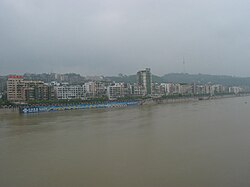
Tuo River
Appearance
| Tuo River | |
|---|---|
 Tuo River in Luzhou | |
 | |
| Location | |
| China | |
| Physical characteristics | |
| Source | |
| • location | Ta'ershan, Sichuan |
| • elevation | 2,560 m (8,400 ft) |
| Mouth | Yangtze River |
| Length | 655 km (407 mi) |
| Basin size | 32,900 km2 (12,700 sq mi) |
| Discharge | |
| • average | 1,000 m3/s (35,000 cu ft/s) |
The Tuo River (Chinese: 沱江; pinyin: Tuó Jiāng) is 655-kilometer (407 mi)-long river in Sichuan province of southern China.
The Tuo River is one of the major tributaries of the upper Yangtze River (Chang Jiang).
Geography
[edit]The river originates at the northwest edge of Sichuan basin. It flows through Jintang, Jianyang, Ziyang, Zizhong, and Neijiang.
It flows into Yangtze River in Luzhou, Sichuan.
See also
[edit]References
[edit]Wikimedia Commons has media related to Tuo River.
