
Trou au Natron

Trou au Natron (French: "hole of natron") or Doon Orei (Teda: "big hole")[1] is a volcanic caldera of the Tibesti Massif in the nation of Chad in Northern Africa.[2][3] The volcano is extinct. It is unknown when it last erupted.[4][5] Its volcano number is 0205–01.[6] Trou au Natron is located just south-east of Toussidé, the westernmost volcano of the Tibesti Mountains. Its edge cuts into the nearby Yirrigue caldera.

Geology
[edit]The caldera sits at an elevation of 2,450 m (8,040 ft).[7] It has an irregular diameter of approximately 6–8 km (4–5 mi) and is up to 1,000 m (3,300 ft) deep.[2] Four smaller volcanic cones, made of scoria or andesitic tuff sit on the floor of the caldera.[2][8] Numerous smaller vents and hot springs on the caldera's floor emit hot steam and mineral water.[2]
Because of its irregular shape, it has been theorized that the caldera was formed as a result of multiple massive explosions, each of which deepened the enormous pit.[2] During these explosions, chunks of debris up to 5 m3 (180 cu ft) in size may have been hurled up to 10 km (6.2 mi) from the crater.[2] Its exact period of formation is unconfirmed, although a Pleistocene formation has been suggested.[6] It is known to be one of the youngest formations on the Tibesti Massif.[4]
Much of the surface of the caldera is lined with a white crust of carbonate salts such as sodium carbonite and natrolite.[8] This substance is also known as natron, leading to the French name for the site. This crust is sometimes known as the Tibesti Soda Lake.[2][9] The crusts are formed when mineral-rich steam is emitted from small vents on the crater's floor. When this water evaporates in the desert heat, the minerals remain behind as part of the crust.[2]
Both the slopes and the floor of the caldera contain thick layers of fossilized aquatic gastropods and diatoms, indicating that the caldera was once home to a deep lake. During the Last Glacial Maximum, the lake may have been up to 500 m (1,600 ft) deep. Radiocarbon dating on some of these samples indicates an age of approximately 14,500–15,000 years Before Present.[10]
Gallery
[edit]-
 Satellite image of Trou au Natron via Advanced Spaceborne Thermal Emission and Reflection Radiometer (ASTER)
 -
 Satellite image of the Tousside volcano (large dark area in centre). Trou au Natron is visible below and to the right (smaller white area).
 -
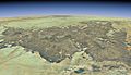 Satellite overview of the Tibesti Massif. Trou au Natron is located to the left; it is highlighted in the full-size view of the image.
 -
 Overview of Trou au Natron's caldera from its summit.
_ASTER.jpg)


References
[edit]- ^ Beltrami, Vanni; Proto, Harry (2007). Il Sahara centro-orientale dalla preistoria ai tempi dei nomadi Tubu (in Italian). Archaeopress. ISBN 9781407301020.
- ^ a b c d e f g h Scheffel, Richard L.; Wernet, Susan J., eds. (1980). Natural Wonders of the World. United States of America: Reader's Digest Association, Inc. p. 377. ISBN 0-89577-087-3.
- ^ al-Arḍ, Jamʻīyah al-Lībīyah li-ʻUlūm (1966). Annual Field Conference. Earth Sciences Society of the Libyan Arab Republic.
The Trou au Natron has a caldera diameter of six to eight km...
- ^ a b "Tarso Toussidé". Global Volcanism Program. Smithsonian Institution. Retrieved 3 October 2017.
- ^ "VOGRIPA". www.bgs.ac.uk. Archived from the original on 3 October 2017. Retrieved 3 October 2017.
- ^ a b Siebert, Lee; Simkin, Tom; Kimberly, Paul (9 February 2011). Volcanoes of the World: Third Edition. University of California Press. ISBN 9780520947931.
- ^ Barry, Roger Graham (1981). Mountain Weather and Climate. CUP Archive. ISBN 9780416737301.
- ^ a b Green, Jack; Short, Nicholas Martin (6 December 2012). Volcanic Landforms and Surface Features: A Photographic Atlas and Glossary. Springer Science & Business Media. ISBN 9783642651502.
- ^ Goudie, Andrew (2002). Great Warm Deserts of the World: Landscapes and Evolution. Oxford University Press. ISBN 9780199245154.
- ^ Soulié-Märsche, I.; Bieda, S.; Lafond, R.; Maley, J.; M'Baitoudji; Vincent, P. M.; Faure, Hugues (1 July 2010). "Charophytes as bio-indicators for lake level high stand at "Trou au Natron", Tibesti, Chad, during the Late Pleistocene". Global and Planetary Change. Quaternary and Global Change: Review and Issues Special issue in memory of Hugues FAURE. 72 (4): 335. Bibcode:2010GPC....72..334S. doi:10.1016/j.gloplacha.2010.05.004. ISSN 0921-8181.