Tom, Oklahoma
Appearance
Tom, Oklahoma | |
|---|---|
 | |
| Coordinates: 33°44′09″N 94°34′23″W / 33.73583°N 94.57306°W[1] | |
| Country | United States |
| State | Oklahoma |
| County | McCurtain |
| Elevation | 371 ft (113 m) |
| Time zone | UTC-6 (Central (CST)) |
| • Summer (DST) | UTC-5 (CDT) |
| ZIP codes | 74740 |
| GNIS feature ID | 1101695[1] |

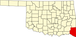
Tom is an unincorporated small rural village in McCurtain County, Oklahoma, United States. It is the second-southeasternmost community in Oklahoma, in the midst of the Ouachita National Forest. At Tom, there are two churches, a food store, a senior center, a park, and a fire station, plus several homes. There is no gasoline station, public lodgings, medical service, post office, or other businesses or services.
History
[edit]The village was named for Tom Stewart, an early settler. A post office was established at Tom in 1916.
References
[edit]- ^ a b c "Tom". Geographic Names Information System. United States Geological Survey, United States Department of the Interior. Retrieved April 18, 2024.


