Thelma, Texas
Appearance
Thelma, Texas | |
|---|---|
| Coordinates: 29°12′51″N 98°30′6″W / 29.21417°N 98.50167°W | |
| Country | United States |
| State | Texas |
| County | Bexar |
| Elevation | 574 ft (175 m) |
| Time zone | UTC-6 (Central (CST)) |
| • Summer (DST) | UTC-5 (CDT) |
| Area code(s) | 210, 726 |
| GNIS feature ID | 1380654[1] |
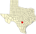
Thelma is an unincorporated community in Bexar County, in the U.S. state of Texas.[1] According to the Handbook of Texas, the community had a population of 45 in 2000. It is located within the Greater San Antonio metropolitan area.
History
[edit]Established around the turn of the twentieth century, and with a post-office built in 1906, Thelma became a station on the an Antonio, Uvalde and Gulf Railroad in 1912. In the 1940s, the community had four dairies. After World War II, the town's population declined.[2]
| Year | 1914 | 1940 | 2000 |
|---|---|---|---|
| Population | 300 | 25 | 45 |
Geography
[edit]Thelma is located at the intersection of Texas State Highway Loop 1604 and the Southern Pacific Railroad, 15 mi (24 km) south of Downtown San Antonio in southern Bexar County.[2]
Education
[edit]Thelma is served by the Southside Independent School District.
References
[edit]- ^ a b c U.S. Geological Survey Geographic Names Information System: Thelma, Texas
- ^ a b c Long, Christopher. "Thelma, TX (Bexar County)". tshaonline.org. Retrieved August 13, 2022.


