
Schwarzenbach am Wald
Schwarzenbach a.Wald | |
|---|---|
 Lutheran Church of Jesus | |
 Coat of arms | |
Location of Schwarzenbach a.Wald within Hof district 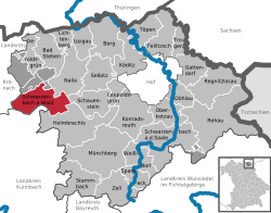 | |
 Schwarzenbach a.Wald  Schwarzenbach a.Wald | |
| Coordinates: 50°17′0″N 11°37′15″E / 50.28333°N 11.62083°E | |
| Country | Germany |
| State | Bavaria |
| Admin. region | Oberfranken |
| District | Hof |
| Subdivisions | 39 Ortsteile |
| Government | |
| • Mayor (2018–24) | Reiner Feulner[1] (CSU) |
| Area | |
• Total | 36.50 km2 (14.09 sq mi) |
| Elevation | 686 m (2,251 ft) |
| Population (2024-12-31)[2] | |
• Total | 4,231 |
| • Density | 120/km2 (300/sq mi) |
| Time zone | UTC+01:00 (CET) |
| • Summer (DST) | UTC+02:00 (CEST) |
| Postal codes | 95131 |
| Dialling codes | 09289 |
| Vehicle registration | HO |
| Website | www.schwarzenbach-wald.de |
Schwarzenbach am Wald is a town in the district of Hof, in Bavaria, Germany. It is situated 21 km west of Hof, and 23 km northeast of Kulmbach.
Geography
[edit]Geographical situation
[edit]Schwarzenbach am Wald is situated in a natural environment at the bottom of the Döbraberg in the Frankenwald natural park.
City structure
[edit]
|
|
|
References
[edit]- ^ Liste der ersten Bürgermeister/Oberbürgermeister in kreisangehörigen Gemeinden, Bayerisches Landesamt für Statistik, accessed 19 July 2021.
- ^ "Gemeinden, Kreise und Regierungsbezirke in Bayern, Einwohnerzahlen am 31. Dezember 2024; Basis Zensus 2022" [Municipalities, counties, and administrative districts in Bavaria; Based on the 2022 Census] (CSV) (in German). Bayerisches Landesamt für Statistik.
Towns and municipalities in Hof (district) | ||
|---|---|---|
|  | |
| International | |
|---|---|
| National | |
| Geographic | |
This Hof district location article is a stub. You can help Wikipedia by expanding it. |