
SHIA railway station
A05 SHIA Station Soekarno–Hatta International Airport Station Stasiun Bandara Soekarno–Hatta | |||||||||||
|---|---|---|---|---|---|---|---|---|---|---|---|
 West view | |||||||||||
| General information | |||||||||||
| Location | Between Soekarno–Hatta International Airport Terminal 1 & Terminal 2 Banten Indonesia | ||||||||||
| Coordinates | 6°07′39″S 106°39′08″E / 6.127382°S 106.652205°E | ||||||||||
| Owned by | Kereta Api Indonesia | ||||||||||
| Operated by | KAI Bandara (2017-2022) KAI Commuter (2023-present) | ||||||||||
| Line(s) | |||||||||||
| Platforms | 2 island platforms | ||||||||||
| Tracks | 4 | ||||||||||
| Construction | |||||||||||
| Structure type | Ground | ||||||||||
| Parking | |||||||||||
| Accessible | |||||||||||
| Other information | |||||||||||
| Station code | BST | ||||||||||
| IATA code | CGK | ||||||||||
| Classification | Class I[1] | ||||||||||
| History | |||||||||||
| Opened | 26 December 2017[2] | ||||||||||
| Services | |||||||||||
| |||||||||||
| |||||||||||

SHIA Station or Soekarno–Hatta International Airport Station (BST) (Indonesian: Stasiun Bandara Soekarno–Hatta) is a railway station within the Soekarno–Hatta International Airport complex in Tangerang, Banten, Indonesia, serving the Soekarno–Hatta Airport Rail Link and inter-terminal airport skytrain. It is located between the airport's Terminal 1 to the south and Terminal 2 to the north.[3]
This station serves airport passengers going to Batu Ceper Station, Duri Station, BNI City Station, to Manggarai Station.[4][5][6] The station began serving passengers on 26 December 2017 and was inaugurated on 2 January 2018.
Building and layout
[edit]
SHIA station is nestled in an integrated building, which can accommodate about 3500 passengers.[7] The station has two platforms, both equipped with full-height platform screen doors. There are a passenger lobby, four escalators and two elevators placed across the terminal building. The station is equipped with facilities such as ticket counters (only Debit or Credit Card is acceptable), public spaces, electronic gates, waiting rooms, commercial rooms, restrooms, prayer rooms, the rail administrator room, and a skytrain station.[7][8] The station yard can accommodate four trains of 10 carriages.
The ground floor of the building is fully used for the Soekarno-Hatta Airport rail link station. The airport skytrain station is located on the upper level.[7] The ARS emplacement has four lines, with lines 2 and 3 are straight tracks.
| Station Hall | Line 1 | |
| Bay platform | ||
| Line 2 | ||
| Line 3 | ||
| Bay platform | ||
| Line 4 | ||
Services
[edit]Passenger services
[edit]Airport rail link
[edit]| Train line name | Destination | Notes |
|---|---|---|
| Manggarai | - | |
| SHIA |
Airport skytrain
[edit] Airport Skytrain to Terminal 1, 2, and 3.
Supporting transportation
[edit]Buses
[edit]| System | Route | Destination | Notes |
|---|---|---|---|
| Transjakarta | Kalideres Terminal–Perkantoran Soekarno–Hatta | The final terminus is located at the airport office complex near the station (hence the name 'Perkantoran Soekarno–Hatta').
The route does not stop at all three passenger terminals, but a shuttle service is provided to connect the route with the terminals. | |
| Shuttle bus service | Free | TOD M1—ACS—T2—Stasiun KA Bandara—Bundaran Kargo—Terminal 3—Terminal 1—ACD—TOD M1 | The free service route utilize Transjakarta's premium service fleet called 'Royaltrans.' |
| Paid | TOD M1—ACS—MPS—T2—Parkir Inap 1—Stasiun KA Bandara—Imigrasi—Terminal Kargo—Terminal 3—Terminal 1—ACD—TOD M1 | The paid service route is operating with bus fleets owned by Big Bird, a subsidary of the national taxicab company Bluebird Group |
Incidents
[edit]- On 5 February 2018, This station was temporarily closed considering that there was a landslide around the airport which caused the airport rail link to temporarily stop operating.[9] The airport rail link service was restored three days later on 8 February 2018.[10]
Gallery
[edit]-
 The building seen from the airport skytrain
 -
 Interior of the station
 -
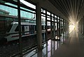 The platform area
.jpg)
.jpg)

See also
[edit]References
[edit]- ^ Buku Informasi Direktorat Jenderal Perkeretaapian 2014 (PDF) (in Indonesian).
- ^ "Jakarta airport rail link opens, proves a hit with travellers". Straits Times. 31 December 2017. Retrieved 11 March 2018.
- ^ "Stasiun Bandara Soekarno-Hatta 95 Persen, Begini Kondisinya". Kompas (in Indonesian). Retrieved 1 December 2017.
- ^ Andri Donnal Putera (23 May 2017). "Rute Kereta Api Bandara Soekarno-Hatta" (in Indonesian). Kompas.com. Retrieved 19 March 2023.
- ^ Muhammad Idris (11 April 2017). "Ini Daftar Stasiun yang Dilewati Kereta Bandara Soetta" (in Indonesian). detikFinance. Retrieved 19 March 2023.
- ^ Hasan Kurniawan (24 April 2017). "Ini Jalur Menuju Stasiun Kereta Api Bandara Soetta" (in Indonesian). Sindonews.com. Retrieved 19 March 2023.
- ^ a b c Chandra, Ardan Adhi (17 September 2017). "Diresmikan 2 Menteri, Skytrain Bandara Soetta Mulai Beroperasi". detikfinance (in Indonesian). Retrieved 19 March 2023.
- ^ "Soekarno-Hatta Airport Train to Be Operational in July". Jakarta Globe. Archived from the original on 22 July 2020. Retrieved 1 December 2017.
- ^ Pitoko, Ridwan Aji (5 February 2018). "Tembok Perimeter Selatan Ambrol, Kereta Bandara Berhenti Operasi". KOMPAS.com (in Indonesian). Retrieved 19 March 2023.
- ^ Pitoko, Ridwan Aji (8 February 2018). "Kereta Bandara Kembali Beroperasi". KOMPAS.com (in Indonesian). Retrieved 19 March 2023.
External links
[edit] Media related to Soekarno-Hatta International Airport Station at Wikimedia Commons
| Preceding station | Kereta Api Indonesia | Following station | ||
|---|---|---|---|---|
| Batu Ceper Terminus |
BPR–BST | Terminus |
| Terminals |
| ||||
|---|---|---|---|---|---|
| Airline hubs | |||||
| Transport |
| ||||
| Authorities and operators | |||||