
Olevsk
Olevsk
Олевськ | |
|---|---|
 Downtown Olevsk | |
 Flag  Coat of arms | |
 Olevsk  Olevsk | |
| Coordinates: 51°13′N 27°39′E / 51.217°N 27.650°E | |
| Country | |
| Oblast | Zhytomyr Oblast |
| Raion | Korosten Raion |
| Hromada | Olevsk urban hromada |
| Population (2022) | |
• Total | 10,032 |
| Time zone | UTC+2 (EET) |
| • Summer (DST) | UTC+3 (EEST) |
Olevsk (Ukrainian: Олевськ, IPA: [oˈlɛu̯sʲk] ⓘ; Polish: Olewsk; Yiddish: אלעווסק) is a city in Korosten Raion, Zhytomyr Oblast, Ukraine, administrative center of Olevsk urban hromada. As of January 2022 its population was approximately 10,032.[1] Olevsk is located in Zhytomyr Polissya.
History
[edit] Grand Duchy of Lithuania (1488–1569)
 Polish–Lithuanian Commonwealth (1569–1793)
 Russian Empire (1793–1917)
 Ukrainian People's Republic (1917–1918)
 Ukrainian State (1918)
- Ukrainian People's Republic (1918–1919)
 Republic of Poland (1919–1920)[citation needed]
 Soviet Ukraine (1920–1922)
 Soviet Union (1922–1991)
 Nazi Germany (1941–1944) (occupation)
- Ukraine (1991–present)
Olevsk was first mentioned in 1488. In 1641 Olevsk was granted Magdeburg city rights by Polish King Władysław IV Vasa. Later it became a town in Volhynian Governorate of the Russian Empire.[2]
During World War II on November 15 or 21, 1941, members of Taras Bulba-Borovets' Ukrainian People's Revolutionary Army collaborated with the German administration in taking more than 500 Jews from Olevsk to Varvarivka, where they were murdered.[3]
On December 25, 2011, the city council of Olevsk renamed the streets of the city that bore the names of Soviet leaders, naming them in honor of prominent figures of the Ukrainian nationalist and patriotic movement. The streets and lanes named after Pavlo Postyshev, Stanislav Kosior, Hryhoriy Petrovsky, Mykhailo Kalinin, and Hryhoriy Kotovsky were renamed. Instead, they were named after Olena Teliha, Oleh Olzhych, Hetman Vyhovsky, Oleksiy Opanasiuk, Heroes of Kruty, the 20th anniversary of Ukraine's independence, and Yuriy Tiutiunnyk.[4]
Geography
[edit]Olevsk is located in the north-west of Korosten District of Zhytomyr Oblast, 180 km from the regional center. The city is located on the Polesian Lowland, in Zhytomyr Polissya .[5] [6] Mixed forests, swamps and lakes occur around the city. Pine, hornbeam and oak are most often found in the forests. The city is located on the right bank of the Pripyat River, a right tributary of the Dnieper River. The climate of the territory is moderately continental, with humid summers and mild winters. The average annual temperature is about 10 ° C, the average temperature in January is 4-5 ° C, and in July it is about + 20 ° C. The annual amount of precipitation is 570 mm. [7][6] The European highway E373 passes south of Olevsk.[8]
Gallery
[edit]-
 Ubort River in Olevsk
 -
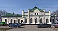 Olevsk railway station
 -
 Saint Nicholas monument
 -
 St. Nicholas Church


References
[edit]- ^ Чисельність наявного населення України на 1 січня 2022 [Number of Present Population of Ukraine, as of January 1, 2022] (PDF) (in Ukrainian and English). Kyiv: State Statistics Service of Ukraine. Archived (PDF) from the original on 4 July 2022.
- ^ Юрій Халімончук. "Історія міста Олевськ". Олевська ТГ (in Ukrainian). Retrieved 2025-07-05.
- ^ McBride, Jared. "Ukrainian Holocaust Perpetrators Are Being Honored in Place of Their Victims". The Tablet. Retrieved 2016-05-20.
- ^ "На Житомирщині перейменували всі радянські назви вулиць - Новини - Ukranews". ukranews.com (in Ukrainian). Archived from the original on 2014-03-20. Retrieved 2025-07-05.
- ^ Житомирська область: географічний атлас. Вид. 5-е, випр. і допов. / відпов. ред. М. Ю. Костриця. Київ: ТОВ «Вид-во «Мапа», 2012. 23 с. Retrieved 2025-06-26
- ^ a b Регіональна доповідь про стан навколишнього природного середовища в Житомирській області за 2021 Житомирська обласна військова адміністрація Retrieved 2025-06-26
- ^ Костриця М. Ю. Географія Житомирської області. Ж., 1993. Retrieved 2025-06-26
- ^ Постанова Кабінету Міністрів України від 30 січня 2019 року № 55 «Про затвердження переліку автомобільних доріг загального користування державного значення» Retrieved 2025-06-24