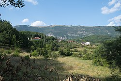
Nerezi
This article needs additional citations for verification. (November 2013) |
Nerezi
Нерези | |
|---|---|
Village | |
 Panoramic view of the village | |
| Coordinates: 41°20′22″N 20°36′11″E / 41.33944°N 20.60306°E | |
| Country | |
| Region | |
| Municipality | |
| Elevation | 870 m (2,850 ft) |
| Population (2002) | |
• Total | 213 |
| Time zone | UTC+1 (CET) |
| • Summer (DST) | UTC+2 (CEST) |
| Car plates | SU |
| Website | . |
Nerezi (Macedonian: Нерези) is a village in North Macedonia, located in the Struga municipality near in the Drimkol region.[1]
History
[edit]Nerezi (Nizazi) is recorded in the Ottoman defter of 1467 as a village in the vilayet of Dulgobrda. The settlement had a total of 6 households with the anthroponymy attested mostly being Slavic in character with Albanian anthroponyms only being present in 1 (e.g., Mirush Duriz).[2] Nerezi (Nerec) is again recorded in the Ottoman defter of 1583 as a village in the vilayet of Dulgobrda. The settlement had a total of 26 households with the anthroponymy attested being mostly Slavic in character, with Albanian anthroponyms forming a minority as well as displaying instances of Slavicisation (e.g., Petko Gjon-i, Gjorgo Gjergj, Petko Kurte etc.).[3]
Demographics
[edit]The village is populated by 213 inhabitants of whom 212 are Macedonians. Today there are around hundred of houses and around hundred and twenty inhabitants living in the village.
References
[edit]- ^ "Google Maps".
- ^ Gjoni, Z. & Përnezha, H. (2011). Dibra në Defterët Osmanë (1467, 1583), f.108. Tiranë: Botime M&B page 295
- ^ Gjoni, Z. & Përnezha, H. (2011). Dibra në Defterët Osmanë (1467, 1583), f.108. Tiranë: Botime M&B page 303

