
Metro B Line (Minnesota)
| Metro B Line | ||||||||||||||||||||||||||||||||||||||||||||||||||||||||||||||||||||||||||||||||||||||||||||||||||||||||||||||||||||||||||||||||||||||||||||||||||||||||||||||||||||||||||||||||||||||||||||||||||||||||||||||||||||||||||||||||||||||||||||||||||||||||||||||||||||||||||||||||||||||||||||||||||||||||||||||||||||||||
|---|---|---|---|---|---|---|---|---|---|---|---|---|---|---|---|---|---|---|---|---|---|---|---|---|---|---|---|---|---|---|---|---|---|---|---|---|---|---|---|---|---|---|---|---|---|---|---|---|---|---|---|---|---|---|---|---|---|---|---|---|---|---|---|---|---|---|---|---|---|---|---|---|---|---|---|---|---|---|---|---|---|---|---|---|---|---|---|---|---|---|---|---|---|---|---|---|---|---|---|---|---|---|---|---|---|---|---|---|---|---|---|---|---|---|---|---|---|---|---|---|---|---|---|---|---|---|---|---|---|---|---|---|---|---|---|---|---|---|---|---|---|---|---|---|---|---|---|---|---|---|---|---|---|---|---|---|---|---|---|---|---|---|---|---|---|---|---|---|---|---|---|---|---|---|---|---|---|---|---|---|---|---|---|---|---|---|---|---|---|---|---|---|---|---|---|---|---|---|---|---|---|---|---|---|---|---|---|---|---|---|---|---|---|---|---|---|---|---|---|---|---|---|---|---|---|---|---|---|---|---|---|---|---|---|---|---|---|---|---|---|---|---|---|---|---|---|---|---|---|---|---|---|---|---|---|---|---|---|---|---|---|---|---|---|---|---|---|---|---|---|---|---|---|---|---|---|---|---|---|---|---|---|---|---|---|---|---|---|---|---|---|---|---|---|---|---|---|---|---|---|---|---|---|---|---|---|---|---|---|---|---|---|
 Aerial view of the B Line station at 31st Avenue | ||||||||||||||||||||||||||||||||||||||||||||||||||||||||||||||||||||||||||||||||||||||||||||||||||||||||||||||||||||||||||||||||||||||||||||||||||||||||||||||||||||||||||||||||||||||||||||||||||||||||||||||||||||||||||||||||||||||||||||||||||||||||||||||||||||||||||||||||||||||||||||||||||||||||||||||||||||||||
| Overview | ||||||||||||||||||||||||||||||||||||||||||||||||||||||||||||||||||||||||||||||||||||||||||||||||||||||||||||||||||||||||||||||||||||||||||||||||||||||||||||||||||||||||||||||||||||||||||||||||||||||||||||||||||||||||||||||||||||||||||||||||||||||||||||||||||||||||||||||||||||||||||||||||||||||||||||||||||||||||
| System | Metro | |||||||||||||||||||||||||||||||||||||||||||||||||||||||||||||||||||||||||||||||||||||||||||||||||||||||||||||||||||||||||||||||||||||||||||||||||||||||||||||||||||||||||||||||||||||||||||||||||||||||||||||||||||||||||||||||||||||||||||||||||||||||||||||||||||||||||||||||||||||||||||||||||||||||||||||||||||||||
| Operator | Metro Transit | |||||||||||||||||||||||||||||||||||||||||||||||||||||||||||||||||||||||||||||||||||||||||||||||||||||||||||||||||||||||||||||||||||||||||||||||||||||||||||||||||||||||||||||||||||||||||||||||||||||||||||||||||||||||||||||||||||||||||||||||||||||||||||||||||||||||||||||||||||||||||||||||||||||||||||||||||||||||
| Garage | East Metro | |||||||||||||||||||||||||||||||||||||||||||||||||||||||||||||||||||||||||||||||||||||||||||||||||||||||||||||||||||||||||||||||||||||||||||||||||||||||||||||||||||||||||||||||||||||||||||||||||||||||||||||||||||||||||||||||||||||||||||||||||||||||||||||||||||||||||||||||||||||||||||||||||||||||||||||||||||||||
| Vehicle | New Flyer XD60 | |||||||||||||||||||||||||||||||||||||||||||||||||||||||||||||||||||||||||||||||||||||||||||||||||||||||||||||||||||||||||||||||||||||||||||||||||||||||||||||||||||||||||||||||||||||||||||||||||||||||||||||||||||||||||||||||||||||||||||||||||||||||||||||||||||||||||||||||||||||||||||||||||||||||||||||||||||||||
| Status | Operational | |||||||||||||||||||||||||||||||||||||||||||||||||||||||||||||||||||||||||||||||||||||||||||||||||||||||||||||||||||||||||||||||||||||||||||||||||||||||||||||||||||||||||||||||||||||||||||||||||||||||||||||||||||||||||||||||||||||||||||||||||||||||||||||||||||||||||||||||||||||||||||||||||||||||||||||||||||||||
| Predecessors | 21, 53, Selby-Lake Streetcar | |||||||||||||||||||||||||||||||||||||||||||||||||||||||||||||||||||||||||||||||||||||||||||||||||||||||||||||||||||||||||||||||||||||||||||||||||||||||||||||||||||||||||||||||||||||||||||||||||||||||||||||||||||||||||||||||||||||||||||||||||||||||||||||||||||||||||||||||||||||||||||||||||||||||||||||||||||||||
| Route | ||||||||||||||||||||||||||||||||||||||||||||||||||||||||||||||||||||||||||||||||||||||||||||||||||||||||||||||||||||||||||||||||||||||||||||||||||||||||||||||||||||||||||||||||||||||||||||||||||||||||||||||||||||||||||||||||||||||||||||||||||||||||||||||||||||||||||||||||||||||||||||||||||||||||||||||||||||||||
| Route type | Bus rapid transit | |||||||||||||||||||||||||||||||||||||||||||||||||||||||||||||||||||||||||||||||||||||||||||||||||||||||||||||||||||||||||||||||||||||||||||||||||||||||||||||||||||||||||||||||||||||||||||||||||||||||||||||||||||||||||||||||||||||||||||||||||||||||||||||||||||||||||||||||||||||||||||||||||||||||||||||||||||||||
| Locale | Minneapolis–St. Paul, Minnesota | |||||||||||||||||||||||||||||||||||||||||||||||||||||||||||||||||||||||||||||||||||||||||||||||||||||||||||||||||||||||||||||||||||||||||||||||||||||||||||||||||||||||||||||||||||||||||||||||||||||||||||||||||||||||||||||||||||||||||||||||||||||||||||||||||||||||||||||||||||||||||||||||||||||||||||||||||||||||
| Start | Lake & France Station | |||||||||||||||||||||||||||||||||||||||||||||||||||||||||||||||||||||||||||||||||||||||||||||||||||||||||||||||||||||||||||||||||||||||||||||||||||||||||||||||||||||||||||||||||||||||||||||||||||||||||||||||||||||||||||||||||||||||||||||||||||||||||||||||||||||||||||||||||||||||||||||||||||||||||||||||||||||||
| Via | Lake Street, Selby Avenue | |||||||||||||||||||||||||||||||||||||||||||||||||||||||||||||||||||||||||||||||||||||||||||||||||||||||||||||||||||||||||||||||||||||||||||||||||||||||||||||||||||||||||||||||||||||||||||||||||||||||||||||||||||||||||||||||||||||||||||||||||||||||||||||||||||||||||||||||||||||||||||||||||||||||||||||||||||||||
| End | Union Depot Station | |||||||||||||||||||||||||||||||||||||||||||||||||||||||||||||||||||||||||||||||||||||||||||||||||||||||||||||||||||||||||||||||||||||||||||||||||||||||||||||||||||||||||||||||||||||||||||||||||||||||||||||||||||||||||||||||||||||||||||||||||||||||||||||||||||||||||||||||||||||||||||||||||||||||||||||||||||||||
| Length | 13 mi (21 km) | |||||||||||||||||||||||||||||||||||||||||||||||||||||||||||||||||||||||||||||||||||||||||||||||||||||||||||||||||||||||||||||||||||||||||||||||||||||||||||||||||||||||||||||||||||||||||||||||||||||||||||||||||||||||||||||||||||||||||||||||||||||||||||||||||||||||||||||||||||||||||||||||||||||||||||||||||||||||
| Stations | 34 (7 one-way station pairs) | |||||||||||||||||||||||||||||||||||||||||||||||||||||||||||||||||||||||||||||||||||||||||||||||||||||||||||||||||||||||||||||||||||||||||||||||||||||||||||||||||||||||||||||||||||||||||||||||||||||||||||||||||||||||||||||||||||||||||||||||||||||||||||||||||||||||||||||||||||||||||||||||||||||||||||||||||||||||
| ||||||||||||||||||||||||||||||||||||||||||||||||||||||||||||||||||||||||||||||||||||||||||||||||||||||||||||||||||||||||||||||||||||||||||||||||||||||||||||||||||||||||||||||||||||||||||||||||||||||||||||||||||||||||||||||||||||||||||||||||||||||||||||||||||||||||||||||||||||||||||||||||||||||||||||||||||||||||
The Metro B Line is a bus rapid transit route in the Minneapolis–Saint Paul region of Minnesota, operated by Metro Transit as part of the Metro network. The route began operation in June 2025, connecting Saint Paul Union Depot to Bde Maka Ska in the Uptown neighborhood of Minneapolis, via Lake Street and Selby Avenue. The B Line succeeds Metro Transit's Route 21, adding transit signal priority, bus lanes, and all-door boarding to provide faster and higher quality service.[2][3]
Lake Street and Selby Avenue have formed an important east-west travel corridor since the early 20th century. The corridor was served by streetcars until the 1950s, and has been served by buses since. Planning for the B Line began in 2014, and full funding for construction was secured in 2020. Construction began in 2023, and progressed through the 2023 and 2024 construction seasons. The line opened to the public as scheduled on June 14, 2025, although its opening ceremony was cancelled due to security concerns following the shootings of multiple Minnesota legislators earlier that day.[4]
Background
[edit]
The corridor has a long history of transit service. The Twin City Rapid Transit Company operated a streetcar on Selby Avenue and Lake Street starting in 1906.[5] Once the streetcars were replaced in the 1950s with buses, a bus route continued to operate over the route. Route 21 served the corridor from Uptown Transit Center to the Union Depot in downtown Saint Paul.[6]
Buses on the corridor formerly traveled on the National Register of Historic Places-listed Selby Avenue Bridge over Ayd Mill Road. When the bridge was in the process of being replaced in 1993, buses were detoured a half mile north to University Avenue. Increased ridership led Metro Transit to leave the detour in place following completion of the replacement bridge.[7]
In 2011 and 2012, Metro Transit studied eleven urban transit corridors to be upgraded with enhanced bus improvements. Other corridors identified in the study included Snelling Avenue, Penn Avenue, and Chicago Avenue, which are currently in operation as the Metro A, C, and D Lines respectively.[8]
Route 21 served over 10,000 passengers per weekday in 2019, which made it Metro Transit's second-busiest route.[6] A limited-stop bus, Route 53, operated during peak periods offering limited stop service along Lake Street and Marshall Avenue before traveling on I-94 to downtown Saint Paul. Average speeds for Route 21 and 53 were 10 and 13.2 miles per hour respectively in 2019, which made Route 21 one of the slowest routes in the Twin Cities.[6] In May 2019, the B Line project was estimated to cost $54 million.[9] By October 2019, $16 million in funding had been identified from a competitive federal grant for a total of $26 million.[10] The line was fully funded after $35 million was included in the state bonding bill in October 2020.[11][12]
In early 2019, project staff identified the possibility of extending the line past Snelling Avenue into downtown St. Paul via Selby Avenue.[13] Six routing options between Snelling Avenue and Lexington Parkway were considered, all of which would connect to METRO A Line. In downtown, the B Line would share enhanced stations with the Metro Gold Line before terminating at Union Depot.[14]
The B Line route was modified from Route 21 to eliminate the route's deviation north to University Avenue in Hamline-Midway, which was introduced in 1993 as a temporary detour. Planners cited ridership data from Route 21 to support the change, which shows that the revision would benefit a larger number of passengers traveling longer distances. The revised route avoids traffic congestion on University Avenue, and planners argue that improved services on north-south bus routes in the area make up for the changes.[15][10]
.jpg)
Prior to the opening of the B Line, route 53 was discontinued in March 2025 after having been suspended since 2020 due a driver shortage.[16]
Serivce
[edit]| Type | Span of service | Frequency |
|---|---|---|
| Early Weekdays | 5:00 a.m. – 6:30 am | 15–30 minutes |
| Weekdays | 6:30 a.m. – 7:00 pm | 10 minutes |
| Late Weekdays | 7:00 p.m. – 1:00 am | 15–30 minutes |
| Saturday | 5:30 a.m. – 1:30 am | 10–30 minutes |
| Sunday | 5:30 a.m. – 1:30 am | 10–30 minutes |
The B Line runs every 10 minutes during daytime service on weekdays and weekends, with reduced frequencies of up to 30 minutes in the early morning and late evening.[17] As part of service changes with the B Line, route 21 was discontinued, with local service on Lake Street being provided hourly by a restored and modified route 27.[18] Local service on Selby Avenue and to the Midway shopping area was provided half-hourly by an extension route 70, renumbered to route 72.[18] Routes 23 and 612 were combined into new route 38 with the routing realigned to overlap with the B Line between Excelsior Boulevard and Lyndale Avenue.[18]
Route
[edit]The Metro B Line originates at Lake Street and France Avenue in the West Maka Ska neighborhood of Minneapolis, and runs along Lake Street to the Mississippi River. East of the Mississippi River, the B Line travels along Marshall Avenue and Selby Avenue to Summit Avenue in Saint Paul. At Summit Avenue, the site of the former Selby Avenue streetcar tunnel, the B Line shifts north to meet the Downtown Saint Paul street grid, using 5th Street eastbound and 6th Street westbound. B Line buses serve a pair of stations near the north entrance of Union Depot before terminating at the station's main bus terminal.[3]
Stations
[edit]
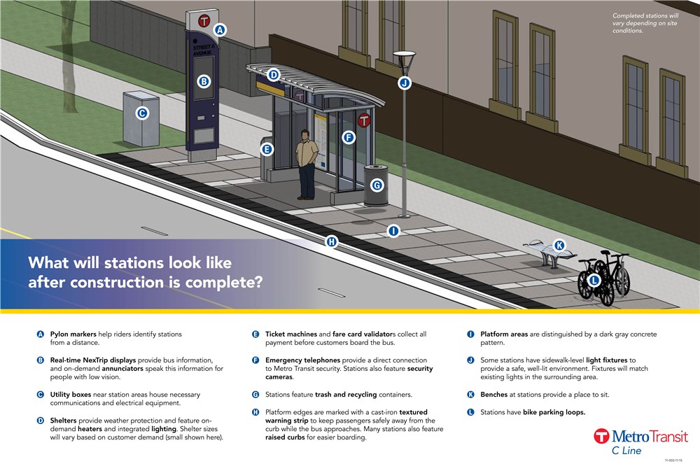
Stations as part of Metro Transit's aBRT (arterial bus rapid transit) service are unique to differentiate them service from local bus stops. Each station has a pylon marker that provides station identification, real time information, and audible departures. Unique shelters feature lighting, heating, emergency telephones and security cameras, and station areas will have seating, bike parking, and trash and recycling. To speed up boarding, platforms are raised 9 in (23 cm) from the pavement to facilitate near-level boarding though any door. Passengers pay before boarding using Go-To card readers or ticket vending machines.[19]
Connections
[edit]
The B Line is a major east-west route in the Metro Transit system, and connects to multiple regional and local transit services. The B Line will connect to the future Metro Green Line extension at its West Lake Street station, and the future Metro E Line will have a connection at Hennepin Avenue. The B Line connects to the Metro Orange, D, and Blue Lines, and shares a station with the Metro A Line at Snelling Avenue and Dayton Avenue. The easternmost stops in Saint Paul are shared with the Metro Gold Line.[20]
| Station[17] | Neighborhood(s)[21][22] | City | Connections[17][18] | |
|---|---|---|---|---|
| Lake & France | West Maka Ska | Minneapolis | Route 17 | |
| West Lake Street | Cedar Isles Dean, West Maka Ska | Route 17, Metro Green Line | ||
| Lake & Dean/West Bde Maka Ska | Cedar Isles Dean | Routes 17, 38 | ||
| Lake & East Bde Maka Ska | Lagoon & East Bde Maka Ska | Cedar Isles Dean, East Bde Maka Ska | Routes 17, 38 | |
| Lake & Hennepin | Lagoon & Hennepin | East Isles, Lowry Hill East, South Uptown, East Bde Maka Ska | Routes 6, 17, 27, 38, 114, Metro E Line | |
| Lake & Lyndale | Lowry Hill East, Whittier, Lyndale, South Uptown | Routes 4, 27, 38, 113 | ||
| Lake & Nicollet | Whittier, Lyndale | Route 18, 27 | ||
| Lake & I-35W | Whittier, Phillips West, Central, Lyndale | Routes 27, 460, 465, 467, 470, 472, 475, 477, 600, 695, Metro Orange Line | ||
| Lake & 4th/5th | Phillips West, Central | Routes 11, 27 | ||
| Lake & Chicago | Phillips West, Midtown Phillips, Powderhorn Park, Central | Route 5, Metro D Line | ||
| Lake & Bloomington | Midtown Phillips, East Phillips, Powderhorn Park | Route 14 | ||
| Lake & Cedar | East Phillips, Corcoran, Powderhorn Park | Routes 22, 27 | ||
| Lake Street/Midtown | East Phillips, Longfellow, Corcoran | Route 27, Metro Blue Line | ||
| Lake & Minnehaha | Longfellow | Routes 7, 27 | ||
| Lake & 31st Ave | Longfellow | |||
| Lake & 36th Ave | Longfellow | Route 9 | ||
| Lake & 44th Ave | Cooper | |||
| Marshall & Otis | Union Park | Saint Paul | ||
| Marshall & Cretin | Union Park | Route 63 | ||
| Marshall & Cleveland | Union Park | Route 87 | ||
| Marshall & Fairview | Union Park | |||
| Snelling & Dayton | Union Park | Metro A Line | ||
| Selby & Hamline | Union Park | Route 72 | ||
| Selby & Lexington | Union Park, Summit-University | Routes 72, 83 | ||
| Selby & Victoria | Summit-University | Route 72 | ||
| Selby & Dale | Summit-University | Routes 65, 72 | ||
| Selby & Western-Arundel | Summit-University | Route 72 | ||
| John Ireland & Marshall | Summit-University | Route 72 | ||
| Smith Ave Ramp | Smith & 5th St | Downtown Saint Paul | Metro Gold Line, many downtown bus routes | |
| 6th St & Washington St | Rice Park | Downtown Saint Paul | Metro Gold Line, many downtown bus routes | |
| 6th St & Minnesota | 5th St & Cedar | Downtown Saint Paul | Metro Green Line, Metro Gold Line, many downtown bus routes | |
| 6th St & Jackson | 5th St & Robert St | Downtown Saint Paul | Metro Gold Line, Metro G Line, many downtown bus routes | |
| Union Depot & Sibley | Union Depot & Wacouta | Downtown Saint Paul | Metro Green Line, Metro Gold Line, many downtown bus routes | |
| Saint Paul Union Depot | Downtown Saint Paul | Metro Green Line, Metro Gold Line, many downtown bus routes | ||
See also
[edit]References
[edit]- ^ "B Line Project - Metro Transit". www.metrotransit.org. Retrieved October 18, 2019.
- ^ Roth, Katie (September 25, 2023). "Arterial BRT Projects Update". Metropolitan Council Transportation Committee. Metro Transit. Retrieved November 2, 2023.
- ^ a b "B Line Project". Metro Transit. Metro Transit. Archived from the original on February 7, 2025. Retrieved March 23, 2025.
- ^ Metro Transit (June 14, 2025). "METRO B Line opening day festivities canceled" (Press release). Metropolitan Council. Retrieved June 14, 2025.
- ^ Diers, John W.; Isaacs, Aaron (2007). Twin Cities by trolley : the streetcar era in Minneapolis and St. Paul. Minneapolis: University of Minnesota Press. ISBN 978-0-8166-4358-5.
- ^ a b c Melo, Frederick (January 2, 2020). "Metro Transit's new B Line will extend to downtown St. Paul, a victory for transit advocates". St. Paul Pioneer Press. Retrieved September 5, 2020.
- ^ Lindeke, Bill (April 16, 2019). "From streetcar to BRT: The return of the Selby-Lake transit corridor?". MinnPost. Retrieved September 5, 2020.
- ^ "ABRT Study - Metro Transit". www.metrotransit.org. Retrieved October 19, 2019.
- ^ Moore, Janet (May 8, 2019). "Ecolab CEO, St. Paul mayor and others tout proposed B Line rapid bus". Star Tribune. Retrieved September 5, 2020.
- ^ a b Thomas, Dylan (October 28, 2019). "Met Council gets behind a faster ride for St. Paul commuters". Minneapolis/St. Paul Business Journal. Retrieved September 5, 2020.
- ^ Moore, Janet (October 22, 2020). "Two Twin Cities rapid bus lines win state funding". Star Tribune. Retrieved October 23, 2020.
- ^ Melo, Frederick (October 26, 2020). "One of St. Paul's busiest bus routes will get a major upgrade". St. Paul Pioneer Press. Retrieved November 10, 2020.
- ^ "The B Line rapid bus may replace Route 21 from Uptown Minneapolis to downtown St. Paul". Twin Cities. April 15, 2019. Retrieved October 19, 2019.
- ^ "B Line Open House Boards" (PDF). www.metrotransit.org. June 6, 2019. Retrieved October 19, 2019.
- ^ Roth, Katie (October 28, 2019). "METRO B Line Update and Preliminary Recommendations".
- ^ "Network Now Framework". Metro Transit. Retrieved June 15, 2025.
- ^ a b c "Metro B Line Schedule" (PDF). Metro Transit. June 14, 2025. Retrieved June 14, 2025.
- ^ a b c d "B Line supporting bus network". Metro Transit. Retrieved June 14, 2025.
- ^ "BRT Station Characteristic". www.metrotransit.org. Retrieved October 19, 2019.
- ^ "B Line Fact Sheet" (PDF). Metro Transit. April 29, 2019. Retrieved October 19, 2019.
- ^ "Minneapolis Neighborhood Map". City of Minneapolis. Retrieved June 14, 2025.
- ^ "Saint Paul District Council and Ward Lookup". stpaul.maps.arcgis.com. City of Saint Paul. Retrieved October 2, 2022.
External links
[edit] Media related to Metro B Line at Wikimedia Commons
- B Line Project website
Currently operating bus rapid transit systems in the United States | |||||||||||||||||||||||||||||||||||||||||||||||||||||||||
|---|---|---|---|---|---|---|---|---|---|---|---|---|---|---|---|---|---|---|---|---|---|---|---|---|---|---|---|---|---|---|---|---|---|---|---|---|---|---|---|---|---|---|---|---|---|---|---|---|---|---|---|---|---|---|---|---|---|
| |||||||||||||||||||||||||||||||||||||||||||||||||||||||||