
Manorhaven, New York
Manorhaven, New York | |
|---|---|
| Incorporated Village of Manorhaven | |
 Manorhaven Village Hall in 2011 | |
 Official Seal of Manorhaven | |
| Nickname(s): Haven; VOM | |
| Motto(s): "Free Enterprise"; "The Pearl of Manhasset Bay" | |
 Location in Nassau County and the state of New York | |
 Manorhaven, New York Location on Long Island  Manorhaven, New York Location within the state of New York | |
| Coordinates: 40°50′31″N 73°42′50″W / 40.84194°N 73.71389°W | |
| Country | |
| State | |
| County | Nassau |
| Town | North Hempstead |
| Incorporated | 1930 |
| Government | |
| • Mayor | John Popeleski |
| • Deputy Mayor | Vincent Costa |
| Area | |
• Total | 0.63 sq mi (1.64 km2) |
| • Land | 0.47 sq mi (1.22 km2) |
| • Water | 0.17 sq mi (0.43 km2) |
| Elevation | 16 ft (5 m) |
| Population (2020) | |
• Total | 6,956 |
| • Density | 14,831.56/sq mi (5,720.55/km2) |
| Demonym(s) | Manorhavenite; Port Washingtonian |
| Time zone | UTC-5 (Eastern (EST)) |
| • Summer (DST) | UTC-4 (EDT) |
| ZIP code | 11050 |
| Area code(s) | 516, 363 |
| FIPS code | 36-45106 |
| GNIS feature ID | 0956378 |
| Website | www |
Manorhaven is a village in Nassau County, on the North Shore of Long Island, in New York, United States. It is considered part of the Greater Port Washington area, which is anchored by Port Washington. The population was 6,956 at the time of the 2020 census.
The Incorporated Village of Manorhaven is located on the Cow Neck Peninsula, within the Town of North Hempstead.
History
[edit]Manorhaven was incorporated as a village in 1930, after news was spread that Port Washington was planning on incorporating itself as a city.[2] The majority of residents in what would ultimately become the Village of Manorhaven wished to retain home rule, leading to a push to incorporate and a referendum on the matter being held that year. This referendum was held that September, with residents voting 34-to-0 in favor of incorporation, in turn officially establishing Manorhaven as an incorporated village; its population, at the time, was 376.[2][3][4] Later that month, residents elected Charles Wesley Copp as the Village's first Mayor.[4]
In 1931, one year after the Manorhaven incorporated, the village proposed annexing the territory which would eventually become the Village of Port Washington North.[5] Manorhaven's annexation bid was unsuccessful due to the residents in what would ultimately become Port Washington North preferring to incorporate as a separate village; Port Washington North ultimately incorporated as its own village one year later, in 1932.[5]
The Town of North Hempstead-owned Manorhaven Beach Park opened within the village circa 1936, revitalizing a major portion of Manorhaven's waterfront along Manhasset Bay.[6][7]
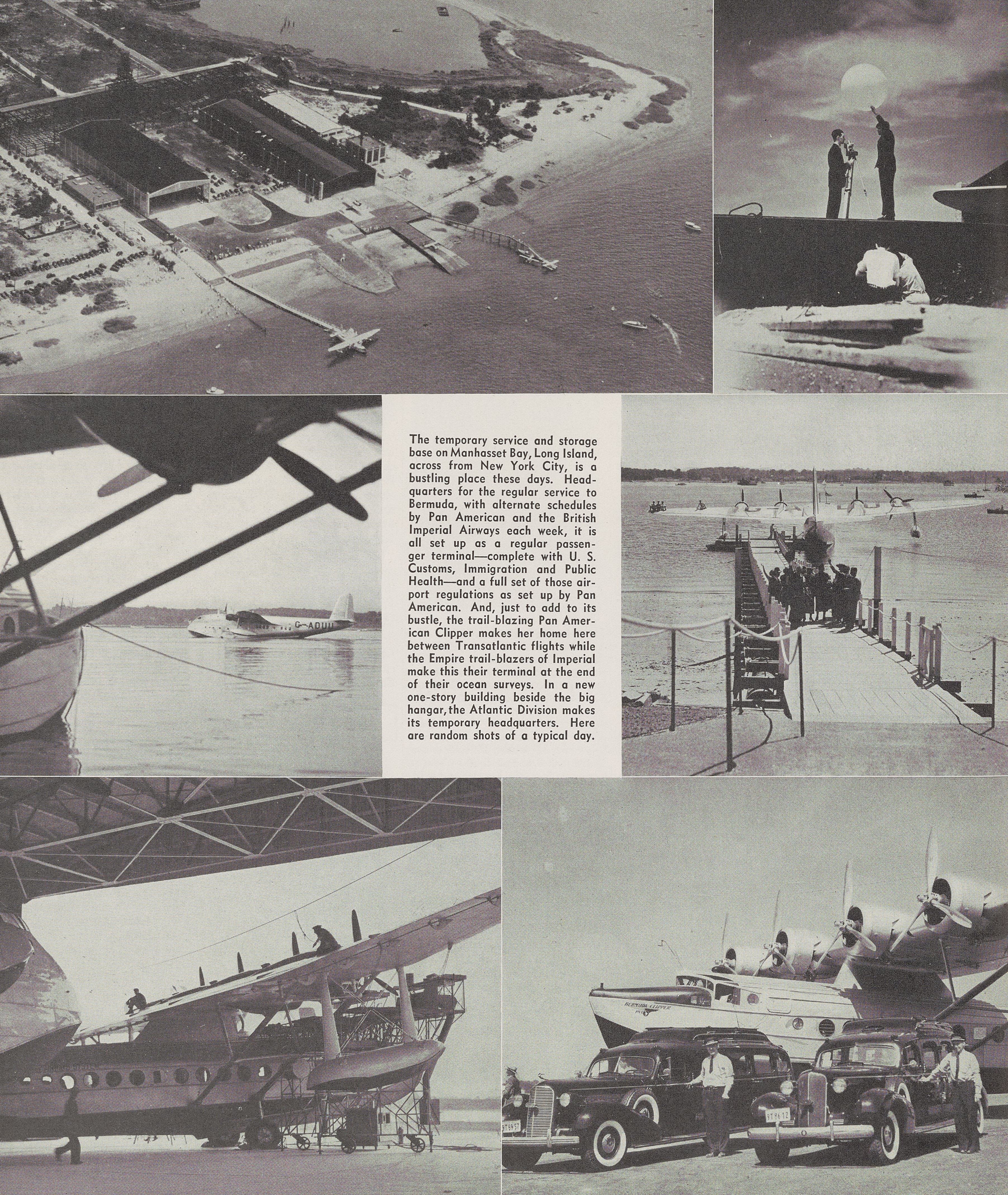
Between 1939 and 1940, Manhasset Bay was used as the New York base of Pan American World Airways' transatlantic Boeing 314 flights, prior to the opening of LaGuardia Airport's Marine Air Terminal, with the airport's hangars and terminal located within Manorhaven, at Toms Point on Manhasset Isle, near the southern edge of the village; the facility was subsequently used by Grumman, following the Marine Air Terminal's opening.[8][9][10][11][12] Although the seaplane hangars at Toms Point were eventually demolished, the seaplane base is still in use, with the airport's current iteration being activated in 1948.[13][14][15]
In 1944, Nassau County announced that it would reconstruct Shore Road through the village, widening it to 70 feet (21 m) and eliminating dangerous curves.[16]
In 1948, Manorhaven residents and officials debated whether to join the Port Washington Police District, and for the Port Washington Police to subsequently take over police operations in the village from the Nassau County Police Department.[17][18] The proposal was rejected by residents, with the majority of village voters opting for the village remain under the Nassau County Police Department's jurisdiction.[17][18]
In 1982, the Village of Manorhaven annexed approximately 20,000 square feet (1,900 m2) from unincorporated Port Washington.[19]
In 1984, Manorhaven residents and officials again debated whether the village should join the Port Washington Police District.[20][18] If approved, the Port Washington Police District would have taken over the police services within the village from the Nassau County Police Department.[20][18] Proponents felt that the Port Washington Police District would be able to better serve the needs of the village, while opponents expressed concerns over potential tax increases.[20] Ultimately, the village, once again, decided to remain under the jurisdiction of the NCPD.[18]
In 2022, Manorhaven Boulevard underwent a major rehabilitation and beautification project, carried out by Nassau County in collaboration with the Village of Manorhaven.[21]
on June 20, 2023, the village's former Deputy Mayor Vincent Costa was defeated by one vote, after being accused of official misconduct.[22][23][24]
Etymology
[edit]The name of the village was selected by locals, who felt that the "Manorhaven" name appropriately reflected the feel and nature of the area.[2]
Geography
[edit]
According to the United States Census Bureau, the village has a total area of 0.6 square miles (1.6 km2), of which 0.5 square miles (1.3 km2) is land and 0.2 square miles (0.52 km2), or 25.40%, is water.[25]
Additionally, Manorhaven is located on the northern half of the Cow Neck Peninsula, and its territory includes Sheets Creek and portions of Manhasset Bay.[26]
Manorhaven is located within the Manhasset Bay Watershed, which, in turn, places it within the larger Long Island Sound/Atlantic Ocean Watershed.[27][28][29][30]
Topography
[edit]Like the rest of Long Island's North Shore, Manorhaven is situated on a terminal moraine, known as the Harbor Hill Moraine.[31][32] This terminal moraine was formed by glaciers during the Wisconsin Glacial Episode, and is named for Harbor Hill in Roslyn; Harbor Hill is the highest geographic point in Nassau County.[31][32]
According to the United States Environmental Protection Agency and the United States Geological Survey, the highest point in Manorhaven is located at the northeastern corner of the village, at approximately 90 feet (27 m), and the lowest point is Manhasset Bay, which is at sea level.[28][33]
Climate
[edit]Manorhaven has a humid subtropical climate (Cfa), bordering on a hot-summer humid continental climate (Dfa). Average monthly temperatures in the village range from 31.8 °F in January to 75.3 °F in July.[34]
| Climate data for Manorhaven, New York, 1991–2020 normals, extremes 1999–present | |||||||||||||
|---|---|---|---|---|---|---|---|---|---|---|---|---|---|
| Month | Jan | Feb | Mar | Apr | May | Jun | Jul | Aug | Sep | Oct | Nov | Dec | Year |
| Record high °F (°C) | 71 (22) |
73 (23) |
87 (31) |
94 (34) |
96 (36) |
101 (38) |
108 (42) |
105 (41) |
97 (36) |
89 (32) |
83 (28) |
76 (24) |
108 (42) |
| Mean daily maximum °F (°C) | 39.8 (4.3) |
41.9 (5.5) |
48.7 (9.3) |
59.7 (15.4) |
69.4 (20.8) |
78.6 (25.9) |
84.0 (28.9) |
82.6 (28.1) |
76.4 (24.7) |
65.2 (18.4) |
54.5 (12.5) |
45.0 (7.2) |
62.2 (16.7) |
| Daily mean °F (°C) | 33.0 (0.6) |
34.5 (1.4) |
41.0 (5.0) |
51.2 (10.7) |
60.8 (16.0) |
70.2 (21.2) |
75.9 (24.4) |
74.8 (23.8) |
68.3 (20.2) |
57.3 (14.1) |
47.1 (8.4) |
38.6 (3.7) |
54.4 (12.5) |
| Mean daily minimum °F (°C) | 26.1 (−3.3) |
27.1 (−2.7) |
33.2 (0.7) |
42.6 (5.9) |
52.2 (11.2) |
61.8 (16.6) |
67.8 (19.9) |
66.9 (19.4) |
60.3 (15.7) |
49.5 (9.7) |
39.8 (4.3) |
32.1 (0.1) |
46.6 (8.1) |
| Record low °F (°C) | −4 (−20) |
−5 (−21) |
5 (−15) |
13 (−11) |
34 (1) |
43 (6) |
50 (10) |
46 (8) |
38 (3) |
27 (−3) |
18 (−8) |
−2 (−19) |
−5 (−21) |
| Average precipitation inches (mm) | 3.86 (98) |
3.06 (78) |
4.30 (109) |
4.02 (102) |
3.75 (95) |
4.31 (109) |
4.06 (103) |
4.33 (110) |
4.22 (107) |
4.20 (107) |
3.42 (87) |
4.31 (109) |
47.84 (1,214) |
| Average snowfall inches (cm) | 1.85 (4.7) |
7.8 (20) |
3.7 (9.4) |
0.3 (0.76) |
0 (0) |
0 (0) |
0 (0) |
0 (0) |
0 (0) |
0 (0) |
0.2 (0.51) |
5.7 (14) |
19.55 (49.37) |
| Average relative humidity (%) | 73 | 75 | 72 | 72 | 75 | 74 | 73 | 71 | 73 | 73 | 71 | 75 | 73 |
| Average dew point °F (°C) | 22.0 (−5.6) |
22.3 (−5.4) |
27.3 (−2.6) |
37.0 (2.8) |
48.2 (9.0) |
58.9 (14.9) |
64.4 (18.0) |
64.2 (17.9) |
58.1 (14.5) |
47.2 (8.4) |
36.5 (2.5) |
27.9 (−2.3) |
42.8 (6.0) |
| Mean monthly sunshine hours | 177 | 153 | 172 | 167 | 202 | 213 | 237 | 241 | 215 | 190 | 210 | 171 | 2,348 |
| Mean daily daylight hours | 9.6 | 10.7 | 12.0 | 13.3 | 14.5 | 15.1 | 14.8 | 13.7 | 12.4 | 11.1 | 9.9 | 9.3 | 12.2 |
| Average ultraviolet index | 2 | 2 | 2 | 4 | 5 | 6 | 6 | 6 | 5 | 3 | 2 | 2 | 4 |
| Source 1: NOAA, PRISM, The Weather Channel (temperatures, average dew points, and average precipitation)[35][36] | |||||||||||||
| Source 2: Weather Spark (all other data)[37] | |||||||||||||
Plant zone
[edit]According to the United States Department of Agriculture, the village is located within hardiness zone 7b.[38]
Demographics
[edit]| Census | Pop. | Note | %± |
|---|---|---|---|
| 1940 | 484 | — | |
| 1950 | 1,819 | 275.8% | |
| 1960 | 3,566 | 96.0% | |
| 1970 | 5,488 | 53.9% | |
| 1980 | 5,384 | −1.9% | |
| 1990 | 5,672 | 5.3% | |
| 2000 | 6,138 | 8.2% | |
| 2010 | 6,556 | 6.8% | |
| 2020 | 6,956 | 6.1% | |
| U.S. Decennial Census[39] | |||
2010 census
[edit]As of the 2010 census, there were 6,556 people residing in the village.[40] The population density was 14,103.7 inhabitants per square mile (5,445.5/km2). The racial makeup of the village was 52.6% White alone, 0.05% Native American, 17.5% Asian, 1.4% African American, 0.1% from other races, 1.3% Two or more races, and 0.1% from other races. Hispanic or Latino of any race were 27.1% of the population.
Census 2000
[edit]As of the census of 2000, there were 6,138 people, 2,401 households, and 1,627 families residing in the village.[40] The population density was 13,055.6 inhabitants per square mile (5,040.8/km2). There were 2,471 housing units at an average density of 5,255.8 per square mile (2,029.3/km2). The racial makeup of the village was 76.60% White, 1.30% African American, 0.26% Native American, 13.38% Asian, 5.16% from other races, and 3.29% from two or more races. Hispanic or Latino of any race were 19.50% of the population.
There were 2,401 households, out of which 31.5% had children under the age of 18 living with them, 52.9% were married couples living together, 10.9% had a female householder with no husband present, and 32.2% were non-families. 25.7% of all households were made up of individuals, and 7.5% had someone living alone who was 65 years of age or older. The average household size was 2.56 and the average family size was 3.07.
In the village, the population was spread out, with 22.3% under the age of 18, 6.4% from 18 to 24, 36.7% from 25 to 44, 23.8% from 45 to 64, and 10.9% who were 65 years of age or older. The median age was 37 years. For every 100 females, there were 98.0 males. For every 100 females age 18 and over, there were 95.9 males.
The median income for a household in the village was $61,474, and the median income for a family was $66,744. Males had a median income of $45,733 versus $43,182 for females. The per capita income for the village was $36,254. About 7.6% of families and 8.9% of the population were below the poverty line, including 14.1% of those under age 18 and 5.8% of those age 65 or over.
Government
[edit]Village government
[edit]As of July 2025, the Mayor of Manorhaven is John Popeleski, the Deputy Mayor is Harry Farina, and the Village Trustees are Harry Farina, Monica Ildefonso, Khristine Shahipour and Jeffrey Stone.[41][42][43]
Representation in higher government
[edit]Town representation
[edit]Manorhaven is located in the Town of North Hempstead's 6th council district, which as of July 2025 is represented in the North Hempstead Town Council by Mariann Dalimonte (D–Port Washington).[44]
Nassau County representation
[edit]Manorhaven is located in Nassau County's 11th Legislative district, which as of July 2025 is represented in the Nassau County Legislature by Delia DiRiggi-Whitton (D–Glen Cove).[45][46]
New York State representation
[edit]New York State Assembly
[edit]Manorhaven is located within the New York State Assembly's 16th State Assembly district, which as of July 2025 is represented by Daniel J. Norber (R–Great Neck).[45][47][48]
New York State Senate
[edit]Manorhaven is located in the New York State Senate's 7th State Senate district, which as of July 2025 is represented by Jack M. Martins (R–Old Westbury).[45][49]
Federal representation
[edit]United States Congress
[edit]Manorhaven is located in New York's 3rd congressional district, which as of July 2025 is represented by Thomas R. Suozzi (D–Glen Cove).[45][50]
United States Senate
[edit]Like the rest of New York, Manorhaven is represented in the United States Senate by Charles E. Schumer (D) and Kirsten Gillibrand (D).[51]
Politics
[edit]In the 2024 U.S. presidential election, the majority of Manorhaven voters voted for Kamala D. Harris (D).[52][53][54]
Parks and recreation
[edit]- Manorhaven Beach Park – a major park owned and operated by the Town of North Hempstead, located along Manhasset Bay within the village.[7][45]

The beach at Manorhaven Beach Park in 2011 - Morgan's Dock Park – a smaller, village-owned park along Manhasset Bay, just north of Manorhaven Beach Park.[45]
- Manorhaven Preserve – a village-owned nature preserve along Sheets Creek.[45]

Education
[edit]School district
[edit]The Village of Manorhaven is located entirely within the boundaries of the Port Washington Union Free School District.[45][55] As such, all children who reside within Manorhaven and attend public schools go to Port Washington's schools.[45][55]
Library district
[edit]Manorhaven is located within the boundaries of the Port Washington Library District.[45]
Infrastructure
[edit]Transportation
[edit]Road
[edit]
Major roads in Manorhaven include Manhasset Avenue, Manorhaven Boulevard (CR D44), Orchard Beach Boulevard, Sands Point Road, and Shore Road (CR E25).[29][21]
Road layout
[edit]The majority of the street layout in Manorhaven resembles the traditional street grid.[29] Manhasset Avenue in the southern part of the village is a notable exception, as it traverses the grid diagonally.[29] Many streets use street-naming conventions of local Native American tribes and places (i.e.: Mohegan Avenue) and of woods (i.e.: Cottonwood Road).[29]
Bus
[edit]
As of July 2024, Manorhaven is served by one Nassau Inter-County Express (NICE) bus route: the n23, which runs between it and the Mineola Intermodal Center in the Village of Mineola.[56]
Utilities
[edit]Natural gas
[edit]National Grid USA provides natural gas to homes and businesses that are hooked up to natural gas lines in Manorhaven.[57][58][59]
Power
[edit]PSEG Long Island, provides power to all homes and businesses within Manorhaven.[57][58][60]
Sewage
[edit]Manorhaven maintains a village sanitary sewer system, which, through a contract, has its sewage transferred to – and treated by – the Port Washington Water Pollution Control District.[61][62]
Water
[edit]Manorhaven is located within the boundaries of the Port Washington Water District, which provides the entirety of the village with water.[45]
Healthcare and emergency services
[edit]Healthcare
[edit]No hospitals are located within Manorhaven.[45] The nearest hospital is St. Francis Hospital, located in nearby Flower Hill.[45][63]
Fire
[edit]The Village of Manorhaven, in its entirety, is located within the boundaries of (and is thus served by) the Port Washington Fire District.[45][64]
Police
[edit]
The Village of Manorhaven is served by the Sixth Precinct of the Nassau County Police Department.[45][65]
Additionally, the Sixth Precinct operates a police booth in the village, along Manorhaven Boulevard.[65]
Notable person
[edit]- Gina L. Sillitti – Politician.[66] Sillitti served as the area's representative in the New York State Assembly between 2021 and 2025.[66][67]
See also
[edit]References
[edit]- ^ "ArcGIS REST Services Directory". United States Census Bureau. Retrieved September 20, 2022.
- ^ a b c Winsche, Richard (October 1, 1999). The History of Nassau County Community Place-Names. Interlaken, New York: Empire State Books. ISBN 978-1557871541.
- ^ "Manhasset Isle, Beach Haven and Orchard Beach Carry Incorporation By Vote of 34-0". The Port Washington News. September 12, 1930. Retrieved July 24, 2025.
- ^ a b "Chas. Wesley Copp Is Elected Mayor of Manorhaven". The Port Washington News. October 3, 1931. Retrieved July 24, 2025.
- ^ a b Winsche, Richard (October 1, 1999). The History of Nassau County Community Place-Names. Interlaken, New York: Empire State Books. ISBN 978-1557871541.
- ^ "Health Officer Explains Ban On Bathing at Dock". The Port Washington News. July 31, 1936. p. 1. Retrieved July 26, 2025.
- ^ a b "Chas. Snedeker, 74, Former No. Hemp. Supervisor, Dead". Newsday. February 15, 1946. p. 5 – via ProQuest.
- ^ Stoff, Joshua (2008). LaGuardia Airport. Images of Aviation. Arcadia Publishing. pp. 31 & 32. ISBN 978-0-7385-5799-1. LCCN 2008924409.
- ^ "William John Eck: First Pan American Airlines Transatlantic Flight Scrapbook | Collection: NASM.XXXX.0309". sova.si.edu. Retrieved November 13, 2023.
- ^ Anderson, David (March 31, 1940). "Along the Far-flung Airways; City Field Ocean Base La Guardia Seaplane Unit Speeds Clipper Today --Looks to Future". The New York Times. ISSN 0362-4331. Archived from the original on August 3, 2022. Retrieved August 3, 2022.
- ^ Lauria-Blum, Julia (October 11, 2022). "New York Seaplanes & Skyports". Metropolitan Airport News. Retrieved November 13, 2023.
- ^ Harris-Para, Barbara (October 7, 2015). "100 YEARS OF SUSTAINED POWER FLIGHT HISTORY" (PDF). Federal Aviation Administration. p. 7. Archived (PDF) from the original on February 9, 2017. Retrieved December 6, 2020.
1937: First regular commercial transatlantic airline service in America – Pan American Martin & Boeing Flying boats departed & arrived at Port Washington.
- ^ Hanc, John (October 2, 2020). "Soaring success: In 1939, Port Washington's place in aviation history took off". Newsday. Retrieved November 14, 2023.
- ^ Library, Vanessa Nastro and the Port Washington Public (October 5, 2020). Along Manhasset Bay. Arcadia Publishing. ISBN 978-1-4671-0502-6.
- ^ "Pan Am Seaplane Base, Manhasset Bay". University of Miami. Retrieved November 13, 2023.
- ^ "Map On File Indicates Widening Of Shore Rd. To A Width Of 70 Feet". The Port Washington News. March 10, 1944. p. 1. Retrieved July 27, 2025.
- ^ a b "Village May 'Secede' From County Cops". Newsday. July 28, 1943. pp. 3, 54.
- ^ a b c d e English, Merle (September 24, 1984). "Village to Keep County Police Services". Newsday.
- ^ "Manorhaven Annexes Land". Newsday. December 22, 1982. pp. 21A1.
- ^ a b c English, Merle (August 1, 1984). "Debate on Police Divides Village". Newsday. p. 26.
- ^ a b "Residents go out on a limb for trees, delay $6M Manorhaven streetscape project". Newsday. Retrieved August 6, 2021.
- ^ Oakes, Cameryn (June 20, 2023). "State asked to probe Manorhaven Trustee Costa in pension document complaint – Featured". The Island 360. Retrieved August 2, 2024.
- ^ Oakes, Cameryn (June 30, 2023). "Manorhaven recanvass determines Shahipour, Stone elected trustees – Featured". The Island 360. Retrieved August 17, 2023.
- ^ Oakes, Cameryn (May 31, 2023). "Manorhaven fires clerk in surprise resolution – Featured". The Island 360. Retrieved August 17, 2023.
- ^ "US Gazetteer files: 2010, 2000, and 1990". United States Census Bureau. February 12, 2011. Retrieved April 23, 2011.
- ^ Rather, John (November 17, 1996). "Solid Comfort, in Distinct Enclaves (Published 1996)". The New York Times. ISSN 0362-4331. Retrieved January 11, 2021.
- ^ New York Rapid Watershed Assessment Profile – Northern Long Island Watershed. Syracuse, New York: United States Department of Agriculture Natural Resources Conservation Service. 2011.
- ^ a b "EPA – Waters GeoViewer". United States Environmental Protection Agency. Retrieved July 28, 2021.
- ^ a b c d e "Manorhaven Village – Powered by GovPilot". map.govpilot.com. Retrieved August 6, 2021.
- ^ "Atlantic Ocean/Long Island Sound Watershed – NYS Dept. of Environmental Conservation". www.dec.ny.gov. Retrieved July 27, 2021.
- ^ a b "Garvies Point Museum and Preserve – Geology of Long Island". Garvies Point Museum. Retrieved November 7, 2020.
- ^ a b "Geology – Friends of the Bay". Friends of the Bay. Retrieved November 7, 2020.[permanent dead link]
- ^ "The National Map – Advanced Viewer". United States Geological Survey. Retrieved July 30, 2021.
- ^ "PRISM Climate Group at Oregon State University". prism.oregonstate.edu.
- ^ "xmACIS2 (Applied Climate Information System) – Port Washington 1991–2020 Raw Averages and 1938–2011 Extremes". NOAA. Retrieved January 1, 2025.
- ^ "Monthly Averages for Manorhaven, NY". The Weather Channel. Retrieved January 1, 2025.
- ^ "Climate and monthly weather forecast Baxter Estates, NY". Weather Spark. Retrieved January 1, 2025.
- ^ "USDA Plant Hardiness Zone Map". planthardiness.ars.usda.gov. Retrieved September 20, 2021.
- ^ "Census of Population and Housing". Census.gov. Retrieved June 4, 2015.
- ^ a b "U.S. Census website". United States Census Bureau. Retrieved January 31, 2008.
- ^ "BOARDS & STAFF". Village of Manorhaven New York. Retrieved August 6, 2021.
- ^ Oakes, Cameryn (July 10, 2023). "Manorhaven appoints Farina as deputy mayor, swears in elected officials – Port Washington Times". The Island 360. Retrieved August 17, 2023.
- ^ Oakes, Cameryn (June 21, 2023). "Manorhaven elects Jeffrey Stone to Board of Trustees – Featured". The Island 360. Retrieved August 17, 2023.
- ^ "Town of North Hempstead – Councilwoman Mariann Dalimonte". northhempsteadny.gov. Retrieved December 18, 2020.
- ^ a b c d e f g h i j k l m n o "Long Island Zoning Atlas". Long Island Index Maps. Long Island Index.
- ^ "District 11 – Delia DeRiggi-Whitton | Nassau County, NY – Official Website". www.nassaucountyny.gov. Retrieved December 18, 2020.
- ^ "Daniel J. Norber - Assembly District 16 |Assembly Member Directory | New York State Assembly". nyassembly.gov. Retrieved January 1, 2025.
- ^ Walker, Corey (November 11, 2024). "Ex-IDF Soldier Becomes First Republican in 50 Years to Win New York State Assembly Seat in Long Island District". The Algemeiner. Retrieved November 15, 2024.
- ^ "NY Senate District 7". NY State Senate. Retrieved July 22, 2021.
- ^ Fandos, Nicholas (February 29, 2024). "Tom Suozzi Returns to Congress With 2 Words for House: 'Wake Up'". The New York Times. ISSN 0362-4331. Retrieved March 1, 2024.
- ^ "U.S. Senate: Contacting U.S. Senators". www.senate.gov. Retrieved July 22, 2021.
- ^ LaRocco, Paul (November 12, 2024). "Map: How Long Island voted for president in Harris-Trump race". Newsday. Retrieved November 12, 2024.
- ^ Park, Alice; Smart, Charlie; Taylor, Rumsey; Watkins, Miles (February 2, 2021). "An Extremely Detailed Map of the 2020 Election". The New York Times. ISSN 0362-4331. Retrieved July 20, 2024.
- ^ Welch, Will (November 8, 2017). "How Long Island Voted". Newsday. Retrieved June 23, 2021.
- ^ a b "Composite School District Boundaries Shapefiles". NCES. Retrieved October 23, 2020.
- ^ "Nassau Inter-County Express – Maps and Schedules". nicebus.com. Retrieved August 10, 2020.
- ^ a b "Emergency Information". Village of Manorhaven New York. Retrieved August 6, 2021.
- ^ a b "Long Island Utility Information – LIPA, Nat Grid, & Local Water Authorities". LongIsland.com. Retrieved October 24, 2020.
- ^ "Natural Gas & Electricity | National Grid". www.nationalgridus.com. Retrieved July 21, 2021.
- ^ "Home Page – PSEG Long Island". www.psegliny.com. Retrieved July 21, 2021.
- ^ "Repairs To Aging Port Washington Sewers To Begin Next Week". Port Washington, NY Patch. October 22, 2019. Retrieved August 5, 2021.
- ^ "Port Washington Water Pollution Control District". www.pwwpcd.us. Retrieved August 5, 2021.
- ^ "About Us". St. Francis Heart Center. Retrieved September 6, 2020.
- ^ "Department | Port Washington Fire Department". Retrieved October 24, 2020.
- ^ a b "County Map | Nassau County Police, NY". pdcn.org. Retrieved October 24, 2020.
- ^ a b Hampton, Daniel (November 18, 2020). "Sillitti Declares Victory Over Srivastava In Assembly District 16". Port Washington, NY Patch. Retrieved December 18, 2020.
- ^ "Gina L. Sillitti – Assembly District 16 |Assembly Member Directory | New York State Assembly". nyassembly.gov. Retrieved July 22, 2021.
External links
[edit]Places adjacent to Manorhaven, New York | ||||||||||||||||
|---|---|---|---|---|---|---|---|---|---|---|---|---|---|---|---|---|
| ||||||||||||||||
| International | |
|---|---|
| National | |