Khuzdar Tehsil
Khuzdar
Brahui: تحصیل خضدار | |
|---|---|
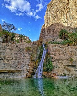
 Charoo Waterfall | |
| Coordinates: 27°50′N 66°38′E / 27.833°N 66.633°E | |
| Country | |
| Province | Balochistan |
| District | Khuzdar District |
| Tehsil | Khuzdar |
| Area | |
• Tehsil of Khuzdar District | 6,112 km2 (2,360 sq mi) |
| Population (2023)[1] | |
• Tehsil of Khuzdar District | 359,358 |
| • Density | 58.80/km2 (152.3/sq mi) |
| • Urban | 218,112 |
| • Rural | 141,246 |
| Literacy | |
| • Literacy rate | 38.59%[2] |
| Time zone | UTC+5 (PST) |
| Main languages | 342,974 Brahui, 6,044 Pashto, 5,652 Balochi[3] |
Khuzdar (Balochi: قصدار; Urdu: خضدار, pronounced ['xʊzd̪ɑːɾ]) is an administrative subdivision (tehsil) of Khuzdar District in Balochistan, Pakistan.[1] It is one of ten administrative units, comprising tehsils and sub-tehsils, in the district, alongside Aranji, Gresha, Karakh, Moola, Nal, Ornach, Saroona, Wadh, and Zehri. The tehsil covers an area of 6,112 square kilometres, characterised predominantly by mountainous terrain. It is centred around the city of Khuzdar, which serves as the district headquarters, and extends southeastward toward the border with Sindh.
Population
[edit]| Year | Pop. | ±% p.a. |
|---|---|---|
| 1951 | ... | — |
| 1961 | 52,062 | — |
| 1972 | 106,981 | +6.77% |
| 1981 | 84,115 | −2.64% |
| 1998 | 161,845 | +3.92% |
| 2017 | 299,464 | +3.29% |
| 2023 | 359,358 | +3.09% |
| Pakistan Bureau of Statistics:[4] | ||
According to the 2023 national census, Khuzdar tehsil has a population of 359,358. Of this approximately 60%, or 218,112 individuals, reside in urban areas, primarily in Khuzdar city, while 141,246 live in rural parts of the tehsil.[1] This makes it the most urbanised tehsil in the district.
The overall literacy rate stands at 43.85%, with approximately half of the male population (50.40%) being literate, while the female literacy rate is significantly lower at 36.48%.[2]
Access to safe drinking water is a major issue in the tehsil. Community involvement, especially by women, who are the primary collectors of water, is crucial, particularly in addressing sanitation challenges.[5]
References
[edit]- ^ a b c "Table 1: Area, Population by Sex, Sex Ratio, Population Density, Urban Population, Household Size and Annual Growth Rate, Balochistan" (PDF). pbs.gov.pk. Pakistan Bureau of Statistics, Census. 2023. Retrieved 19 May 2025.
- ^ a b "Table 12 - Population (10 years and above) by Literacy Rate, Enrolment and Out of School Population by Sex and Rural/Urban, Census 2023" (PDF). pbs.gov.pk. Pakistan Bureau of Statistics. Retrieved 19 May 2025.
- ^ "Table 11: Population by Mother Tongue, Gender, and Rural/Urban Residence (Census 2023)" (PDF). pbs.gov.pk. Pakistan Bureau of Statistics. Retrieved 22 May 2025.
- ^ "Table 4: Area and Population of Administrative Units by Rural/Urban: 1951–1998 Censuses" (PDF). Pakistan Bureau of Statistics. Retrieved 3 June 2025.
- ^ Sarfraz, Hamid (2004). Khuzdar, A District Profile. Quetta: Planning & Development Department, Government of Balochistan and Bureau of Statistics, Planning Studies Section. p. 40. Retrieved 20 May 2025.


