
Khalifeh Hesar
Khalifeh Hesar
Persian: خليفه حصار | |
|---|---|
Village | |
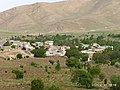
 The village of Khalifeh Hesar | |
 Khalifeh Hesar | |
| Coordinates: 36°01′05″N 49°12′35″E / 36.01806°N 49.20972°E[1] | |
| Country | Iran |
| Province | Zanjan |
| County | Abhar |
| District | Central |
| Rural District | Darsajin |
| Established | Before Islam[a] |
| Population (2016)[2] | |
• Total | 77 |
| Time zone | UTC+3:30 (IRST) |
Khalifeh Hesar (Persian: خليفه حصار)[b] is a village in Darsajin Rural District[4] of the Central District in Abhar County, Zanjan province, Iran.
Demographics
[edit]Population
[edit]At the time of the 2006 National Census, the village's population was 192 in 51 households.[5] The following census in 2011 counted 130 people in 46 households.[6] The 2016 census measured the population of the village as 77 people in 37 households.[2]
Antiquities
[edit]The ancient cemetery of this village called White Hill, which belongs to the Seljuk era, has been registered in the list of national monuments of Iran.[7]
Weather
[edit]| Khalifeh Hesar | ||||||||||||||||||||||||||||||||||||||||||||||||||||||||||||
|---|---|---|---|---|---|---|---|---|---|---|---|---|---|---|---|---|---|---|---|---|---|---|---|---|---|---|---|---|---|---|---|---|---|---|---|---|---|---|---|---|---|---|---|---|---|---|---|---|---|---|---|---|---|---|---|---|---|---|---|---|
| Climate chart (explanation) | ||||||||||||||||||||||||||||||||||||||||||||||||||||||||||||
| ||||||||||||||||||||||||||||||||||||||||||||||||||||||||||||
| ||||||||||||||||||||||||||||||||||||||||||||||||||||||||||||
Gallery
[edit]-
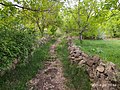 Khalifeh Hesar Alley
 -
 On top of the surrounding mountains
 -
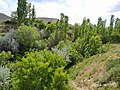 Natural landscape of trees


See also
[edit]Notes
[edit]- ^ According to the ancient shrine of this village, from which several ancient artifacts have been discovered[citation needed]
- ^ Also romanized as Khalīfeh Ḩeşār; also known as Khalfasar, Khalf-e Sār, Khalīfeh Ḩeşār va Mīlān (خليفه حصار و ميلان), and Khalīfeh Ḩeşār-e Mīlān[3]
References
[edit]- ^ OpenStreetMap contributors (28 April 2025). "Khalifeh Hesar, Abhar County" (Map). OpenStreetMap (in Persian). Retrieved 28 April 2025.
- ^ a b Census of the Islamic Republic of Iran, 1395 (2016): Zanjan Province. amar.org.ir (Report) (in Persian). The Statistical Center of Iran. Archived from the original (Excel) on 27 April 2022. Retrieved 19 December 2022.
- ^ Khalifeh Hesar can be found at GEOnet Names Server, at this link, by opening the Advanced Search box, entering "-3070437" in the "Unique Feature Id" form, and clicking on "Search Database".
- ^ Mousavi, Mirhossein (1 January 1391) [Approved 2 February 1366]. Creation and formation of nine rural districts including villages, farms and places located in Abhar County under Zanjan province. rc.majlis.ir (Report) (in Persian). Ministry of the Interior, Board of Ministers. Notification 94117/T289. Archived from the original on 19 March 2012. Retrieved 17 December 2023 – via Islamic Parliament Research Center.
- ^ Census of the Islamic Republic of Iran, 1385 (2006): Zanjan Province. amar.org.ir (Report) (in Persian). The Statistical Center of Iran. Archived from the original (Excel) on 20 September 2011. Retrieved 25 September 2022.
- ^ Census of the Islamic Republic of Iran, 1390 (2011): Zanjan Province. irandataportal.syr.edu (Report) (in Persian). The Statistical Center of Iran. Archived from the original (Excel) on 21 January 2023. Retrieved 19 December 2022 – via Iran Data Portal, Syracuse University.
- ^ "دانشنامهٔ تاریخ معماری و شهرسازی ایرانشهر". وزارت راه و شهرسازی. Archived from the original on 6 October 2019. Retrieved 10 October 2019.
Zanjan province, Iran | ||||||||||||||||
|---|---|---|---|---|---|---|---|---|---|---|---|---|---|---|---|---|
Capital: Zanjan | ||||||||||||||||
| Counties and cities |
|  | ||||||||||||||
| Sights |
| |||||||||||||||
| populated places | ||||||||||||||||
This Abhar County location article is a stub. You can help Wikipedia by expanding it. |