
Hrebinka
Hrebinka
Гребінка | |
|---|---|
 Collage of Hrebinka | |
 Coat of arms | |
 Hrebinka  Hrebinka | |
| Coordinates: 50°7′N 32°25′E / 50.117°N 32.417°E | |
| Country | |
| Oblast | Poltava Oblast |
| Raion | Lubny Raion |
| Hromada | Hrebinka urban hromada |
| Founded | 1895 |
| Population (2022) | |
• Total | 10,541 |
| Area code | +380 5359 |
 | |
Hrebinka (Ukrainian: Гребінка, pronounced [ɦreˈbinkɐ]) is a city in Lubny Raion, Poltava Oblast, Ukraine. It hosts the administration of Hrebinka urban hromada, one of the hromadas of Ukraine.[1] The city is located in the Dnieper lowland, in the forest steppe nature zone. Hrebinka is a railway junction. Population: 10,541 (2022 estimate).[2]
History
[edit]First, a new railway station was built near the village of Horodyshche, which was named Hrebinka in honor of the Ukrainian writer Yevhen Hrebinka, who was born nearby, in the village of Maryanivka.[3]
Until 18 July 2020, Hrebinka was the administrative center of Hrebinka Raion. The raion was abolished in July 2020 as part of the administrative reform of Ukraine, which reduced the number of raions of Poltava Oblast to four. The area of Hrebinka Raion was merged into Lubny Raion. [4][5]
Geography
[edit]The Hrebinka is the center of the Hrebinka urban hromada is the northwest of the Lubny Raion. The distance from Hrebinka to the regional center is 190 kilometers, and to Kyiv - 156 km.[6] The Hrebinka is located on the left bank of the Dnieper River. The city is located in the Dnieper lowland, in the forest steppe nature zone. There is a pine forest near the city. [7][8]
The climate of the Hrebinka is temperate continental. The average temperature in January is −3.7 °C, in July it is +21.4 °C, the amount of precipitation is 480–580 mm/year, which falls mainly in the summer as rain.[7] [6]
Minerals of the Hrebinka territory: clay, sand.[8]
The Kyiv-Kharkiv national highway (M-03) passes near Hrebinka. Interregional highways and a railway running in the Kyiv-Kharkiv direction pass through the city. Hrebinka is a railway junction on the border of three railways: Southern, Southwestern, and Odessa.[9][10]
Gallery
[edit]-
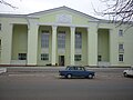 Palace of Culture
 -
 A Sunday market in Hrebinka
 -
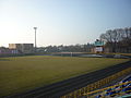 City stadium
 -
 Hrebinka train depot


References
[edit]- ^ "Гребенковская громада" (in Russian). Портал об'єднаних громад України. Retrieved 2023-04-05.
- ^ Чисельність наявного населення України на 1 січня 2022 [Number of Present Population of Ukraine, as of January 1, 2022] (PDF) (in Ukrainian and English). Kyiv: State Statistics Service of Ukraine. Archived (PDF) from the original on 4 July 2022.
- ^ "Гребінка, про яку ви не знали: сучасне місто, що виросло з невеликої станції - ipoltavets.com". 2022-10-21. Retrieved 2023-04-05.
- ^ "Про утворення та ліквідацію районів. Постанова Верховної Ради України № 807-ІХ". Голос України (in Ukrainian). 2020-07-18. Retrieved 2020-10-03.
- ^ "Нові райони: карти + склад" (in Ukrainian). Міністерство розвитку громад та територій України. Retrieved 2023-04-05.
- ^ a b Профіль Гребінківської міської територіальної громади Додаток до Стратегії розвитку Гребінкіської громади. 2024. Сайт Гребінківська міська рада Retrieved 2025-07-06
- ^ a b Булава Л. М. Природа та населення Полтавської області. Навчальний посібник. – Полтава: Полтавський обласний інститут післядипломної освіти педагогічних працівників ім. М.В. Остроградського, 2017. – 42 с. Retrieved 2025-07-05
- ^ a b Полтавська область. Географічний атлас / М-во освіти і науки України, Полтав. держ. пед. ун-т ім. В. Г. Короленка; [відп. ред. Т. В. Погурельська]. – Київ: Мапа, 2004. – 19, [1] c. : іл., карти. – (Моя мала Батьківщина). Retrieved 2025-07-06
- ^ "Гребінки (map)". maps.visicom.ua (in Ukrainian). Retrieved 2025-07-06.
- ^ Постанова Кабінету Міністрів України від 30 січня 2019 року № 55 «Про затвердження переліку автомобільних доріг загального користування державного значення» Retrieved 2025-07-06