
Haskins, Iowa
Haskins, Iowa | |
|---|---|
 Crawford Pond Park, 0.7 miles northwest of Haskins | |
 Haskins, Iowa | |
| Coordinates: 41°19′41″N 91°32′13″W / 41.32806°N 91.53694°W | |
| Country | United States |
| State | Iowa |
| County | Washington |
| Elevation | 758 ft (231 m) |
| Time zone | UTC-6 (Central (CST)) |
| • Summer (DST) | UTC-5 (CDT) |
| Area code | 319 |
| GNIS feature ID | 457309[1] |
Haskins is an unincorporated community in Washington County, Iowa, United States.[1][2]
Notes
[edit]Municipalities and communities of Washington County, Iowa, United States | ||
|---|---|---|
| Cities | 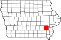 | |
| Townships | ||
| Unincorporated communities | ||
| Footnotes | ‡This populated place also has portions in an adjacent county or counties | |
This article about the geography of Washington County, Iowa is a stub. You can help Wikipedia by expanding it. |