
Griggs, Oklahoma
Griggs, Oklahoma | |
|---|---|
 Griggs | |
| Coordinates: 36°36′10″N 102°07′21″W / 36.60278°N 102.12250°W | |
| Country | United States |
| State | Oklahoma |
| County | Cimarron |
| Elevation | 3,822 ft (1,165 m) |
| Time zone | UTC-6 (Central (CST)) |
| • Summer (DST) | UTC-5 (CDT) |
| Area code | 580 |
| GNIS feature ID | 1100466[1] |
Griggs is an unincorporated community in Cimarron County, Oklahoma, United States, located in the Oklahoma Panhandle.
Griggs is east of Oklahoma State Highway 171 on E0280 Rd, then south on N0525Rd.[2] It is approximately 22 driving miles north of Stratford, Texas[3] and about 28 driving miles east-southeast of Boise City,[4] the county seat.[5] Griggs appears on a 1911 Rand McNally map of the county.[6]
References
[edit]- ^ a b U.S. Geological Survey Geographic Names Information System: Griggs, Oklahoma
- ^ "Griggs, Oklahoma". Google Maps. Retrieved September 10, 2020.
- ^ "Stratford, Texas to Griggs, Oklahoma". Google Maps. Retrieved September 10, 2020.
- ^ "Boise City, Oklahoma to Griggs, Oklahoma". Google Maps. Retrieved September 10, 2020.
- ^ "Cimarron County Genealogy Resources". TravelOK.com. Retrieved September 10, 2020.
- ^ "Cimarron County, Oklahoma 1911 Map". Rand McNally (accessed on Mygenealogyhound.com website). Retrieved March 5, 2025.
Municipalities and communities of Cimarron County, Oklahoma, United States | ||
|---|---|---|
| City | 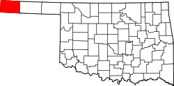 | |
| Town | ||
| CDPs | ||
| Other unincorporated communities | ||
This Oklahoma state location article is a stub. You can help Wikipedia by expanding it. |