Draft:Preah Vihear province
 | Draft article not currently submitted for review.
This is a draft Articles for creation (AfC) submission. It is not currently pending review. While there are no deadlines, abandoned drafts may be deleted after six months. To edit the draft click on the "Edit" tab at the top of the window. To be accepted, a draft should:
It is strongly discouraged to write about yourself, your business or employer. If you do so, you must declare it. Where to get help
How to improve a draft
You can also browse Wikipedia:Featured articles and Wikipedia:Good articles to find examples of Wikipedia's best writing on topics similar to your proposed article. Improving your odds of a speedy review To improve your odds of a faster review, tag your draft with relevant WikiProject tags using the button below. This will let reviewers know a new draft has been submitted in their area of interest. For instance, if you wrote about a female astronomer, you would want to add the Biography, Astronomy, and Women scientists tags. Editor resources
Last edited by SuperBossaNova (talk | contribs) 4 days ago. (Update) |
Preah Vihear
ព្រះវិហារ | |
|---|---|
| Preah Vihear Province ខេត្តព្រះវិហារ | |
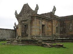
 Preah Vihear Temple, from which the province received its name | |
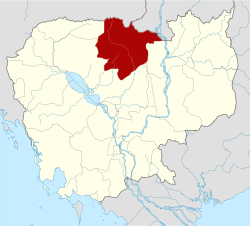
 Map of Cambodia highlighting Preah Vihear | |
| Coordinates: 13°47′N 104°58′E / 13.783°N 104.967°E | |
| Country | |
| ICJ ruling | 15 June 1962 |
| Provincial status | 22 July 1964[1] |
| Named after | Preah Vihear Temple |
| Capital | Preah Vihear |
| Government | |
| • Governor | Kim Rithy (CPP) |
| • National Assembly | 1 / 125
|
| Area | |
• Total | 13,788 km2 (5,324 sq mi) |
| • Rank | 3rd |
| Population (2024)[2] | |
• Total | |
| • Rank | 18th |
| • Density | 18/km2 (50/sq mi) |
| • Rank | 22nd |
| Time zone | UTC+7 (ICT) |
| Dialing code | +855 |
| ISO 3166 code | KH-13 |
| Website | www |
Preah Vihear (Khmer: ព្រះវិហារ, UNGEGN: Preăh Vĭhar, ALA-LC: Braḥ Vihār [preah ʋihiə]; lit. 'sacred sanctuary') is a province (khaet) of Cambodia. It borders the provinces of Oddar Meanchey and Siem Reap to the west, Kampong Thom to the south and Stung Treng to the east. Its northern boundary forms part of Cambodia's international border with Thailand and Laos. Its capital is Preah Vihear.
Etymology
[edit]The name Preah Vihear means "sacred temple" in Khmer, referring to the famous Preah Vihear Temple located on the Dangrek Mountains near the Thai border.
History
[edit]Preah Vihear was established by Royal Decree No. 194-B-R on July 22, 1964, following Cambodia’s victory over Thailand through the verdict issued on June 15, 1962, by the International Court of Justice in The Hague, Netherlands.[1]
According to administrative documents, at that time Preah Vihear Province comprised only four districts: Rovieng, Chaeb, and Choam Khsant, which were carved out of Kampong Thom Province, and Angkor Thom District, the latter having been separated from Siem Reap Province with three included communes: Anlong Veng, Thkav, and Koh Ker. Kampong Thom Province retained Kampong Svay District, which included Stueng, Prum Tep, Phnom Tbeng, and Thma communes, separated from Sandan District in Kampong Thom and parts of Stung Treng Province.[1]
Tbeng Meanchey Town served as the provincial capital of Preah Vihear from its establishment in 1982 until February 25, 2009. On May 17, 2009, Tbeng Meanchey District was reorganized as Preah Vihear City. The province is traversed by the Steung Saen River.[1]
Preah Vihear has been historically significant due to its location near the border and the ancient temple. The Preah Vihear Temple has been a subject of territorial disputes between Cambodia and Thailand, which have sometimes escalated into armed conflicts.
Geography
[edit]Preah Vihear is located in the northern part of Cambodia. It shares borders with Oddar Meanchey Province to the west, Siem Reap Province to the southwest, Kampong Thom Province to the south, Stung Treng Province to the east, and Thailand to the north. The province is characterized by mountains, forests, and remote rural areas. The provincial capital of Preah Vihear is located at Kampong Pranak and is named “Phnom Tbeng Meanchey.”
Preah Vihear Province has a total land area of 13,788 square kilometers, of which 30,000 hectares are cultivated agricultural land, while approximately 85% of the province is forested. The province is administratively divided into 7 districts and 1 town, comprising 47 communes with a total of 208 villages and 2 sangkats.
Climate
[edit]Preah Vihear has a tropical savanna climate, with distinct wet and dry seasons. The province experiences a tropical monsoon climate with a wet season from May to October and a dry season from November to April.[3] The average annual temperature is above 32 °C (90 °F) and the average annual rainfall is 1,593.35 mm (62.730 inches). Precipitation is lowest in January, with an average of 1.14 mm (0.045 inches). With an average of 290.85 mm (11.451 inches), the most precipitation falls in August. At an average temperature of 37 °C (99 °F), March and April are the hottest months of the year. January and December have the lowest average temperature of the year at around 26 °C (79 °F). [4]
Preah Vihear is one of the nine provinces that are part of the Tonle Sap Biosphere Reserve.[5]
| Climate data for Preah Vihear (Tbaeng Meanchey District) | |||||||||||||
|---|---|---|---|---|---|---|---|---|---|---|---|---|---|
| Month | Jan | Feb | Mar | Apr | May | Jun | Jul | Aug | Sep | Oct | Nov | Dec | Year |
| Mean daily maximum °C (°F) | 27.2 (81.0) |
26.9 (80.4) |
30.7 (87.3) |
30.9 (87.6) |
29.9 (85.8) |
29.2 (84.6) |
28.5 (83.3) |
28.4 (83.1) |
28.2 (82.8) |
27.9 (82.2) |
27.5 (81.5) |
26.5 (79.7) |
34 (93) |
| Mean daily minimum °C (°F) | 20.8 (69.4) |
22.5 (72.5) |
24.8 (76.6) |
25.5 (77.9) |
25.2 (77.4) |
25 (77) |
24.6 (76.3) |
24.5 (76.1) |
24.3 (75.7) |
23.7 (74.7) |
22.4 (72.3) |
20.7 (69.3) |
23.7 (74.6) |
| Average precipitation mm (inches) | 6.2 (0.24) |
14.9 (0.59) |
54.1 (2.13) |
108.8 (4.28) |
211.7 (8.33) |
236.9 (9.33) |
265.9 (10.47) |
291.1 (11.46) |
313.9 (12.36) |
182.3 (7.18) |
61.7 (2.43) |
15.6 (0.61) |
1,763.1 (69.41) |
| Average rainy days | 1.3 | 1.7 | 3.6 | 7.8 | 15.5 | 18.3 | 19.9 | 21.3 | 18.9 | 14.6 | 5.7 | 2.5 | 131.1 |
| Source: weather-and-climate.com[4] | |||||||||||||
Administrative divisions
[edit]The province is divided into seven districts and one municipality, further divided into 51 communes. For example, the Choam Khsant district has seven communes: Choam Khsant, Tuek Krahom, Prame, Yeang, Pring Thom, and Trav. The Chhaeb district has nine communes: Chhaeb, Mlub Prey, Krakhoek, Thmei, Chrach, Peuk, Kampong Sralau, Kampong Chrey, and Sala; some of these communes were separated from Stung Treng Province. The Rovieng district was formed by separating parts of other districts in Kampong Thom Province, including Kampong Svay District, and consists of the communes Sdau, Prum Tep, Phnom Tbaeng, and Thma, which were separated from the Sandan district in Kampong Thom Province.
| ISO code | District | Khmer |
|---|---|---|
| 13-01 | Chey Saen | ស្រុកជ័យសែន |
| 13-02 | Chhaeb | ស្រុកឆែប |
| 13-03 | Choam Khsant | ស្រុកជាំក្សាន្ត |
| 13-04 | Kuleaen | ស្រុកគូលែន |
| 13-05 | Rovieng | ស្រុករវៀង |
| 13-06 | Sangkom Thmei | ស្រុកសង្គមថ្មី |
| 13-07 | Tbaeng Meanchey | ស្រុកត្បែងមានជ័យ |
| 13-08 | Preah Vihear Municipality | ក្រុងព្រះវិហារ |
Notable Sites
[edit]- Koh Ker: Once the capital city of the Khmer Empire, Koh Ker is renowned for its impressive stepped pyramid and numerous sanctuaries scattered throughout the forest.

- Bakan (Preah Khan Kompong Svay): Located about 65 miles (105 km) southwest of Tbaeng Meanchey, this sprawling temple complex was built during the reign of King Suryavarman I (1002–1050 AD).

- Noreay Temples: A group of five 7th-century temples constructed from sandstone, laterite, and layered into bricks, situated roughly 20 miles (32 km) northeast of Tbaeng Meanchey.
- Phnom Pralean Temple: This Brahmanic temple crowns a hill approximately 590 feet (180 meters) high, offering panoramic views of the surrounding landscape.
- Neak Buos Temple: Located about 47 miles (75 km) north of Tbaeng Meanchey and spanning about 538 square miles on a plain, this Brahmanic temple is a unique structure made of laterite and sandstone.
- Krapum Chhouk Temple: Built in the 10th century using laterite and stone, this temple lies around 28 miles (45 km) south of Tbaeng Meanchey.
- Kork Beng Temple: A ruined laterite and sandstone temple constructed between 936 and 951 AD by a military commander named Kork under the orders of King Jeyavarman IV.
- Wat Peung Preah Ko: A place of worship nestled in natural surroundings, believed by locals to possess potent spiritual powers.
- Preah Vihear Temple: A 12th-century Hindu temple dramatically perched atop a cliff about 1,720 feet (525 meters) high in the Dângrêk Mountains on the Cambodia-Thailand border. It was recognized as a UNESCO World Heritage Site in 2008.[6]

- Natural sites, waterfalls, and community-managed forests are also found within the province.
Demographics
[edit]The majority of the population in Preah Vihear are ethnic Khmer, with a minority Kuy ethnic group accounting for about 20% of the population. Most residents engage in rice farming, rubber tapping, gathering forest products, small-scale trading, and some fishing. However, agricultural yields are generally low because local farmers mainly practice traditional farming methods, relying on rain-fed cultivation. The main religion is Theravada Buddhism.
Transport
[edit]Preah Vihear can be accessed by road from Siem Reap and Kampong Thom.
See also
[edit]References
[edit]- ^ a b c d "History of Preah Vihear Province". preahvihear.gov.kh (in Khmer). Retrieved 21 June 2025.
- ^ "General Population Census of the Kingdom of Cambodia 2019 – Final Results" (PDF). National Institute of Statistics. Ministry of Planning. 26 January 2021. Retrieved 3 February 2021.
- ^ "Cambodia Country Profile" (PDF). Climate Knowledge Portal World Bank. Retrieved 19 June 2025.
- ^ a b "Climate and Weather of Preah Vihear Province, Cambodia". weather-and-climate.com. Retrieved 17 June 2025.
- ^ "Tsbr-ed.org". www.tsbr-ed.org. Archived from the original on 5 September 2008. Retrieved 17 April 2018.
- ^ Centre, UNESCO World Heritage. "Temple of Preah Vihear". UNESCO World Heritage Centre. Retrieved 20 June 2025.
External links
[edit]- Official government website (in Khmer)
 Preah Vihear travel guide from Wikivoyage
- UNESCO page for Preah Vihear Temple

