
Coleville, California
Coleville, California | |
|---|---|
 Coleville | |
 Location in Mono County and the state of California | |
 Coleville  Coleville | |
| Coordinates: 38°34′50″N 119°30′10″W / 38.58056°N 119.50278°W | |
| Country | United States |
| State | California |
| County | Mono |
| Area | |
• Total | 19.27 sq mi (49.90 km2) |
| • Land | 19.27 sq mi (49.90 km2) |
| • Water | 0.00 sq mi (0.00 km2) |
| Elevation | 5,086 ft (1,550 m) |
| Population | |
• Total | 419 |
| • Density | 21.75/sq mi (8.40/km2) |
| Time zone | UTC-8 (Pacific) |
| • Summer (DST) | UTC-7 (PDT) |
| ZIP code | 96107 |
| Area codes | 530 |
| FIPS code | 06-14484 |
| GNIS feature ID | 2582978[2] |
Coleville is an unincorporated community and census-designated place (CDP) in Mono County, California, United States.[2] It is located at an elevation of 5,141 feet (1,567 m) in the Antelope Valley on the West Walker River. The population was 419 at the 2020 census,[3] down from 495 at the 2010 census.
The ZIP Code is 96107, and the community is within area code 530.
History
[edit]The first post office at Coleville was established in 1868.[4] The name honors Cornelius Cole, a United States senator.[4] On June 1, 2007, the Larson fire threatened Coleville while burning 1,100 acres (450 ha) and causing US$3,000,000 damage.[5]
Coleville is the hometown of General John Abizaid and the birthplace of trick shooter Lillian Smith.
Geography
[edit]Coleville is one of the three northernmost communities in Mono County.[5] It is bordered to the north by Topaz and to the south by Walker. U.S. Route 395 passes through the town, leading north 46 miles (74 km) to Carson City, Nevada, and southeast 26 miles (42 km) to Bridgeport, the Mono county seat.[4] According to the Mono County government, Antelope Valley, including Coleville, is expected to see significant population growth.[5]
According to the United States Census Bureau, the CDP covers an area of 19.3 square miles (50 km2), all land.[1]
Climate
[edit]The region experiences warm (but not hot) and dry summers, with no average monthly temperatures above 71.6 °F (22.0 °C). According to the Köppen Climate Classification system, Coleville has a warm-summer Mediterranean climate, abbreviated "Csb" on climate maps.[6]
Fire protection district
[edit]Coleville is served by the Antelope Valley Fire Protection District, founded in 1947 and covering 33 square miles (85 km2) of the Antelope Valley.[5] The District maintains a 12 acres (4.9 ha) training facility in Coleville.[5]
Water district
[edit]Coleville is served by the Antelope Valley Water District, which was formed in 1961.[7]
Education
[edit]Coleville is in the Eastern Sierra Unified School District.[8] An elementary school and a high school (Coleville High School) are located in Coleville.[8]
Due to Coleville's geographic isolation from other California schools, Coleville High competes in the Nevada Interscholastic Activities Association along with four other similarly isolated California schools.
Coleville also has a public library.[8]
Demographics
[edit]| Census | Pop. | Note | %± |
|---|---|---|---|
| 2010 | 495 | — | |
| 2020 | 419 | −15.4% | |
| U.S. Decennial Census 2010[9] | |||
The 2020 United States census reported that Coleville had a population of 419. The population density was 21.7 inhabitants per square mile (8.4/km2). The racial makeup of Coleville was 318 (75.9%) White, 6 (1.4%) African American, 19 (4.5%) Native American, 9 (2.1%) Asian, 0 (0.0%) Pacific Islander, 31 (7.4%) from other races, and 36 (8.6%) from two or more races. Hispanic or Latino of any race were 104 persons (24.8%).[10]
The census reported that 414 people (98.8% of the population) lived in households, 5 (1.2%) lived in non-institutionalized group quarters, and no one was institutionalized.[10]
There were 150 households, out of which 70 (46.7%) had children under the age of 18 living in them, 95 (63.3%) were married-couple households, 6 (4.0%) were cohabiting couple households, 25 (16.7%) had a female householder with no partner present, and 24 (16.0%) had a male householder with no partner present. 35 households (23.3%) were one person, and 13 (8.7%) were one person aged 65 or older. The average household size was 2.76.[10] There were 113 families (75.3% of all households).[11]
The age distribution was 129 people (30.8%) under the age of 18, 30 people (7.2%) aged 18 to 24, 149 people (35.6%) aged 25 to 44, 73 people (17.4%) aged 45 to 64, and 38 people (9.1%) who were 65 years of age or older. The median age was 29.3 years. For every 100 females, there were 93.1 males.[10]
There were 190 housing units at an average density of 9.9 units per square mile (3.8 units/km2), of which 150 (78.9%) were occupied. Of these, 36 (24.0%) were owner-occupied, and 114 (76.0%) were occupied by renters.[10]
Government
[edit]In the California State Legislature, Coleville is in the 4th senatorial district, represented by Republican Marie Alvarado-Gil, and in the 8th Assembly district, represented by Republican David Tangipa.[12]
In the United States House of Representatives, Coleville is in California's 3rd congressional district, represented by Republican Kevin Kiley.[13]
-
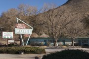 The West Walker Motel
 -
 Andryss Motel
 -
 Craft shop in Coleville
 -
 Signs in Coleville
 -
 The Sierra Retreat Motel


See also
[edit]References
[edit]- ^ a b "2022 U.S. Gazetteer Files: California". United States Census Bureau. Retrieved November 1, 2022.
- ^ a b c U.S. Geological Survey Geographic Names Information System: Coleville, California
- ^ a b "P1. Race – Coleville CDP, California: 2020 DEC Redistricting Data (PL 94-171)". U.S. Census Bureau. Retrieved November 1, 2022.
- ^ a b c Durham, David L. (1998). California's Geographic Names: A Gazetteer of Historic and Modern Names of the State. Clovis, California: Word Dancer Press. p. 1155. ISBN 1-884995-14-4.
- ^ a b c d e Report of the Mono County Planning Department regarding the Antelope Valley Fire Protection District Archived 2009-06-21 at the Wayback Machine
- ^ Climate Summary for Coleville, California
- ^ Report of the Mono County Planning Department regarding the Antelope Valley Water District Archived 2009-06-21 at the Wayback Machine
- ^ a b c "Mono County Office of Education". Archived from the original on July 14, 2009. Retrieved June 26, 2009.
- ^ "2010 Census of Population - Population and Housing Unit Counts - California" (PDF). United States Census Bureau.
- ^ a b c d e "Coleville CDP, California; DP1: Profile of General Population and Housing Characteristics - 2020 Census of Population and Housing". US Census Bureau. Retrieved June 11, 2025.
- ^ "Coleville CDP, California; P16: Household Type - 2020 Census of Population and Housing". US Census Bureau. Retrieved June 11, 2025.
- ^ "Final Maps | California Citizens Redistricting Commission". Retrieved August 7, 2025.
- ^ "California's 3rd Congressional District - Representatives & District Map". Civic Impulse, LLC. Retrieved August 7, 2025.
External links
[edit]Municipalities and communities of Mono County, California, United States | ||
|---|---|---|
| Town | 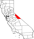 | |
| Census-designated places | ||
| Unincorporated communities | ||
| Indian reservations | ||
| Former settlements | ||
| International | |
|---|---|
| National | |
| Other | |