
Coaldale, Colorado
Coaldale, Colorado | |
|---|---|
 An abandoned bridge over the Arkansas River in Coaldale | |
 Location of the Coaldale CDP in Fremont County, Colorado. | |
 Coaldale Location of the Coaldale CDP, Colorado.  Coaldale Coaldale (Colorado) | |
| Coordinates: 38°21′56″N 105°45′28″W / 38.3656°N 105.7578°W[2] | |
| Country | United States |
| State | Colorado |
| County | Fremont[1] |
| Founded | 1891 |
| Government | |
| • Type | unincorporated community |
| • Body | Fremont County[1] |
| Area | |
• Total | 31.048 sq mi (80.413 km2) |
| • Land | 31.048 sq mi (80.413 km2) |
| • Water | 0.000 sq mi (0.000 km2) |
| Elevation | 6,552 ft (1,997 m) |
| Population | |
• Total | 343 |
| • Density | 11/sq mi (4.3/km2) |
| Time zone | UTC−07:00 (MST) |
| • Summer (DST) | UTC−06:00 (MDT) |
| ZIP code[5] | 81222 |
| Area code | 719 |
| GNIS place ID | 204773 |
| GNIS town ID | 2583223 |
| FIPS code | 08-15440 |
Coaldale is a census-designated place (CDP) and post office located in Fremont County, Colorado, United States. The CDP is a part of the Cañon City, CO Micropolitan Statistical Area. The Coaldale post office has the ZIP Code 81222.[5] At the United States Census 2020, the population of the Coaldale CDP was 343.[4] The unincorporated community is a part of the Cañon City, CO Micropolitan Statistical Area, the Pueblo-Cañon City, CO Combined Statistical Area, and the Front Range Urban Corridor.
History
[edit]The Coaldale, Colorado, post office opened on February 16, 1891.[6]
Geography
[edit]Coaldale is located in southwestern Fremont County. It is bordered to the northwest by the community of Howard. The northeastern edge of the CDP follows the Arkansas River, and U.S. Route 50 follows the river through the CDP. Cañon City, the county seat, is 37 miles (60 km) to the east (downriver), while Salida is 21 miles (34 km) northwest (upriver).
The Coaldale CDP has an area of 19,870 acres (80.413 km2), all land.[3] The CDP extends southwest out of the Arkansas River valley up into San Isabel National Forest and the Sangre de Cristo Range. The southeastern edge of the CDP follows the Hayden Creek valley up to Hayden Pass; the southwestern edge follows the Saguache County line along the crest of the Sangre de Cristos; and the northwestern edge follows Stout Creek and Kerr Gulch Road back down to the Arkansas River valley.
Demographics
[edit]The United States Census Bureau initially defined the Coaldale CDP for the United States Census 2010.
| Year | Pop. | ±% |
|---|---|---|
| 2010 | 255 | — |
| 2020 | 343 | +34.5% |
| Source: United States Census Bureau | ||
See also
[edit]- Cañon City, CO Micropolitan Statistical Area
- Pueblo-Cañon City, CO Combined Statistical Area
- Front Range Urban Corridor
- List of census-designated places in Colorado
- List of populated places in Colorado
- List of post offices in Colorado
References
[edit]- ^ a b "Colorado Counties". Colorado Department of Local Affairs. Retrieved July 17, 2025.
- ^ a b "Coaldale, Colorado". Geographic Names Information System. United States Geological Survey, United States Department of the Interior. Retrieved July 17, 2025.
- ^ a b "State of Colorado Census Designated Places - BAS20 - Data as of January 1, 2020". United States Census Bureau. Retrieved December 22, 2020.
- ^ a b United States Census Bureau. "Coaldale CDP, Colorado". Retrieved March 31, 2023.
- ^ a b "ZIP Code Lookup". United States Postal Service. Retrieved July 17, 2025.
- ^ Bauer, William H.; Ozment, James L.; Willard, John H. (1990). Colorado Post Offices 1859–1989. Golden, Colorado: Colorado Railroad Historical Foundation. ISBN 0-918654-42-4.
External links
[edit]- State of Colorado
- Coaldale @ Colorado.com
- Coaldale @ UncoverColorado.com
- Coaldale, Colorado Mining Claims And Mines
- Fremont County website
Municipalities and communities of Fremont County, Colorado, United States | ||
|---|---|---|
| Cities | 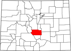 | |
| Towns | ||
| CDPs | ||
| Unincorporated communities | ||
| Ghost towns | ||