
Chulu East
| Chulu | |
|---|---|
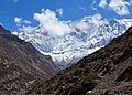
 Southwest aspect | |
| Highest point | |
| Elevation | 6,584 m (21,601 ft)[1][2] |
| Prominence | 1,034 m (3,392 ft)[3] |
| Parent peak | Nemjung[1] |
| Isolation | 14.26 km (8.86 mi)[3] |
| Coordinates | 28°44′10″N 84°02′05″E / 28.73611°N 84.03472°E[3] |
| Geography | |
 Chulu Location in Nepal | |
 | |
| Interactive map of Chulu | |
| Country | Nepal |
| Province | Gandaki |
| District | Manang |
| Protected area | Annapurna Conservation Area[1] |
| Parent range | Himalayas Damodar Himalaya[2] |
| Climbing | |
| First ascent | 1955 |
Chulu, also known as Chulu East, is a mountain in Nepal.
Description
[edit]Chulu is a 6,584-metre (21,601-foot) glaciated summit in the Nepalese Himalayas. It is situated seven kilometres (4.3 mi) north of Manang in Gandaki Province. Precipitation runoff from the mountain's slopes drains into tributaries of the Marshyangdi River. Topographic relief is significant as the west face rises 1,300 metres (4,265 ft) in one kilometre (0.62 mi). The Annapurna Circuit traverses the valley below the west slopes of this peak. This peak along with outliers Chulu West (6,419 m) and Chulu Far East (6,060 m) are on the list of permitted trekking peaks.[4] The first ascent of the summit was made on July 23, 1955, by Heinz Steinmetz, Harald Biller, Fritz Lobbichler, and Jürgen Wellenkamp.[2] The first ascent of Chulu West was made on October 23, 1952, by Kinji Imanishi, Kazuhiko Hayashi, Sasuke Nakao, Jiro Taguchi, Masataka Takagi, and Sakuta Takebushi.[5]
Climate
[edit]Based on the Köppen climate classification, Chulu is located in a tundra climate zone with cold, snowy winters, and cool summers.[6] Weather systems are forced upwards by the Himalaya mountains (orographic lift), causing heavy precipitation in the form of rainfall and snowfall. Mid-June through early-August is the monsoon season. The months of April, May, September, and October offer the most favorable weather for viewing or climbing this peak.[7]
Gallery
[edit]-
 Southwest aspect
 -
 South aspect
 -
 Chulu West from northwest
 -
 Chulu West (6419m) viewed from Thorong La pass
 -
 South aspect of Peak 6429
 -
 South aspect of Peak 6429
 -
 Chulu from the west
 -


.jpg)


.jpg)
See also
[edit]References
[edit]- ^ a b c "Chulu, Peakvisor.com". Retrieved 3 May 2025.
- ^ a b c Chulu East Overview, Nepal Himal Peak Profile, Retrieved May 3, 2025.
- ^ a b c "Chulu East, Nepal". Peakbagger.com. Retrieved 3 May 2025.
- ^ Trekking peaks of Nepal, project-himalaya.com, Retrieved May 3, 2025.
- ^ Chulu West Overview, Nepal Himal Peak Profile, Retrieved May 3, 2025.
- ^ Peel, M. C.; Finlayson, B. L.; McMahon, T. A. (2007). "Updated world map of the Köppen−Geiger climate classification". Hydrol. Earth Syst. Sci. 11. ISSN 1027-5606.
- ^ Everest Treks: A Month By Month Review of the Best Seasons, Brinley Clark, Himalayanwonders.com, Retrieved May 3, 2025.
External links
[edit]- Chulu East: weather
Places adjacent to Chulu East | ||||||||||||||||
|---|---|---|---|---|---|---|---|---|---|---|---|---|---|---|---|---|
| ||||||||||||||||