Central and Western Lithuania Region
Central and Western Lithuania Region
Vidurio ir vakarų Lietuvos regionas (Lithuanian) | |
|---|---|
Region | |
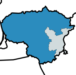
 Central and Western Lithuania Region (in blue) | |
| Country | Lithuania |
| Area | |
• Total | 55,556 km2 (21,450 sq mi) |
| Population (2023)[2] | |
• Total | 2,017,640 |
| • Density | 36/km2 (94/sq mi) |
| GDP | |
| • Total | €40.233 billion (2023) |
| • Per capita | €20,000 (2023) |
Central and Western Lithuania Region (Lithuanian: Vidurio ir vakarų Lietuvos regionas) is a subdivision of Lithuania as defined by the Nomenclature of Territorial Units for Statistics (NUTS). It is one of the two classified NUTS-2 statistical regions of Lithuania. The region encompasses an area of 55,556 km2 (21,450 sq mi) and incorporates nine counties of Lithuania except the Vilnius County. With a population of just over two million, it is the most populated of the two regions in Lithuania. Kaunas is the largest city in the region.
Classification
[edit]The country of Lithuania is organized into ten counties for administrative purposes by the amendments of Act XXI of 1996.[4] The Nomenclature of Territorial Units for Statistics (NUTS) organizes the country into two broader level sub-divisions.[5][6] These are classified as a NUTS-2 statistical regions of Lithuania, and incorporate one or more counties within it.[7][8] The new delimination was announced by the Parliament of Lithuania in 2016, and approved by European Parliament on 21 November 2016.[9] The counties form the NUTS-3 territorial units under them.[4]
Geography
[edit]Central and Western Lithuania Region incorporates an area of 55,556 km2 (21,450 sq mi).[1] The region is located in Eastern Europe, and bordered by the Baltic Sea to the west.[10] It shares international land borders with Latvia in the north, Bealrus in the south-east, Poland in the south, and Kalinigrad of Russia in the south-west.[11][12] The region has about 97 km (60 mi) of coastline of which 37 km (23 mi) face the Black Sea and the rest lies along the narrow mouth of the Curonian Lagoon extending south to Kaliningrad.[13][14] The Nemunas River enters the region from Belarus before flowing into the lagoon. The region generally consists of flat terrain except for few highlands in the west. The region consists of numerous small lakes and swamps.[13][14]
Sub-regions
[edit]Central and Western Lithuania Region incorporates nine counties of Lithuania except the Vilnius County.[7]
| # | County (media help) |
Capital | Area in km2 (rank) |
Population (2023)[15] | Pop. density (per km2) |
GDP (nominal) (billion EUR), 2023[16] |
GDP (per capita) (EUR, 2023)[16] |
Average monthly net salary (EUR), 2025-Q1[17] |
HDI (2022) [18] |
Municipalities |
|---|---|---|---|---|---|---|---|---|---|---|
| 1 | Alytus County (listen • info) |
Alytus | 5,418 | 135,367 | 25 | 1.9 | 14,300 | 1,232 | 0.846 | |
| 2 | Kaunas County (listen • info) |
Kaunas | 8,086 | 580,333 | 70 | 14.7 | 25,200 | 1,427 | 0.886 | |
| 3 | Klaipėda County (listen • info) |
Klaipėda | 5,222 | 336,104 | 61 | 7.6 | 22,500 | 1,356 | 0.880 | |
| 4 | Marijampolė County (listen • info) |
Marijampolė | 4,466 | 135,891 | 31 | 1.3 | 14,800 | 1,213 | 0.835 | |
| 5 | Panevėžys County (listen • info) |
Panevėžys | 7,878 | 211,652 | 27 | 3.8 | 18,200 | 1,250 | 0.850 | |
| 6 | Šiauliai County (listen • info) |
Šiauliai | 8,537 | 261,764 | 31 | 4.8 | 18,000 | 1,242 | 0.852 | |
| 7 | Tauragė County (listen • info) |
Tauragė | 4,349 | 90,652 | 21 | 1.3 | 14,800 | 1,252 | 0.825 | |
| 8 | Telšiai County (listen • info) |
Telšiai | 4,350 | 131,431 | 30 | 2.3 | 17,700 | 1,291 | 0.850 | |
| 9 | Utena County (listen • info) |
Utena | 7,191 | 125,462 | 18 | 1.8 | 14,200 | 1,220 | 0.837 |
Economy
[edit]The gross domestic product (GDP) of the region was €40.2 billion in 2023, accounting for 56% of the Lithuanian economic output.[3]
References
[edit]- ^ a b "Area by NUTS 3 regions - km2". Eurostat. Retrieved 1 June 2024.
- ^ "Population on 1 January by NUTS 2 region". Eurostat. Retrieved 1 June 2024.
- ^ a b "EU regions by GDP". Eurostat. Retrieved 18 September 2023.
- ^ a b "Counties of Lithuania". Citypopulation.de. Retrieved 23 November 2016.
- ^ "NUTS classification". Eurostat. Retrieved 1 June 2024.
- ^ "Regions in the European Union: Nomenclature of territorial units for statistics" (PDF). European Commission. Archived from the original (PDF) on 21 February 2011. Retrieved 25 November 2012.
- ^ a b "NUTS regions". Eurostat. Retrieved 1 June 2024.
- ^ "Commission Regulation (EU) 2016/2066 of 21 November 2016 amending the annexes to Regulation (EC) No 1059/2003 of the European Parliament and of the Council on the establishment of a common classification of territorial units for statistics (NUTS)". EUR-Lex. Retrieved 3 February 2019.
- ^ "Dėl Sostinės bei Vidurio ir vakarų Lietuvos regionų statistinių rodiklių skelbimo ir perdavimo Europos Komisijai (Eurostatui) - Naujienos - Lietuvos statistikos departamentas - Oficialiosios statistikos portalas". Government of Lithuania (in Lithuanian).
- ^ "Lithuania". CIA World fact book. Retrieved 1 June 2024.
- ^ "NUTS Maps: Lithuania". Eurostat. Retrieved 1 June 2024.
- ^ "Lithuania". Eurostat. Retrieved 1 June 2024.
- ^ a b "Lithuania". Government of United States. Retrieved 1 June 2024.
- ^ a b "Geography of Lithuania". Country Reports. Retrieved 1 June 2024.
- ^ "Resident population at the beginning of the year". Archived from the original on 8 May 2023. Retrieved 8 June 2023.
- ^ a b "Gross domestic product by region in 2023 M." osp.stat.gov.lt.
- ^ "Earnings in regions and municipalities".
- ^ "Sub-national HDI - Area Database - Global Data Lab". hdi.globaldatalab.org.


