
Bangli Regency
Bangli Regency
Kabupaten Bangli | |
|---|---|
| Native transcription(s) | |
| • Balinese script | ᬓᬩᬸᬧᬢᬾᬦ᭄ᬩᬂᬮᬶ |
 Coat of arms | |
| Nickname: Gumi Loloh ('Land of Jamu') | |
| Motto(s): Bhukti Mukti Bhakti (Sanskrit) ᬪᬸᬓ᭄ᬢᬶᬫᬸᬓ᭄ᬢᬶᬪᬓ᭄ᬢᬶ "Devotion by Serving God and the Homeland for the Purpose of a Just and Prosperous Society Both Physically (Bhukti) and Spiritually (Mukti)" | |
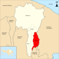
 Location within Bali | |
 Bangli Regency Location in Bali  Bangli Regency Location in Lesser Sunda Islands  Bangli Regency Location in Indonesia  Bangli Regency Location in Southeast Asia  Bangli Regency Location in Asia | |
| Coordinates: 8°17′0″S 115°20′0″E / 8.28333°S 115.33333°E | |
| Country | |
| Region | Lesser Sunda Islands |
| Province | |
| Administrative districts | |
| Established | 14 August 1958 |
| Capital | Bangli |
| Government | |
| • Regent | Sang Nyoman Sedana Arta (PDI-P) |
| • Vice Regent | I Wayan Diar |
| • Legislature | Bangli Regency Regional House of Representatives (DPRD) |
| Area | |
• Total | 520.80 km2 (201.08 sq mi) |
| Population (mid 2024 estimate)[1] | |
• Total | 259,392 |
| • Density | 500/km2 (1,300/sq mi) |
| Demographics | |
| • Ethnic groups (2010)[2] | 96.48% Balinese 2.18% Bali Aga 0.77% Javanese 0.11% Madurese 0.05% Sasak 0.04% Sundanese 0.03% Chinese 0.34% other |
| • Religion (2024)[3] |
|
| • Languages and dialects | Indonesian (official) Balinese (native); Lowland Balinese; Bangli Balinese Highland Balinese other |
| Time zone | Indonesia Central Time |
| Area code | (+62) 366 |
| HDI (2023) | |
| Website | banglikab.go.id |


Bangli Regency (Indonesian: Kabupaten Bangli; Balinese: ᬓᬩᬸᬧᬢᬾᬦ᭄ᬩᬂᬮᬶ) is the one and only landlocked regency (kabupaten) of the province of Bali, Indonesia. It covers a land area of 520.80 km2, and had a population of 259,392 in 2024. It is bordered by Badung Regency to its west, Gianyar Regency to its west and south, Buleleng Regency to its west and north, Karangasem Regency to its east and Klungkung Regency to its south. The administrative centre is at the town of Bangli.
Up until 1907, Bangli was one of the nine kingdoms of Bali.[5] The capital has a famous Hindu temple, the Kehen Temple, which dates from the 11th century. Bangli also has one village which surrounds a hill, Demulih.
Pura Dalem Galiran is 1.4 km north-west of Bangli.[6] Pura Dalem Penunggekan, 1.3 km south of the town center,[7]
Etymology
[edit]Legend
[edit]
According to the Kehen Temple Inscription stored in the Kehen Temple, it is said that in the 11th century in Bangli Village, an epidemic called kegeringan developed which caused many residents to die. The other residents who were still alive and healthy were scared to death, so they left the village in droves to avoid the epidemic. As a result, Bangli Village became empty because no one dared to live there.
King Ida Bhatara Guru Sri Adikunti Ketana who was reigning at that time tried to overcome the epidemic. After the situation recovered, the king who reigned in the year Caka 1126, on the 10th of the Bright Half Year, Maula Market Day, Kliwon, Chandra (Monday), Wuku Klurut precisely on 10 May 1204, ordered his sons and daughters named Dhana Dewi Ketu to invite the residents to return to Bangli Village to jointly build and repair their respective houses as well as hold ceremonies/yadnya in the months of Kasa, Karo, Katiga, Kapat, Kalima, Kalima, Kanem, Kapitu, Kaulu, Kasanga, Kadasa, Yjahstha and Sadha. In addition, the king also ordered all residents to increase their descendants in the Pura Loka Serana area in Bangli Village and allowed the clearing of forests to make rice fields and water channels. For that reason, at every major ceremony, the residents in Bangli Village must perform prayers. At that time, on 10 May 1204, King Idha Bhatara Guru Sri Adikunti Katana uttered a decree, namely:
Whoever does not submit and violates orders, may that person be struck by lightning without rain or suddenly fall from a bridge without cause, blind eyes without a clamp, after death his soul is tortured by Yamabala, thrown from the sky down into the fires of hell.
Starting from the King's decrees issued on 10 May 1204, that date was determined as the birthday of Bangli City. [8]
History
[edit]Protohistory
[edit]- Manikliyu, burial and Pejeng-type drum In Manikliyu (west side of Bangli Regency),[9] a burial site was excavated in 1997 and 1998 which revealed two large sarcophagi and a bronze kettle drum, representing a unique burial system thus far unknown in Indonesia.
The largest sarcophagus (length 206 cm, width 70 cm) is well preserved; the other sarcophagus (length 172 cm, width 69 cm) is partly broken. The bronze kettle drum (height 120 cm, diameter of the tympanon 77 cm) is decorated with eight stars on the tympanon, and human masks on the body. It contained human bones in flexed position that belonged to a young man of Mongoloid type, between 20 and 35 years old; the broken part of his upper face shows that he was killed by the impact of a sharp tool. The burial site also contained carnelians, beads, bronze spirals and bronze finger protectors. Some remnants broken pottery and pottery shards were also found beside the burial site and near the containers.[10]
The drum is very similar to the Pejeng type,[10] the latter referring to the Moon of Pejeng, largest single-cast bronze kettle drum known in the world, found in Pejeng (village east of Ubud, Gianyar Regency). A. Calo suggests that such kettle drums were associated with early rice cults – and cultivation – in Bali: most of them are found near sources of irrigation water (lakes, springs or weirs in rivers); their shape and decoration are reminded in modern representations of female deities associated with rice and irrigation water, the latter originating in a pre-Hindu culture and later integrated into the Hindu-Balinese panel of gods. Ritual ceremonies honouring these deities are still held to this day at places where irrigation water first enters fields (bedugul) and at crater lakes, the highest sources.[11]
- Taman Bali and Bunutin, sarcophagi At Taman Bali and Bunutin, two villages close to each other about 5 km south of Bangli,[12] five sarcophagi were known before 1973. Two more were signalled in 1973, one of which buried 3 m deep in a rice field with its lid lying nearly 1.5 m away and partly broken, and containing various bronze objects including a small shovel, a ring, arm and ankle-rings and a number of spirals different from any formerly found in sarcophagi in Bali. The other sarcophagus signalled in 1973 was found by the villagers in Bunutin in 1971, buried nearly 1.5 m deep; its lid is absent and no associated artefacts were found. One of the five sarcophagi known before 1973 is kept in Gedong Arca Museum in Bedulu; as of 1974, the others were still in their place of discovery.[13]
Establishment of the Bangli Kingdom
[edit]The story of the establishment of the Bangli Kingdom can be traced from the palm leaves in the Puri Agung Bangli and the King Purana Batur. It is said that the Bangli Kingdom was founded by I Dewa Gede Den Bencingah in the 15th century or around 1600 AD.
Initially, this kingdom was founded after the fall of the Majapahit Kingdom which had an impact on the Gelgel Kingdom (the Bali and Lombok regions). Dewa Agung Ketut, the ruler of Bali and Lombok divided his territory into vassal kingdoms.
Bangli became one of the vassal kingdoms under the direct government center of Gelgel Kingdom with the appointment of I Gusti Wija Pulada as Anglurah in Bali in 1453.
Then, in 1686 Bangli separated from Gelgel Kingdom and became a sovereign kingdom along with the rebellion of I Gusti Agung Maruti in Gelgel. Puri Bangli was founded as the center of the Bangli kingdom city by I Dewa Gde Bencingah around 1576 AD.
I Dewa Gde Bencingah was the eldest son of the king of the Bhresika Kingdom (Klungkung), I Dewa Gede Anom Oka with his consort Dewa Ayu Mas Dalem. Initially, the Bangli area was the Jarak Bang forest area.
I Dewa Gede Anom Oka ordered his son to build a palace/city in the Jarak Bang forest which would later be named Bangli.
The area covered the west of the Sungai Melangit and gathered people from the northwest, east, north, to the mountainous areas. In addition, I Dewa Gede Anom Oka also ordered to establish a sthana for the gods and Betara Toya Mas Arum. Currently, the sthana in question is known as Pura Penataran Agung Bangli.
In accordance with his father's order, I Dewa Gede Den Bencingah began to organize the Jarang Bang forest together with his followers. He then built a palace named Puri Rum, which was also used as the center of government. This area continued to be developed, until it became Bangli as it is known today.
In the early 1800s AD, the Dutch began to enter Bali and had a major impact on the existence of kingdoms in Bali. Intervention from the Dutch disrupted the governments in Bali so that several kingdoms began to face their decline.
The Fall of the Bangli Kingdom
[edit]On 26 April 1848, the King of Bangli at that time submitted a request to General Michiels to expand his power to the areas of Buleleng Kingdom, Karangasem, Mengwi, and Gianyar. The request was not immediately granted by the Dutch.
On 25 June 2849, I Dewa Gede Tangkeban was crowned King of Bangli and given power by the Dutch to rule Bangli and Buleleng. 5 years later, precisely on 15 February 1854, the king returned the Buleleng region to the Dutch on the grounds that the King of Bangli could concentrate more on securing his kingdom from attacks by the King of Gianyar and Karangasem.
The division between the kingdoms in Bali was inseparable from the intervention of the Dutch East Indies Government at that time. There were many rebellions against the Dutch such as Puputan Badung in 1906 and Puputan Klungkung in 1909.
Shortly after, the Bangli Kingdom declared its submission to the Dutch, until finally the entire region in Bali was controlled by the Dutch East Indies Government.
The list of kings in the Bangli Kingdom is as follows:
- Dewa Gede Tangkeban I (from Nyalian-1804)
- God Rahi (1804–1815)
- Dewa Gede Tangkeban II (1815–1833) [son of Dewa Gede Tangkeban I]
- Dewa Gede Tangkeban III (1833–1875) [son of Dewa Gede Tangkeban II]
- Dewa Gede Oka (1875–1880) [son of *Dewa Gede Tangkeban III]
- Dewa Gede Ngurah (1881–1892) [brother of Dewa Gede Oka]
- Dewa Gede Cokorda (1894–1911) [brother of Dewa Gede Ngurah]
- Dewa Gede Rai (regent 1913–1925) [brother of Dewa Gede Cokorda]
- Dewa Gede Taman (regent 1925–1930) [grandson of Dewa Gede Tangkaban III]
- Dewa Putu Bukian (caretaker 1930–1931) [grandson of Dewa Gede Tangkaban III]
- Anak Agung Ketut Ngurah (ruler, used the title Anak *Agung, 1931–1950; died 1961) [son of Dewa Gede Cokorda]
Bangli joined the Unitary State of the Republic of Indonesia in 1950.[14]
Government and politics
[edit]| No. | Regent | Start of office | End of office | Vice Regent | ||
|---|---|---|---|---|---|---|
| 10 |  Sang Nyoman Sedana Arta Sang Nyoman Sedana Arta
|
26 February 2021 | Incumbent |  I Wayan Diar I Wayan Diar
| ||
Parliament
[edit]
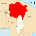
Administrative districts
[edit]The Regency is divided into four districts (kecamatan), listed below with their areas and their populations at the 2010 Census[15] and the 2020 Census,[16] together with the official estimates as at mid 2024.[1] The most northern district – Kintamani, which is the primary highland region for the cultivation of arabica coffee – occupies over 70% of the regency's area and has 43% of its population. The table also includes the locations of the district administrative centres, the number of administrative villages in each district (totaling 68 rural desa and 4 urban kelurahan – the latter all in Bangli District), and its postal codes.
-
 Susut district
 -
 Bangli district
 -
 Tembuku district
 -
 Kintamani district


| Kode Wilayah |
Name of District (kecamatan) |
Area in km2 |
Pop'n 2010 Census |
Pop'n 2020 Census |
Pop'n mid 2024 Estimate |
Admin centre |
No. of villages |
Post code |
|---|---|---|---|---|---|---|---|---|
| 51.06.01 | Susut | 49.3 | 43,202 | 48,682 | 49,658 | Susut | 9 | 80661 |
| 51.06.02 | Bangli | 56.3 | 48,267 | 54,438 | 54,283 | Bangli | 9 | 80611 – 80614 |
| 51.06.03 | Tembuku | 48.3 | 33,806 | 43,138 | 43,736 | Tembuku | 6 | 80671 |
| 51.06.04 | Kintamani | 366.9 | 90,078 | 112,463 | 111,715 | Kintamani | 48 | 80652 |
| Totals | 520.8 | 215,353 | 258,731 | 259,392 | 72 |
-
 Map of Bangli Regency in Bali
 -
 Map of districts in Bangli Regency

List of districts and villages in Bangli Regency as follows:
| Code | Districts | Urban villages | Rural villages | Status | List |
|---|---|---|---|---|---|
| 51.06.02 | Bangli | 4 | 5 | Rural villages | |
| Urban villages | |||||
| 51.06.04 | Kintamani | - | 48 | Rural villages |
|
| 51.06.01 | Susut | - | 9 | Rural villages | |
| 51.06.03 | Tembuku | - | 6 | Rural villages | |
| TOTAL | 4 | 68 |
Geography
[edit]Generalities
[edit]Bangli is the only regency in Bali which is landlocked. Its northern part includes the crater in which Gunung Batur sits, and the main road from Ubud in the south to the north coast through Kintamani and around Gunung Batur's crater.[17][18]
From the Demulih hill some 3 km west of Bangli,[19] much of southern part of the island can be seen: Kuta, Nusa Dua, Gianyar and a part of Klungkung.
Climate
[edit]Bangli has a tropical rainforest climate (Köppen Af) bordering upon a tropical monsoon climate (Am) with moderate rainfall from April to October and heavy rainfall from November to March.
| Climate data for Bangli | |||||||||||||
|---|---|---|---|---|---|---|---|---|---|---|---|---|---|
| Month | Jan | Feb | Mar | Apr | May | Jun | Jul | Aug | Sep | Oct | Nov | Dec | Year |
| Mean daily maximum °C (°F) | 28.4 (83.1) |
28.5 (83.3) |
28.6 (83.5) |
29.2 (84.6) |
28.8 (83.8) |
28.1 (82.6) |
27.5 (81.5) |
27.8 (82.0) |
28.4 (83.1) |
29.3 (84.7) |
29.1 (84.4) |
28.8 (83.8) |
28.5 (83.4) |
| Daily mean °C (°F) | 24.4 (75.9) |
24.4 (75.9) |
24.3 (75.7) |
24.4 (75.9) |
24.0 (75.2) |
23.2 (73.8) |
22.8 (73.0) |
23.1 (73.6) |
23.6 (74.5) |
24.4 (75.9) |
24.5 (76.1) |
24.5 (76.1) |
24.0 (75.1) |
| Mean daily minimum °C (°F) | 20.4 (68.7) |
20.4 (68.7) |
20.1 (68.2) |
19.6 (67.3) |
19.3 (66.7) |
18.4 (65.1) |
18.2 (64.8) |
18.4 (65.1) |
18.9 (66.0) |
19.5 (67.1) |
20.0 (68.0) |
20.3 (68.5) |
19.5 (67.0) |
| Average rainfall mm (inches) | 305 (12.0) |
331 (13.0) |
208 (8.2) |
113 (4.4) |
119 (4.7) |
110 (4.3) |
128 (5.0) |
65 (2.6) |
98 (3.9) |
123 (4.8) |
176 (6.9) |
275 (10.8) |
2,051 (80.6) |
| Source: Climate-Data.org[20] | |||||||||||||
Demographics
[edit]Population
[edit]It had a population of 215,353 at the 2010 Census[15] and 258,721 at the 2020 Census;[16] the official estimate as at mid 2022 was 267,133 – comprising 134,500 males and 132,600 females.[21]
Ethnicities
[edit]

The majority of ethnic groups in Bangli are the Balinese, and Bali Aga tribes. While other ethnicities are fewer, when compared to other districts and cities in the province of Bali. Based on data from Central Bureau of Statistics in Indonesian Population Census 2010, as many as 207,779 people or 96.48% of the 215,353 people of Bangli Regency are of the Balinese ethnic group.[22] Then the Bali Aga as much as 2.18%, and several others such as the Javanese, Sasak, Madurese, and several others ethnic.[22]
The following is the population of Bangli Regency based on ethnicity in 2010:[22]
| No. | Ethnic groups | Pop. (2010) |
Pct. (%) |
|---|---|---|---|
| 1 | Balinese | 207,779 | 96.48% |
| 2 | Bali Aga | 4,702 | 2.18% |
| 3 | Javanese | 1,658 | 0.77% |
| 4 | Madurese | 236 | 0.11% |
| 5 | Sasak | 101 | 0.05% |
| 6 | Sundanese | 88 | 0.04% |
| 7 | Chinese | 66 | 0.03% |
| 8 | Others | 723 | 0.34% |
| Bangli Regency | 215,353 | 100% |
Religion
[edit]

The majority of Bangli residents are Hindu. When compared to other districts and cities in the province of Bali, the population of Bangli is more Hindu, while the population with other religions is smaller. Data from the Ministry of Home Affairs in mid-2023, the population that adheres to Hindu is 98.72%. The rest adhere to Islam religion as much as 1.00%, then Christianity as much as 0.15%, Buddhism as much as 0.11% and Confucianism as much as 0.02%.[23][24][25]
Tourism
[edit]Tourism is the main economic sector of Bangli Regency, tourism is the mainstay of the district's economy. There are several tourist attractions in Bangli district, including:
- Penelokan Hot Springs
- Batur Geopark Museum
- Mount Batur Caldera
- Demulih Hill
- Dusun Kuning Waterfall
- Slau Waterfall
- Tukad Cepung Waterfall Archived 9 August 2016 at the Wayback Machine
- Batur Lake
- Penglipuran Village
- Batukaang Ancient Village
- Pura Dalem Jawa (Langgar)
- Kehen Temple
- Trunyan
- Krisik Waterfall
Gallery
[edit]-

-
 Mount Batur Caldera
 -

-
 Penglipuran street
 -

-


.jpg)


References
[edit]- ^ a b Badan Pusat Statistik, Jakarta, 28 February 2025, Kabupaten Bangli Dalam Angka 2025 (Katalog-BPS 1102001.5106)
- ^ "Peta Sebaran Penduduk Menurut Suku Bangsa Provinsi Bali : Hasil Sensus Penduduk 2000 Dan 2010".
- ^ "Penduduk Provinsi Bali Menurut Agama yang Dianut Hasil Sensus Penduduk 1971, 2000, 2010, dan 2024 – Tabel Statistik".
- ^ "Indeks Pembangunan Manusia Provinsi Bali Menurut Kabupaten/Kota 2021–2023". www.bali.bps.go.id. Retrieved 6 December 2023.
- ^ The nine kingdoms were Gelgel (the original kingdom, based near present-day Klungkung), Klungkung, Karangasem, Gianyar, Badung, Bangli, Buleleng Mengwi and Tabanan. For details, see Adrian Vickers, 2012, Bali, A Paradise Created, Tuttle publishing.
- ^ "Pura Dalem Galiran, map". google.fr/maps.
- ^ Pura Dalem Penunggekan, view of the entrance on street camera.
- ^ info@banglikab.or.id. "History of Bangli | Bangli Regency Government". Web Regency Bangli. Archived from the original on 23 October 2018. Retrieved 23 October 2018.
- ^ "Manikliyu, map". openstreetmap. 18 February 2019.
- ^ a b Sutaba, I Made (1999). "Discovery of Late Prehistoric Burial Systems in Bali". SPAFA Journal. 9 (1): 15–18. Retrieved 9 May 2024.
- ^ Calo, Ambra (October 2008). "Pejeng Type Bronze Drums and their Possible Role in Early Rice Cults in Bali". fas.nus.edu.sg. Archived from the original on 26 July 2009. Retrieved 9 May 2024.
- ^ "Taman Bali and Bunutin (Blangli Regency), map". openstreetmap. 31 July 2021.
- ^ Sutaba, I Made (1974). "Newly discovered sarcophagi in Bali". Archipel. 7 (7): 133–138. doi:10.3406/arch.1974.1163.
- ^ History of the Establishment and Fall of the Bangli Kingdom Names of Kings from Time to Timedetikbali.com Accessed 2 February 2025
- ^ a b Biro Pusat Statistik, Jakarta, 2011.
- ^ a b Badan Pusat Statistik, Jakarta, 2021.
- ^ "Bangli Regency, map". openstreetmap.org. 19 April 2025.
- ^ Dalton, Bill (1988). Indonesia Handbook, 4th edition, p. 435.
- ^ "Demulih hill, map". openstreetmap.org. 16 November 2017.
- ^ "Climate: Bangli". Climate-Data.org. Retrieved 17 November 2020.
- ^ Badan Pusat Statistik, Jakarta, 2023, Kabupaten Bangli Dalam Angka 2023 (Katalog-BPS 1102001.5106)
- ^ a b c "Population Distribution Map According to Ethnic Groups in Bali Province" (pdf). bali.bps.go.id. 15 January 2015. pp. 9, 11. Archived from the original on 30 June 2022. Retrieved 24 September 2022.
- ^ Cite error: The named reference
DUKCAPILwas invoked but never defined (see the help page). - ^ "Population According to Region and Religion Adhered to in Bangli Regency". Central Bureau of Statistics. Archived from the original on 8 March 2023. Retrieved 21 January 2021.
- ^ "ArcGIS Web Application". Archived from the original on 5 August 2021. Retrieved 18 September 2021.
External links
[edit] East Bali travel guide from Wikivoyage
 Media related to Bangli Regency at Wikimedia Commons
- (in Indonesian) Official website
- Official tourism site Archived 6 September 2005 at the Wayback Machine
- Profile at bali.go.id Archived 14 December 2006 at the Wayback Machine
- BPS Bangli Regency
- Tourist Attractions in Bali
- List of Entrance Ticket Prices for Tourist Attractions in Bangli
- Cerita Kaki Gatal – Indonesia Travel Blog {{Webarchive|url=http
| International | |
|---|---|
| National | |
| Geographic | |
| Other | |