
Sinjsko Polje
| Sinjsko Polje | |
|---|---|
 View from the Cetina River bank | |
 | |
| Floor elevation | 295–301 m (968–988 ft) |
| Area | 64 km2 (25 sq mi) |
| Geography | |
| Country | Croatia |
| State/Province | Split-Dalmatia County |
| Population center | Sinj |
| Coordinates | 43°41′N 16°42′E / 43.68°N 16.7°E |
| Mountain range | Dinaric Alps |
| Rivers | Cetina |
| Location | |
 | |
Sinjsko Polje (lit. 'Field of Sinj') is a polje (karstic field) in the inner Dalmatia region of Croatia, the fifth largest in Croatia, covering an area of 64 square kilometres (25 sq mi).[1] The Cetina River flows along the edge of the field, and receives a number of tributaries.[2]
The field is 12 km long and up to 7 km wide. It is enclosed by the slopes of Visoka, Svilaja, Dinara, and Kamešnica from west to northeast, and some lower hills to the southwest. In the past, the field was periodically flooded because of the abundant flow of water from the river and numerous springs, but the construction of drainage canals and interventions on the Cetina, with the regulated artificial Peruća Lake located upstream, enabled the development of agriculture.[2] The canals are in total 150 km long; even though around 20 km2 could be irrigated, only a quarter of this area is systematically irrigated.[3] Conditions for a stable, high-yielding and crop-intensive production are yet to be achieved.[3]
The climate is Mediterranean-mountainous, with strong winter gusts of dry and cold air, frequent temperature inversions, summer droughts, and occasional heavy rainfall.[2]
There are several fruitful archaeological sites from the Neolithic period along the Cetina at Sinjsko Polje. Remains of huts and valuable, rare finds have been found, which show that the Cetina River was an important area in the interior of the Adriatic hinterland since prehistoric times.[4][5]
Several settlements are located along the edge of the field: Sinj as the center of the region of Cetinska Krajina, Glavice, Brnaze, Hrvace, Otok, Trilj, Košute, Turjaci.[2]
The field hosts a grass strip that was once the main airport for the city of Split. Nowadays, the airport is used for gliding and parachuting.[2]
Gallery
[edit]-
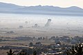 Morning mist over Sinjsko polje
 -
 Cetina River at Sinjsko polje


References
[edit]- ^ Ostroški, Ljiljana, ed. (December 2015). Statistički ljetopis Republike Hrvatske 2015 [Statistical Yearbook of the Republic of Croatia 2015] (PDF). Statistical Yearbook of the Republic of Croatia (in Croatian and English). Vol. 47. Zagreb: Croatian Bureau of Statistics. p. 51. ISSN 1333-3305. Retrieved 27 December 2015.
- ^ a b c d e "Sinjsko polje". Hrvatska enciklopedija (in Croatian). Leksikografski zavod Miroslav Krleža. Retrieved 2025-04-12.
- ^ a b Ljubenkov, Igor; Cindrić Kalin, Ksenija (2016). "Evaluation of drought using standardised precipitation and flow indices and their correlations on an example of Sinjsko polje". Journal of the Croatian Association of Civil Engineers. 68 (2): 135–143. doi:10.14256/JCE.1337.2015.
- ^ Milošević, Ante (2008). "Cetinski adorant". Archaeologia Adriatica (in Croatian). 2 (1): 275–288. ISSN 1846-4807.
- ^ Delonga, Vedrana (1991). "The results of recent researches of medieval sites in Dalmatia". Starohrvatska prosvjeta (in Croatian). III (21): 15. ISSN 0351-4536.
This Split-Dalmatia County geography article is a stub. You can help Wikipedia by expanding it. |
Dinaric Alps' karst fields | ||
|---|---|---|
| Bosnia and Herzegovina |  | |
| Croatia | ||
| Kosovo | ||
| Montenegro | ||
| Serbia | ||
| Slovenia | ||