
Niederer Fläming
(Redirected from Niederer Flaming)
Niederer Fläming | |
|---|---|
 Wiepersdorf manor | |
Location of Niederer Fläming within Teltow-Fläming district 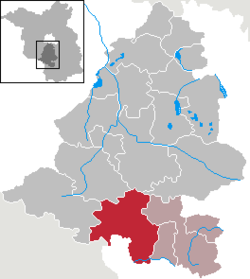 | |
 Niederer Fläming  Niederer Fläming | |
| Coordinates: 51°54′N 13°12′E / 51.900°N 13.200°E | |
| Country | Germany |
| State | Brandenburg |
| District | Teltow-Fläming |
| Municipal assoc. | Dahme/Mark |
| Subdivisions | 23 Ortsteile |
| Government | |
| • Mayor (2024–29) | Matthias Wäsche[1] |
| Area | |
• Total | 186.11 km2 (71.86 sq mi) |
| Highest elevation | 132 m (433 ft) |
| Lowest elevation | 80 m (260 ft) |
| Population (2023-12-31)[2] | |
• Total | 3,018 |
| • Density | 16/km2 (42/sq mi) |
| Time zone | UTC+01:00 (CET) |
| • Summer (DST) | UTC+02:00 (CEST) |
| Postal codes | 14913 |
| Dialling codes | 033746 |
| Vehicle registration | TF |
| Website | www.gemeinde-niederer-flaeming.de |
Niederer Fläming (German pronunciation: [ˈniːdəʁɐ ˈflɛːmɪŋ], lit. 'Lower Fläming') is a municipality in the Teltow-Fläming district of Brandenburg, Germany.
Demography
[edit]-
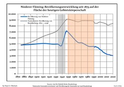 Development of Population since 1875 within the Current Boundaries (Blue Line: Population; Dotted Line: Comparison to Population Development of Brandenburg state; Grey Background: Time of Nazi rule; Red Background: Time of Communist rule)
 -
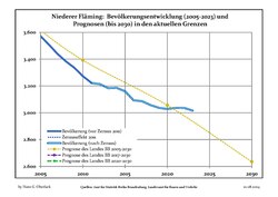 Recent Population Development and Projections (Population Development before Census 2011 (blue line); Recent Population Development according to the Census in Germany in 2011 (blue bordered line); Projection by the Brandenburg state for 2005-2030 (yellow line); Projection by the Brandenburg state for 2014-2030 (red line)


|
|
|
References
[edit]- ^ Landkreis Teltow-Fläming Wahl der Bürgermeisterin / des Bürgermeisters. Retrieved 10 July 2024.
- ^ "Bevölkerungsstand im Land Brandenburg Dezember 2023] (Fortgeschriebene amtliche Einwohnerzahlen, basierend auf dem Zensus 2022)". Amt für Statistik Berlin-Brandenburglanguage=German.
- ^ Detailed data sources are to be found in the Wikimedia Commons.Population Projection Brandenburg at Wikimedia Commons
Towns and municipalities in Teltow-Fläming | ||
|---|---|---|
 | ||
| International | |
|---|---|
| National | |
This Brandenburg location article is a stub. You can help Wikipedia by expanding it. |