
File:Pacific crest trail route overview.png
Size of this preview: 291 × 600 pixels. Other resolutions: 116 × 240 pixels | 233 × 480 pixels | 372 × 768 pixels | 497 × 1,024 pixels | 1,446 × 2,980 pixels.
Original file (1,446 × 2,980 pixels, file size: 1.79 MB, MIME type: image/png)
| This is a file from the Wikimedia Commons. Information from its description page there is shown below. Commons is a freely licensed media file repository. You can help. |
Summary
| Description |
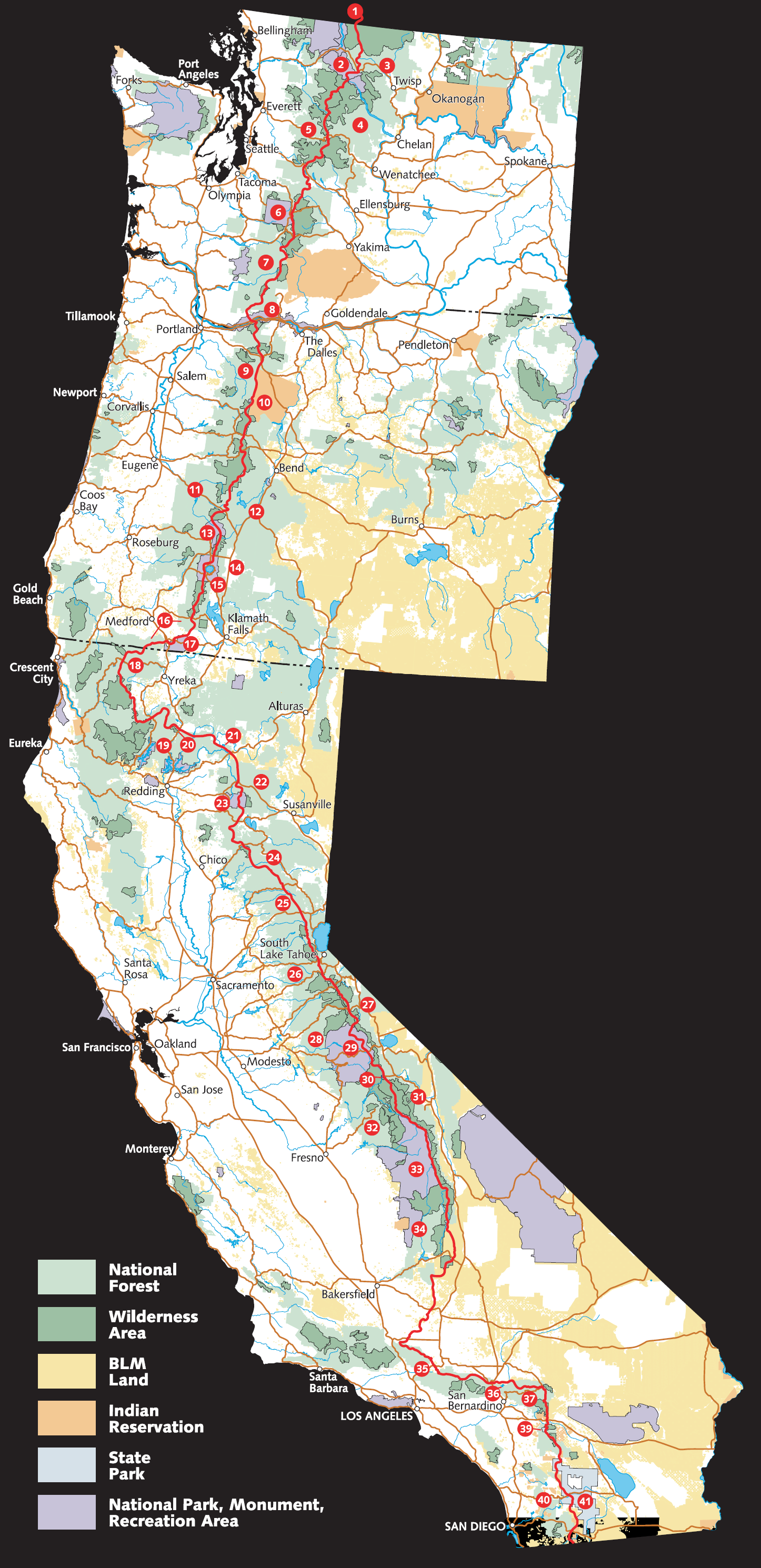
English: Schematic overview of the Pacific Crest Trail route, adjacent federal lands, and landscape. (BLM stands for Bureau of Land Management.) |
| Source | Adapted from https://web.archive.org/web/20060624223438/http://www.fs.fed.us/pct/pdf/Large_PCT_Map.pdf |
| Author | w:USFS and EncMstr |
Licensing
This image is a work of the Forest Service of the United States Department of Agriculture. As a work of the U.S. federal government, the image is in the public domain.
|
File history
Click on a date/time to view the file as it appeared at that time.
| Date/Time | Thumbnail | Dimensions | User | Comment | |
|---|---|---|---|---|---|
| current | 18:17, 1 October 2006 | | 1,446 × 2,980 (1.79 MB) | EncMstr | {{Information |Description=Schematic overview of course and lands of the w:Pacific Crest Trail |Source=Adapted from http://www.fs.fed.us/pct/pdf/Large_PCT_Map.pdf |Date=2006-04-26 |Author=w:USFS and EncMstr |Permission= |other_versions= }} |
File usage
The following 2 pages use this file:
Global file usage
The following other wikis use this file:
- Usage on bg.wikipedia.org
- Usage on es.wikipedia.org
- Usage on fa.wikipedia.org
- Usage on fr.wikipedia.org
- Usage on he.wikipedia.org
- Usage on it.wikipedia.org
- Usage on nl.wikipedia.org
- Usage on no.wikipedia.org
- Usage on pl.wikipedia.org
- Usage on pt.wikipedia.org
- Usage on ro.wikipedia.org
- Usage on ru.wikipedia.org
- Usage on www.wikidata.org
- Usage on zh.wikipedia.org