
File:Khanate of Eriwan in 1809-1817.JPG
Size of this preview: 652 × 599 pixels. Other resolutions: 261 × 240 pixels | 522 × 480 pixels | 836 × 768 pixels | 1,114 × 1,024 pixels | 2,125 × 1,953 pixels.
Original file (2,125 × 1,953 pixels, file size: 433 KB, MIME type: image/jpeg)
| This is a file from the Wikimedia Commons. Information from its description page there is shown below. Commons is a freely licensed media file repository. You can help. |
| Description |
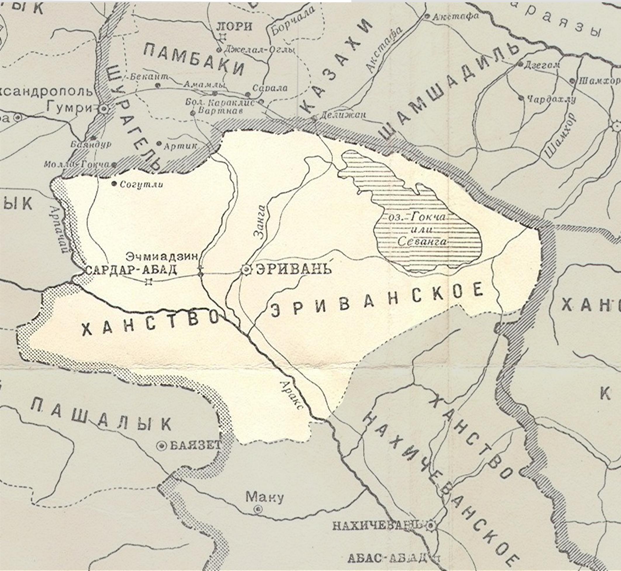
English: Persian khanate of Erivan in the map of Caucasus in 1809-1817 years
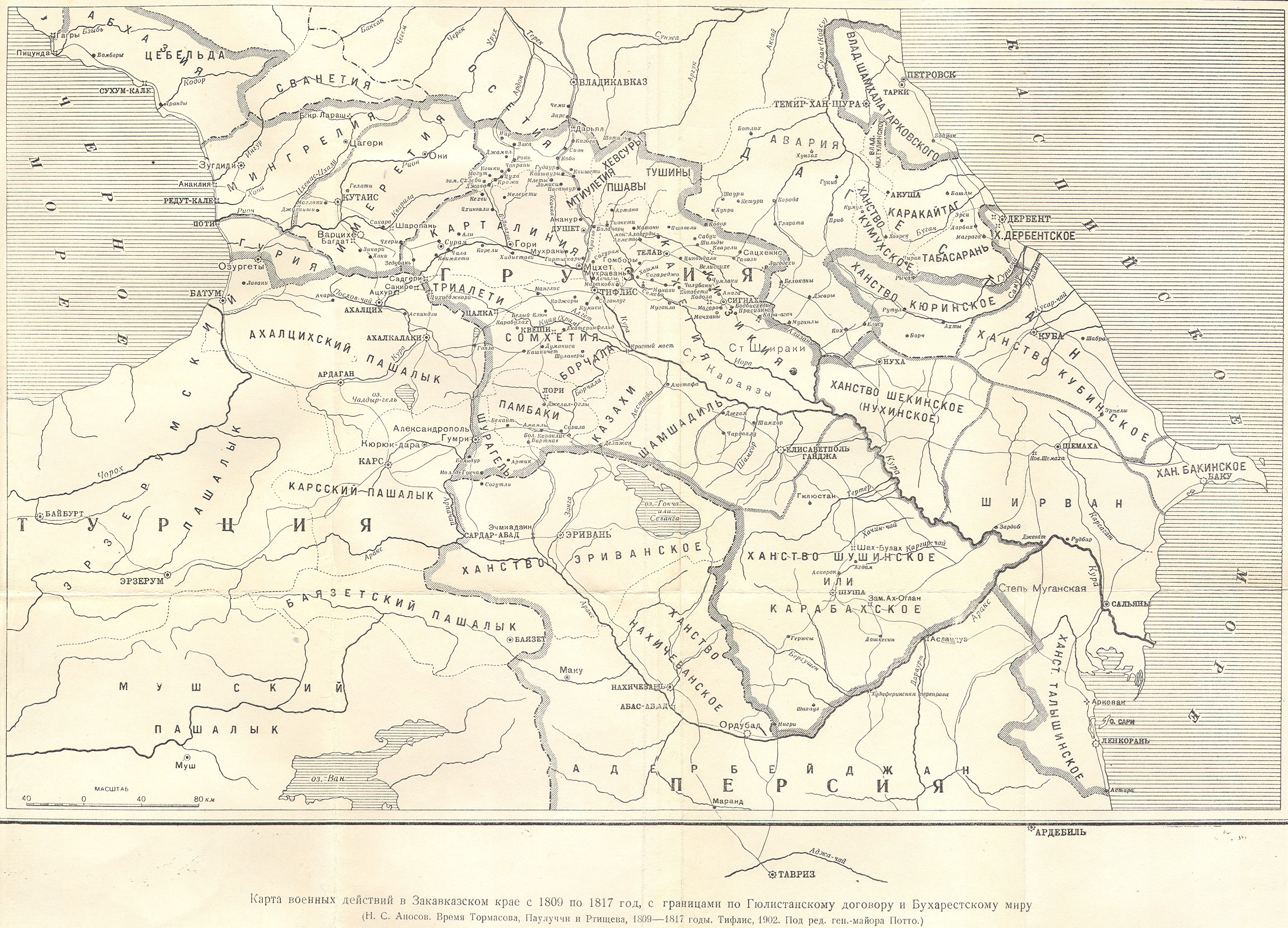
English: Map of military operations in the Transcaucasian region from 1809 to 1817(Карта военных действий в Закавказском крае с 1809 по 1817 год) |
||
| Date | 1902, Тифлис | ||
| Source |
|
||
| Author | под редакцией ген.-майора Потто. Postwork by Interfase |
|
This work is in the public domain in its country of origin and other countries and areas where the copyright term is the author's life plus 70 years or fewer. | |
| This file has been identified as being free of known restrictions under copyright law, including all related and neighboring rights. | |
File history
Click on a date/time to view the file as it appeared at that time.
| Date/Time | Thumbnail | Dimensions | User | Comment | |
|---|---|---|---|---|---|
| current | 07:09, 28 September 2010 | | 2,125 × 1,953 (433 KB) | Interfase | {{Information |Description={{en|1=Azerbaijani khanate of Erivan in the map of Caucasus in 1809-1817 years (Карта военных действий в Закавказском крае с 1809 по 1817 год) }} |Source=http://www.runivers.ru/images/d |
File usage
The following page uses this file:
Global file usage
The following other wikis use this file:
- Usage on azb.wikipedia.org
- Usage on az.wiktionary.org
- Usage on be.wikipedia.org
- Usage on fi.wikipedia.org
- Usage on ru.wikipedia.org
- Эриванское ханство
- Шаблон:Эриванское ханство
- Зангибасарский магал
- Мечеть Залхана
- Мавзолей туркменских эмиров
- Сардарский дворец
- Хусейн-хан Каджар
- Ахмед-хан Мукаддам
- Амир Гюна-хан Каджар
- Гасан Али-хан Каджар
- Мечеть Аббаса Мирзы
- Мечети Еревана
- Тахмасибгулу-хан Каджар
- Мехти-хан Касымлу
- Халил-хан Узбек
- Гусейн Али-хан
- Гуламали-хан Каджар
- Мухаммед-хан Каджар
- Мехти Кули-хан
- Гасан-хан Каджар
- Апаранский магал
- Ведибасарский магал
- Гарнибасарский магал
- Гёкчинский магал
- Гырхбулагский магал
- Дерекенд-Парченисский магал
- Деречичекский магал
- Кярбибасарский магал
- Саадлинский магал
- Сардарабадский магал
- Сеидли-Ахсаггалинский магал
- Сурмалинский магал
- Талинский магал
- Шарурский магал
- Мечеть Тапабаши
- Мечеть Реджепа-паши
- Мечеть шаха Аббаса
- Мечеть Сардара
- Мечеть Демирбулагская
- Мечеть Худабенде
- Мечеть Деф Султан
- Мечеть Мухаммеда Сертиб-хана
- Часовня Святого Апостола Анании
- Церковь Святой Богородицы (Канакер)
- Мухаммед-хан
- Кей-Хосров-хан Черкес
View more global usage of this file.