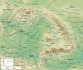
File:Geographic map of Carpathian mountains.svg
Appearance

Size of this PNG preview of this SVG file: 703 × 600 pixels. Other resolutions: 281 × 240 pixels | 563 × 480 pixels | 901 × 768 pixels | 1,201 × 1,024 pixels | 2,401 × 2,048 pixels | 3,283 × 2,800 pixels.
Original file (SVG file, nominally 3,283 × 2,800 pixels, file size: 9.78 MB)
File history
Click on a date/time to view the file as it appeared at that time.
| Date/Time | Thumbnail | Dimensions | User | Comment | |
|---|---|---|---|---|---|
| current | 12:47, 5 May 2024 |  | 3,283 × 2,800 (9.78 MB) | SpectralWiz | File uploaded using svgtranslate tool (https://svgtranslate.toolforge.org/). Added translation for mk. |
| 06:15, 31 May 2021 |  | 3,283 × 2,800 (10.6 MB) | Ikonact | lttle -> Little // Editing SVG source code using c:User:Rillke/SVGedit.js | |
| 19:57, 26 May 2021 |  | 3,283 × 2,800 (10.6 MB) | Ikonact | adjustment of two labels | |
| 13:37, 25 May 2021 |  | 3,283 × 2,800 (10.6 MB) | Ikonact | peaks | |
| 19:20, 24 May 2021 |  | 3,283 × 2,800 (10.59 MB) | Ikonact | south to 43.5° | |
| 14:46, 24 May 2021 |  | 3,283 × 2,600 (10.29 MB) | Ikonact | more labels | |
| 12:13, 24 May 2021 |  | 3,283 × 2,600 (10.28 MB) | Ikonact | labels | |
| 21:38, 23 May 2021 |  | 3,283 × 2,600 (10.28 MB) | Ikonact | small corrections as per cz discussion | |
| 21:14, 23 May 2021 |  | 3,283 × 2,600 (10.28 MB) | Ikonact | valid svg | |
| 21:03, 23 May 2021 |  | 3,283 × 2,600 (10.28 MB) | Ikonact | optimisation |
File usage
The following 5 pages use this file:
Global file usage
The following other wikis use this file:
- Usage on bg.wikipedia.org
- Usage on bs.wikipedia.org
- Usage on da.wikipedia.org
- Usage on el.wikipedia.org
- Usage on mg.wikipedia.org
- Usage on mk.wikipedia.org
- Usage on no.wikipedia.org
- Usage on qu.wikipedia.org
- Usage on sr.wikipedia.org
- Usage on tg.wikipedia.org
- Usage on uk.wikipedia.org
- Usage on www.wikidata.org


