
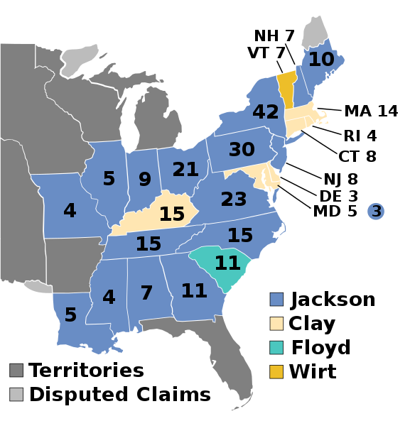
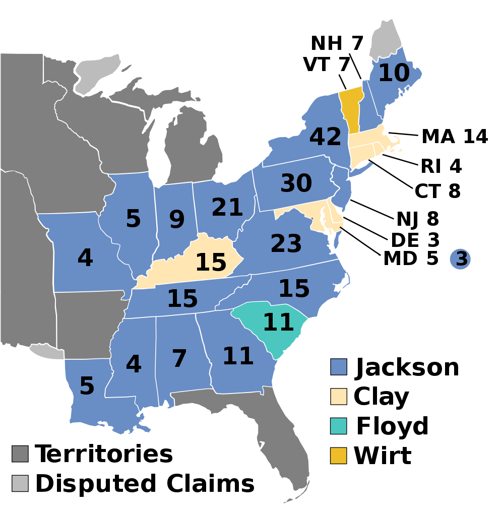
File:ElectoralCollege1832.svg

Size of this PNG preview of this SVG file: 577 × 593 pixels. Other resolutions: 234 × 240 pixels | 467 × 480 pixels | 747 × 768 pixels | 996 × 1,024 pixels | 1,993 × 2,048 pixels.
Original file (SVG file, nominally 577 × 593 pixels, file size: 30 KB)
| This is a file from the Wikimedia Commons. Information from its description page there is shown below. Commons is a freely licensed media file repository. You can help. |
| U.S. presidential election maps (SVG) |
| See also: National Atlas maps (png) |
|
1788-1789 · 1792 · 1796 · 1800 · 1804 · 1808 · 1812 · 1816 · 1820 · 1824 · 1828 · 1832 · 1836 · 1840 · 1844 · 1848 · 1852 · 1856 · 1860 · 1864 · 1868 · 1872 · 1876 · 1880 · 1884 · 1888 · 1892 · 1896 · 1900 · 1904 · 1908 · 1912 · 1916 · 1920 · 1924 · 1928 · 1932 · 1936 · 1940 · 1944 · 1948 · 1952 · 1956 · 1960 · 1964 · 1968 · 1972 · 1976 · 1980 · 1984 · 1988 · 1992 · 1996 · 2000 · 2004 · 2008 · 2012 · 2016 · 2020 · 2024 |
Summary
| Description | |
| Date | (Original); 2011-02-23 (Current) |
| Source | This image was adapted from File:ElectoralCollege1828.svg, itself adapted from File:Map of territorial growth 1775.svg and File:ElectoralCollege1964.svg (both based off File:Blank_US_Map.svg) using data from Electoral College Box Scores 1789–1996. Official website of the National Archives. (February 23, 2011), United States Of America: by H.S. Tanner, 1832. Third Edition. File:United_States_1828-1834.png, the original version uploaded by AndyHogan14 and the National Atlas of the United States |
| Author |
Cg-realms (current) AndyHogan14 (original) |
| Other versions | File:ElectoralCollege1832-Large.png |
| SVG development | W3C-validity not checked. |
Licensing
| I, the copyright holder of this work, release this work into the public domain. This applies worldwide. In some countries this may not be legally possible; if so: I grant anyone the right to use this work for any purpose, without any conditions, unless such conditions are required by law. |
File history
Click on a date/time to view the file as it appeared at that time.
| Date/Time | Thumbnail | Dimensions | User | Comment | |
|---|---|---|---|---|---|
| current | 01:36, 15 March 2025 | | 577 × 593 (30 KB) | The Squirrel Conspiracy | Reverted to version as of 03:21, 27 February 2025 (UTC) |
| 16:08, 13 March 2025 | No thumbnail | 577 × 593 (109 KB) | GroverCleveland4 | Reverted to version as of 00:57, 24 February 2011 (UTC) | |
| 16:07, 13 March 2025 | No thumbnail | 577 × 593 (107 KB) | GroverCleveland4 | Reverted to version as of 07:16, 14 November 2016 (UTC) | |
| 16:07, 13 March 2025 | No thumbnail | 1,020 × 593 (89 KB) | GroverCleveland4 | Reverted to version as of 01:53, 1 January 2009 (UTC) | |
| 03:21, 27 February 2025 | No thumbnail | 577 × 593 (30 KB) | Interesting 2752 | Reverting mass reversion to old version of map | |
| 20:05, 26 February 2025 | No thumbnail | 577 × 593 (109 KB) | Ecotto29200 | Reverted to version as of 00:36, 24 February 2011 (UTC) | |
| 11:32, 19 November 2024 |  | 577 × 593 (30 KB) | Arnapha | Clearer borders | |
| 15:49, 21 February 2019 |  | 577 × 593 (172 KB) | Stafyfan53 | fix | |
| 22:35, 11 July 2018 |  | 577 × 593 (173 KB) | Wow | fix | |
| 19:00, 11 July 2018 |  | 577 × 593 (173 KB) | Wow | wirt |
File usage
The following 43 pages use this file:
- 1832 United States elections
- 1832 United States presidential election
- 1832 United States presidential election in Alabama
- 1832 United States presidential election in Connecticut
- 1832 United States presidential election in Delaware
- 1832 United States presidential election in Georgia
- 1832 United States presidential election in Illinois
- 1832 United States presidential election in Indiana
- 1832 United States presidential election in Kentucky
- 1832 United States presidential election in Louisiana
- 1832 United States presidential election in Maine
- 1832 United States presidential election in Maryland
- 1832 United States presidential election in Massachusetts
- 1832 United States presidential election in Mississippi
- 1832 United States presidential election in Missouri
- 1832 United States presidential election in New Hampshire
- 1832 United States presidential election in New Jersey
- 1832 United States presidential election in New York
- 1832 United States presidential election in North Carolina
- 1832 United States presidential election in Ohio
- 1832 United States presidential election in Pennsylvania
- 1832 United States presidential election in Rhode Island
- 1832 United States presidential election in South Carolina
- 1832 United States presidential election in Tennessee
- 1832 United States presidential election in Vermont
- 1832 United States presidential election in Virginia
- Electoral vote changes between United States presidential elections
- Henry Clay
- List of United States presidential election results by state
- Presidency of Andrew Jackson
- United States presidential election
- Talk:1832 United States presidential election
- User:1aWIKIAL1,/sandbox
- User:DukeOfDelTaco/U.S. Presidential Elections
- User:Falcaorib/United States presidential elections
- User:Jnestorius/1832 United States presidential election in Maryland
- User:RapidsLurker15/United States presidential elections
- Template:1832 United States presidential election imagemap
- Template:State results of the 1832 U.S. presidential election
- Draft:2040 United States presidential election
- Draft:2060 United States presidential election
- Draft:2064 United States presidential election
- Draft:2076 United States presidential election
Global file usage
The following other wikis use this file:
- Usage on ckb.wikipedia.org
- Usage on da.wikipedia.org
- Usage on de.wikipedia.org
- Usage on el.wikipedia.org
- Usage on es.wikipedia.org
- Usage on fi.wikipedia.org
- Usage on fr.wikipedia.org
- Usage on he.wikipedia.org
- Usage on it.wikipedia.org
- Usage on ja.wikipedia.org
- Usage on ko.wikipedia.org
- Usage on nl.wikipedia.org
- Usage on no.wikipedia.org
- Usage on pl.wikipedia.org
- Usage on pt.wikipedia.org
- Usage on ro.wikipedia.org
- Usage on ru.wikipedia.org
- Usage on sr.wikipedia.org
- Usage on sv.wikipedia.org
- Usage on sw.wikipedia.org
- Usage on tr.wikipedia.org
- Usage on uk.wikipedia.org
- Usage on ur.wikipedia.org
- Usage on vi.wikipedia.org
- Usage on www.wikidata.org
- Usage on zh.wikipedia.org