
File:EU28-2013 European Union map.svg

Size of this PNG preview of this SVG file: 680 × 540 pixels. Other resolutions: 302 × 240 pixels | 605 × 480 pixels | 967 × 768 pixels | 1,280 × 1,016 pixels | 2,560 × 2,033 pixels.
Original file (SVG file, nominally 680 × 540 pixels, file size: 783 KB)
| This is a file from the Wikimedia Commons. Information from its description page there is shown below. Commons is a freely licensed media file repository. You can help. |
Summary
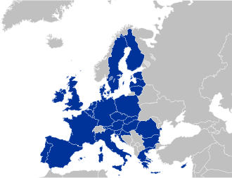
| Description |
Deutsch:
Español:
Français :
Italiano: |
| Date | (UTC) |
| Source | Own work |
| Author | Kolja21 |
| Other versions |
|


Licensing
I, the copyright holder of this work, hereby publish it under the following licenses:

|
Permission is granted to copy, distribute and/or modify this document under the terms of the GNU Free Documentation License, Version 1.2 or any later version published by the Free Software Foundation; with no Invariant Sections, no Front-Cover Texts, and no Back-Cover Texts. A copy of the license is included in the section entitled GNU Free Documentation License. |
This file is licensed under the Creative Commons Attribution 3.0 Unported license.
- You are free:
- to share – to copy, distribute and transmit the work
- to remix – to adapt the work
- Under the following conditions:
- attribution – You must give appropriate credit, provide a link to the license, and indicate if changes were made. You may do so in any reasonable manner, but not in any way that suggests the licensor endorses you or your use.
You may select the license of your choice.
File history
Click on a date/time to view the file as it appeared at that time.
| Date/Time | Thumbnail | Dimensions | User | Comment | |
|---|---|---|---|---|---|
| current | 21:39, 10 January 2025 | | 680 × 540 (783 KB) | ImStevan | Fix blue |
| 17:51, 29 December 2024 |  | 680 × 540 (783 KB) | ImStevan | + Kosovo | |
| 17:41, 29 December 2024 |  | 680 × 540 (781 KB) | ImStevan | More accurate borders, fixed Monaco's shoreline, Faroe Islands were never in the EU | |
| 05:21, 1 February 2020 |  | 680 × 520 (343 KB) | Kolja21 | Reverted to version as of 22:49, 23 June 2013 (UTC) | |
| 02:48, 1 February 2020 |  | 680 × 520 (347 KB) | Ricardomarins29 | United Kingdom removed after Brexit | |
| 22:49, 23 June 2013 |  | 680 × 520 (343 KB) | Kolja21 | Country codes | |
| 18:29, 14 June 2013 |  | 680 × 520 (345 KB) | Masterdeis | Ajout des micro-États. | |
| 00:54, 25 May 2013 |  | 680 × 520 (342 KB) | Kolja21 | Kosovo | |
| 00:46, 25 May 2013 |  | 680 × 520 (372 KB) | Kolja21 | {{Information |Description ={{en|1=European Union (EU 27)}} |Source ={{own}} |Author =Kolja21 |Date = |Permission = |other_versions = }} |
File usage
The following page uses this file:
Global file usage
The following other wikis use this file:
- Usage on ca.wikipedia.org
- Usage on cs.wikipedia.org
- Usage on de.wikipedia.org
- Usage on et.wikipedia.org
- Usage on fa.wikipedia.org
- Usage on fr.wikipedia.org
- Usage on fr.wikiversity.org
- Usage on fr.wiktionary.org
- Usage on hu.wikipedia.org
- Usage on nl.wikipedia.org
- Usage on pt.wikipedia.org
- Usage on sr.wikipedia.org
- Usage on www.wikidata.org
- Usage on zh.wikipedia.org