
File:DC Metro Map 2013.svg

Size of this PNG preview of this SVG file: 566 × 599 pixels. Other resolutions: 227 × 240 pixels | 453 × 480 pixels | 726 × 768 pixels | 967 × 1,024 pixels | 1,935 × 2,048 pixels | 1,539 × 1,629 pixels.
Original file (SVG file, nominally 1,539 × 1,629 pixels, file size: 4.48 MB)
| This is a file from the Wikimedia Commons. Information from its description page there is shown below. Commons is a freely licensed media file repository. You can help. |
Summary
| Description |
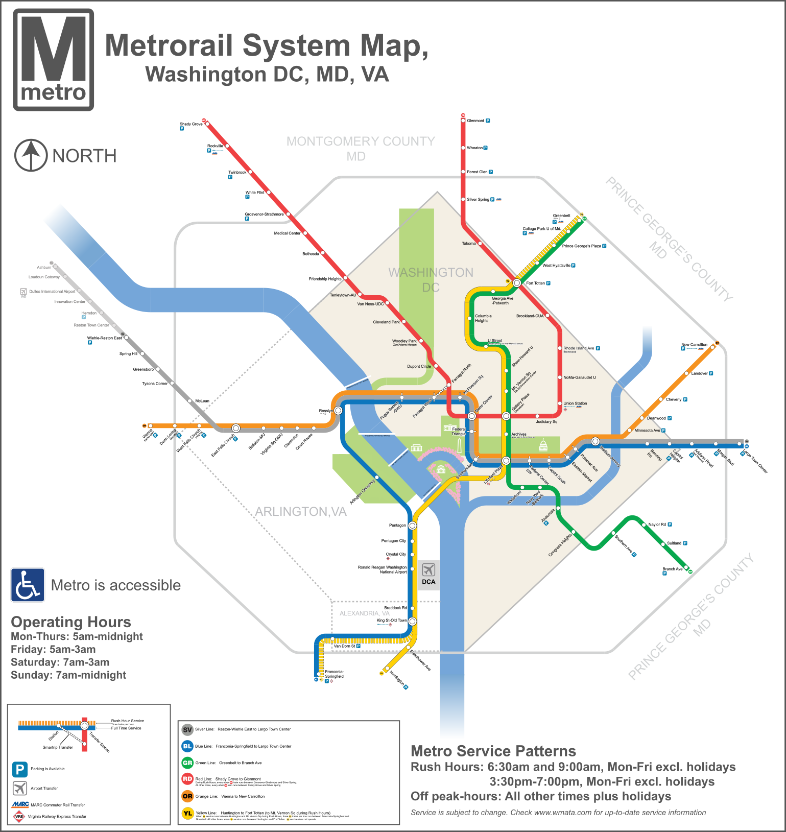
English: A redesigned map of the Washington Metro. Created using Adobe Illustrator. This map shows the Rush Plus service details and is designed to be more geographically matched than the current metro map. Two files from Commons were used in the creation of the Map. They are File:WMATA Metro Logo.svg, and File: Amtrak logo.svg |
| Date | |
| Source | Own work |
| Author | VeggieGarden |
This vector image was created with Adobe Illustrator by v.

Licensing
I, the copyright holder of this work, hereby publish it under the following license:
| This file is made available under the Creative Commons CC0 1.0 Universal Public Domain Dedication. | |
| The person who associated a work with this deed has dedicated the work to the public domain by waiving all of their rights to the work worldwide under copyright law, including all related and neighboring rights, to the extent allowed by law. You can copy, modify, distribute and perform the work, even for commercial purposes, all without asking permission.
|
File history
Click on a date/time to view the file as it appeared at that time.
| Date/Time | Thumbnail | Dimensions | User | Comment | |
|---|---|---|---|---|---|
| current | 17:31, 3 December 2015 | | 1,539 × 1,629 (4.48 MB) | Pi.1415926535 | Reduce height |
| 17:27, 3 December 2015 |  | 1,539 × 1,779 (4.47 MB) | Pi.1415926535 | Fixed misaligned background | |
| 22:11, 2 December 2015 |  | 1,539 × 1,779 (4.47 MB) | Pi.1415926535 | Update station names | |
| 21:24, 2 December 2015 |  | 1,539 × 1,779 (4.48 MB) | Pi.1415926535 | Increase width for better visibility (no other changes) | |
| 09:23, 19 August 2014 |  | 512 × 592 (4.09 MB) | Rcsprinter123 | Cemetery, Mongomery | |
| 02:06, 18 October 2013 |  | 512 × 592 (3.98 MB) | VeggieGarden | Added parking at Wiehle-Reston East Station, fixed "accessible" spelling error | |
| 23:56, 16 October 2013 |  | 512 × 592 (3.86 MB) | VeggieGarden | Fixed More Errors, made the map more readable | |
| 23:56, 16 October 2013 |  | 512 × 592 (3.86 MB) | VeggieGarden | Fixed More Errors, made the map more readable | |
| 23:43, 16 October 2013 |  | 512 × 592 (586 KB) | VeggieGarden | Fixed errors | |
| 23:35, 16 October 2013 |  | 512 × 592 (284 KB) | VeggieGarden | Brand New design, more accurate, addition of Silver Line Phase 1. The map is also easier to understand. |
File usage
The following 2 pages use this file:
Global file usage
The following other wikis use this file:
- Usage on pt.wikipedia.org
- Usage on zh.wikipedia.org