
European route E40
This article needs additional citations for verification. (June 2009) |
 | ||||
|---|---|---|---|---|
 | ||||
 E40 interchange near Bruges, Belgium | ||||
| Route information | ||||
| Length | 8,641 km (5,369 mi) | |||
| Major junctions | ||||
| West end | ||||
| ||||
| East end | Ridder, Kazakhstan | |||
| Location | ||||
| Countries | France, Belgium, Germany, Poland, Ukraine, Russia, Kazakhstan, Uzbekistan, Turkmenistan, Kyrgyzstan | |||
| Highway system | ||||
| ||||
European route E40 (E40) is a European route connecting Calais in France with Ridder in Kazakhstan near the border with Russia and China. 8,641 kilometres (5,369 miles) long, is the longest route in the International E-road network. A different route, connecting Calais and Ridder, is about 2,000 kilometres (1,200 miles) shorter, mostly using the E30 via Berlin, Moscow, and Omsk. The E40 differs from that route in order to provide additional direct east–west access to Uzbekistan, Turkmenistan, and Kyrgyzstan, with a combined population base approaching 50 million people as of 2021.
Since 2014, parts of the road in eastern Ukraine have been under the control of the separatist Donetsk People's Republic and Luhansk People's Republic. During the Russian invasion of Ukraine, Russia took direct control of the areas in Donbas.
Route
[edit]France
[edit]Belgium
[edit] A18: Adinkerke - Veurne - Jabbeke (E404)
 A10: Jabbeke (E404) - Bruges (E403) - Gent (E17) - Brussels (E19)
 R0 (Brussels Ring): Brussels (E19 Towards E411)
 A3: Brussels - Leuven (E314) - Liège (E25 / E42 / E313, Towards E46) - Verviers (E42) - Lichtenbusch (E421)
Germany
[edit] A 44: Aachen (E 314)
 A 4: Aachen (E 314) - Cologne (E 31 / E 35, Towards E 29 / E 37) - Olpe (E 41)
 A 45: Olpe (start of concurrency with E 41) - Siegen - Gießen (E 44, end of concurrency with E 41)
 B 49: Gießen (E 41 / E 44)
 B 429: Gießen
 A 480: Gießen (E 451)
 A 5: Gießen (E 451) - Bad Hersfeld (E 45)
 A 7: Bad Hersfeld (E 45)
- A 4: Bad Hersfeld (E 45) - Eisenach - Erfurt - Zwickau (E 49 / E 51 / E 40) - Chemnitz (E 441) - Dresden (E 55) - Görlitz
Poland
[edit] A 4: Zgorzelec - Bolesławiec (E36) - Legnica (E65) - Wrocław (E67) - Opole - Gliwice - Katowice - Mysłowice (E75, start of concurrency with E462) - Kraków (E77, end of concurrency with E462) - Rzeszów (E371) - Korczowa
Ukraine
[edit] M 10: Krakovets - Lviv (
 E372
E372 E471)
E471) M 06: Lviv - Dubno (E85) - Rivne - Zhytomyr (E583) - Kyiv (E95 / E101)
 M 03: Kyiv (E95 / E101) - Lubny - Poltava (E584) - Kharkiv (E105) - Sloviansk - Debaltseve (E50)
 M 30: Debaltseve (E50) - Luhansk - Izvaryne
Russia
[edit]- R260: Kamensk-Shakhtinsky (E40) - Volgograd (E119)
 R 22: Volgograd (start of concurrency with E119) - Astrakhan (end of concurrency E119)
- 12A-235: Astrakhan - Krasny Yar
Kazakhstan (west)
[edit] A 27: Kotyaevka - Atyrau (start of concurrency with E121) - Dossor
 A 33: Dossor - Beyneu (end of concurrency with E121)
 P 1: Beyneu (E121) - Akjigit - Border with Uzbekistan
Uzbekistan (west)
[edit]- A380 A380 Road: Border with Kazakhstan - Karakalpakstan - Qo'ng'irot - Xojeli - Nukus
- A381 A381 Road: Xojeli - Border with Turkmenistan
Turkmenistan
[edit]- Border with Uzbekistan - Konye-Urgench - Daşoguz (
 E003)
E003)
Uzbekistan (east)
[edit]- 4P159 4P159 Road: Border with Turkmenistan - Shovot - Urgench
- 4P156 4P156 Road: Urgench - Hazorasp - A380
- A380 A380 Road: 4P156 - Bukhara (
 E60
E60 E004)
E004) - M37 M37 Road: Bukhara ( E60 E004) - Navoiy - Samarqand (
 E005)
E005) - M39 M39 Road: Samarkand - Jizzax - Sardoba
- A373 A373 Road: Sardoba - Oqoltin
- M34 M34 Road: Oqoltin - Sirdaryo
- M39 M39 Road: Sirdaryo (start of concurrency with E123) - Chinoz - Tashkent (
 E007) -G‘ishtko‘prik - Border of Kazakhstan
Kazakhstan (middle)
[edit] A 2: Zhibek Zholy - Shymkent (end of concurrency with E123) - Taraz - Merki[a]
 M 39: Merki - Chaldovar
Kyrgyzstan
[edit]- ЭМ-03 ЭМ-03 Road: Border of Kazakhstan - Chaldovar - Kara-Balta (
 E010)
E010) - ЭМ-04 ЭМ-04 Road: Kara-Balta ( E010) - Bishkek (Start of Concurrency with
 E125)
E125) - ЭМ-02 ЭМ-02 Road: Bishkek Bypass
- ЭМ-01 ЭМ-01 Road: Bishkek - Border of Kazakhstan
Kazakhstan (east)
[edit]- A 2: Korday - Almaty (E012, end of concurrency with E125)
 A 3: Almaty (E125 / E012) - Sary-Ozek (E013) - Taldykorgan - Usharal (E014) - Ayagoz - Qalbatau (E127) - Öskemen
 A 10: Öskemen - Sekisovka
 A 9: Sekisovka - Ridder
Gallery
[edit]-

-
 Crossing a railway at Chemnitz in eastern Germany
 -
 at Zabrze in Upper Silesian Industrial Region in Poland
 -
 E40 road on Ukrainian highway Kyiv-Zhytomyr
 -
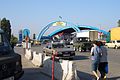 On Kazakh-Kyrgyz border at Korday
 -

-

-
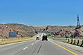 Between Almaty and Taldyqorghan near city Konaev (Kazakhstan)


.jpg)


Notes
[edit]References
[edit]External links
[edit]- UN Economic Commission for Europe: Overall Map of E-road Network (2007)
- The E40 as a Path of Remembrance in Europe
