Capital Region (Iceland)
Capital Region
Höfuðborgarsvæðið (Icelandic) | |
|---|---|
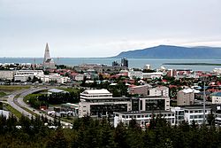
Reykjavík from Perlan Rooftops from Hallgrímskirkja Reykjavík from Hallgrímskirkja Panorama from Perlan | |
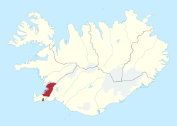
 Map of Iceland with the Capital Region highlighted | |
| Coordinates: 64°08′N 21°56′W / 64.133°N 21.933°W | |
| Country | Iceland |
| Largest town | Reykjavík |
| Area | |
• Total | 1,046 km2 (404 sq mi) |
| Population (2025)[2] | |
• Total | 249,054 |
| • Density | 238.10/km2 (616.7/sq mi) |
| Time zone | UTC+00:00 (WET) |
| ISO 3166 code | IS-1 |
The Capital Region (Icelandic: Höfuðborgarsvæðið [a]) is a region in southwestern Iceland. It is one of the two classified Nomenclature of Territorial Units for Statistics (NUTS-2) statistical regions of Iceland. The region encompasses an area of 1,046 km2 (404 sq mi), and consists of the national capital Reykjavík and six municipalities around it. Though it is much smaller than the other regions of Iceland, the region hosts about two-thirds of the population of the country.
Classification
[edit]The country of Iceland is organized into eight regions for statistical and administrative purposes.[3] The Nomenclature of Territorial Units for Statistics (NUTS) organizes the country into two broader level sub-divisions.[4][5] These are classified as a NUTS-2 statistical regions of Iceland, and incorporate one or more regions within it.[6][7] The regions form the NUTS-3 territorial units under them.[3]
Geography
[edit]The Capital Region of Iceland incorporates the regions around the nation's capital Reykjavik, encompassing an area of 1,046 km2 (404 sq mi).[1] The region is located in the south-western corner of the island, which is situated at the confluence of the North Atlantic and Arctic oceans.[8] Apart from its western coast, the region is bordered by Southern Peninsula to the south, Western Region to the north, and Southern Region to the east.[3]
Sub-divisions
[edit]Seven municipalities make up the Capital Region with Reykjavík being the most populated by far with 138,772 inhabitants.[2][9] While Kjósarhreppur is the largest municipality by area, spread around 284 km2 (110 sq mi), it is entirely rural and has the least population. Seltjarnarnes is the smallest municipality by land area.[1] Each municipality has its own elected council, and take care of utilities like waste policy, public transport and fire fighting.[10]

| Municipality | Population (2025)[11] | Area (km2)[1] | Density (Pop/km2) |
|---|---|---|---|
| Reykjavík | 138,772 | 244 | 568.74 |
| Kópavogur | 40,040 | 110 | 364 |
| Hafnarfjörður | 31,525 | 174 | 181.18 |
| Garðabær | 20,116 | 46 | 437.30 |
| Mosfellsbær | 13,715 | 186 | 73.74 |
| Seltjarnarnes | 4,585 | 2 | 2,292.50 |
| Kjósarhreppur | 301 | 284 | 1.06 |
| Total | 249,054 | 1,046 | 238.10 |
Demographics
[edit]
|
| ||||||||||||||||||||||||||||||||||||||||||
| Source: Statistics Iceland | |||||||||||||||||||||||||||||||||||||||||||
The region hosts about two-thirds of the population of the country.[2] As of 2025, there are 249,054 people residing the region, of whom 126,527 are male, 122,378 are female, and 149 are non-binary/other. The population density is of 238.10 inhabitants per square kilometre.[2] The region has a very high Human Development Index, and is one of the most developed regions in Europe.[12] Of the labor force, nearly 25% are involved in professional and administrative work including government offices.[13]
For statistic purposes, Statistics Iceland has defined contiguous urban areas which are different from municipal boundaries. An urban area might straddle multiple municipalities and a single municipality may contain more than one urban area.[14] The Greater Reykjavik area houses more than 98% of the population of the region, incorporating three of the six municipalities completely, and most parts of Reykjavik and two other municipalities except Kjósarhreppur. The remaining population is spread across the minor urban areas of Álftanes, Grundarhverfi, and Mosfellsdalur. There is a small percent of population that is classified as rural.[14]
| Urban area | Population (2024) | Municipalities |
|---|---|---|
| Greater Reykjavík | 239,733 | Reykjavík, Kópavogur, Hafnarfjörður, Garðabær, Mosfellsbær, Seltjarnarnes |
| Álftanes | 2,487 | Garðabær |
| Grundarhverfi | 530 | Reykjavík |
| Mosfellsdalur | 267 | Mosfellsbær |
| Rural | 1,160 | Kjósarhreppur |
| Total | 244,177 |
See also
[edit]Notes
[edit]- ^ lit. 'capital area'; pronounced [ˈhœːvʏðˌpɔrkarˌsvaiːðɪθ] ⓘ
References
[edit]- ^ a b c d "Náttúrufræðistofnun - Sveitarfélagasjá" [National Land Survey of Iceland]. Government of Iceland. Retrieved 19 December 2024.
- ^ a b c d e "Population by regions, sex and age 1 January 1998-2025". Statistics Iceland. 1 January 2025. Retrieved 20 March 2025.
- ^ a b c "Iceland in figures, 2018". Statistics Iceland. p. 3. Retrieved 23 November 2016.
- ^ "NUTS classification". Eurostat. Retrieved 1 June 2024.
- ^ "Regions in the European Union: Nomenclature of territorial units for statistics" (PDF). European Commission. Archived from the original (PDF) on 21 February 2011. Retrieved 25 November 2012.
- ^ "NUTS regions". Eurostat. Retrieved 1 June 2024.
- ^ "Commission Regulation (EU) 2016/2066 of 21 November 2016 amending the annexes to Regulation (EC) No 1059/2003 of the European Parliament and of the Council on the establishment of a common classification of territorial units for statistics (NUTS)". EUR-Lex. Retrieved 3 February 2019.
- ^ "Iceland". CIA World fact book. Retrieved 1 June 2024.
- ^ "Association of municipalities in the Capital area". Archived from the original on 7 October 2021. Retrieved 5 June 2010.
- ^ Sigurður Guðmundsson (18 August 2000). "Hvernig eru hugtökin dreifbýli og landsbyggð skilgreind hér á landi?". The Icelandic Web of Science. Retrieved 6 June 2010.
- ^ "Population by municipalities, sex and age 1 January 1998-2025". Statistics Iceland. 1 January 2025. Retrieved 20 March 2025.
- ^ "Sub-national HDI - Area Database - Global Data Lab". Global datalab. Retrieved 1 June 2018.
- ^ "Economic composition". Harvard University. Retrieved 1 June 2024.
- ^ a b "Population by localities, sex and age 1 January 2001-2024". Statistics Iceland. 1 January 2024. Retrieved 9 December 2024.
External links
[edit] Geographic data related to Capital Region (Iceland) at OpenStreetMap


