
A58 road
 | ||||
|---|---|---|---|---|
 | ||||
 | ||||
| Route information | ||||
| Length | 81.8 mi[1][2] (131.6 km) | |||
| Major junctions | ||||
| West end | ||||
| ||||
| East end | ||||
| Location | ||||
| Country | United Kingdom | |||
| Counties | Merseyside Greater Manchester West Yorkshire | |||
| Primary destinations | St Helens Bolton Bury Rochdale Halifax Leeds | |||
| Road network | ||||
| ||||
The A58 is a major road in Northern England running between Prescot, Merseyside and Wetherby, West Yorkshire.
Route from West to East
[edit]Its westbound start is at Prescot on the outskirts of Liverpool via Greater Manchester and West Yorkshire to the eastern terminus at Wetherby. The road goes through the following locations:
- St Helens
- Ashton-in-Makerfield
- Hindley
- Westhoughton
- Bolton
- Bury
- Heywood
- Rochdale
- Littleborough
- The Pennines
- Ripponden
- Sowerby Bridge
- Halifax
- Hipperholme
- Birkenshaw
- Drighlington
- New Farnley
- Leeds City Centre as the A58(M) motorway (part of the Leeds Inner Ring Road),
- Scarcroft
- Bardsey
- Collingham
- to its terminus at Wetherby
History
[edit]Leeds to Wetherby
[edit]The original route between Leeds and Wetherby has a dual carriageway diverting from Roundhay Road/Wetherby Road, at the old Fforde Grene junction in Harehills. It runs along the Easterly Road dual carriageway passing Oakwood and Gipton. The re-routed A58 meets its original route at Boggart Hill in Seacroft. The re-routed section was constructed in the 1930s and had a branch of the Leeds Tramway running along the central reservation until the 1950s.[3] The proposed Leeds Supertram was also to run this route.[4]
Junction list
[edit]| County | Location | mi[1][2] | km | Destinations | Notes |
|---|---|---|---|---|---|
| Merseyside | Prescot | 0.0 | 0.0 | Western terminus; M57 junction 2 | |
| Knowsley– Prescot boundary | 1.1 | 1.8 | Prescot | ||
| St Helens | 3.9 | 6.3 | To A580 signed westbound only; western terminus of A570 concurrency; southern terminus of A571 | ||
| 4.5 | 7.2 | A570 signed eastbound only; eastern terminus of A570 concurrency | |||
| 5.2 | 8.4 | Western terminus of A572 | |||
| 6.9 | 11.1 | Western terminus of A599 | |||
| 7.2 | 11.6 | ||||
| Greater Manchester | Ashton-in-Makerfield | 8.9– 9.0 | 14.3– 14.5 | M6 junction 24 | |
| 9.6 | 15.4 | Brief concurrency; Liverpool signed eastbound only | |||
| 9.8 | 15.8 | Southeastern terminus of A5062 | |||
| Platt Bridge | 12.4 | 20.0 | Abram signed eastbound only; western terminus of A573 concurrency | ||
| 12.6 | 20.3 | Information signed westbound only; eastern terminus of A573 concurrency | |||
| Hindley | 14.0 | 22.5 | |||
| Westhoughton | 18.0 | 29.0 | |||
| Westhoughton– Bolton boundary | 18.5 | 29.8 | M61 junction 5 | ||
| Bolton | 19.3 | 31.1 | Southern terminus of A676 | ||
| 20.7 | 33.3 | Information signed eastbound only | |||
| 23.0 | 37.0 | Northwestern terminus of A6099 | |||
| 23.9 | 38.5 | ||||
| 24.8 | 39.9 | ||||
| 26.1 | 42.0 | Leigh and Manchester signed westbound only; northern terminus of A579 | |||
| Bury | 27.4 | 44.1 | Northern terminus of A665 | ||
| 30.4 | 48.9 | Western terminus of A56 concurrency | |||
| 30.7 | 49.4 | Eastern terminus of A56 concurrency | |||
| 31.3 | 50.4 | ||||
| 32.0 | 51.5 | Liverpool signed westbound only; M66 junction 2 | |||
| Heywood | 34.3 | 55.2 | Information signed eastbound only; northern terminus of A6046 | ||
| 34.6 | 55.7 | Information signed westbound only; eastern terminus of A6047 | |||
| Rochdale | 36.3 | 58.4 | Information signed westbound only | ||
| 36.5 | 58.7 | ||||
| 37.2 | 59.9 | Western terminus of A640 | |||
| 37.4 | 60.2 | Southern terminus of A6060 | |||
| 37.7 | 60.7 | Southern terminus of A680 | |||
| 38.0 | 61.2 | ||||
| 38.9 | 62.6 | To A640 and Huddersfield signed eastbound only, To A671, A6193, Manchester and Oldham westbound only; northern terminus of A664 | |||
| Littleborough | 41.1 | 66.1 | Southern terminus of A6033 | ||
| West Yorkshire | Ripponden | 48.5 | 78.1 | Information signed westbound only; northeastern terminus of A672 | |
| Sowerby Bridge | 51.6 | 83.0 | Southern terminus of A6139 | ||
| 51.9 | 83.5 | Information signed eastbound only; western terminus of A6026 | |||
| 52.0 | 83.7 | Pye Nest Road (A6142 east) | Western terminus of A6142 | ||
| Halifax | 52.6 | 84.7 | Information signed westbound only; eastern terminus of A6142 | ||
| 53.0 | 85.3 | ||||
| 54.2 | 87.2 | Ovenden signed eastbound only, Town centre, Manchester, Elland and Delholme westbound only | |||
| 54.4– 54.6 | 87.5– 87.9 | Western terminus of A647 | |||
| 55.5 | 89.3 | Western terminus of A6036 | |||
| Hipperholme | 56.7 | 91.2 | To A629 signed westbound only | ||
| Lightcliffe and Bailiff Bridge signed eastbound only; western terminus of A649 | |||||
| Wyke | 58.4 | 94.0 | |||
| Cleckheaton | 60.4– 60.7 | 97.2– 97.7 | Southern terminus of M606; northern terminus of A638; M62 junction 26 | ||
| Birkenshaw | 62.3 | 100.3 | |||
| Drighlington | 63.1 | 101.5 | |||
| Leeds | 67.0 | 107.8 | To A647, Bradford and Pudsey signed eastbound only | ||
| 68.2– 68.7 | 109.8– 110.6 | To A6110 signed eastbound only, The West and Halifax westbound only; eastern terminus of A643 / A62 | |||
| 68.5– 68.8 | 110.2– 110.7 | ||||
| 68.8– 70.2 | 110.7– 113.0 | see | |||
| 70.2 | 113.0 | Southeastern terminus of A660 | |||
| 70.7 | 113.8 | No access from A58 east to A61 south or from A58 west to A61 north | |||
| 74.2 | 119.4 | Ring Road (B6902) – Shadwell, Seacroft, Moortown, Cross Gates | |||
| 74.7 | 120.2 | To A61, A660, Harrogate and Skipton signed eastbound only | |||
| Collingham | 80.1 | 128.9 | Western terminus of A659 concurrency | ||
| 80.6 | 129.7 | Eastern terminus of A659 concurrency | |||
| Wetherby | 81.8 | 131.6 | Eastern terminus; southeastern terminus of A661 | ||
1.000 mi = 1.609 km; 1.000 km = 0.621 mi
| |||||
Gallery
[edit]-

-
-
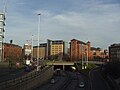
 A58(M), Leeds Inner Ring Road by the Leeds International Pool
 -
 A58(M), Leeds Inner Ring Road passing underneath the Nuffield Hospital


References
[edit]- ^ a b "A58, Prescot, UK to Parr St, Saint Helens WA9 1JY, UK to Spinners Arms, 165 Castle Hill Rd, Hindley, Wigan WN2 4BW, UK to Crompton Way, Bolton BL1 8UA, UK to 18 Haymarket St, Bury BL9 0AQ, UK to Rochdale, UK to A58, Halifax, UK to Holbeck, Leeds LS12 4TJ, UK to 53.7980362, -1.5592893 to Leeds LS2 3AX, UK". Google Maps. Retrieved 1 July 2025.
- ^ a b "Leeds LS2 3AX, UK to Wetherby LS22 5HD, UK". Google Maps. Retrieved 1 July 2025.
- ^ Buckley, Richard (2011). Leeds Trams 1871–1959. Catrine: Stenlake. p. 54. ISBN 9781840335309.
- ^ "Leeds Supertram Route Map". Railway Technology. Retrieved 20 March 2016.
External links
[edit]![]() Media related to A58 road (England) at Wikimedia Commons
Media related to A58 road (England) at Wikimedia Commons
Roads in Zone 5 of the Great Britain road numbering scheme | ||
|---|---|---|
53°54′18″N 2°09′01″W / 53.90499°N 2.15023°W
This England road or road transport-related article is a stub. You can help Wikipedia by expanding it. |